Blithfield
| Blithfield | |
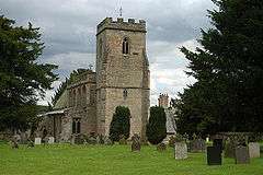 St Leonard's Church, Blithfield |
|
 Blithfield |
|
| Population | 230 (2011)[1] |
|---|---|
| OS grid reference | SK044239 |
| Civil parish | Blithfield |
| District | East Staffordshire |
| Shire county | Staffordshire |
| Region | West Midlands |
| Country | England |
| Sovereign state | United Kingdom |
| Postcode district | ST16-ST21 |
| Dialling code | 01283 |
| Police | Staffordshire |
| Fire | Staffordshire |
| Ambulance | West Midlands |
| EU Parliament | West Midlands |
| UK Parliament | East Staffordshire |
|
|
Coordinates: 52°48′46″N 1°56′05″W / 52.8129°N 1.9347°W
Blithfield is a civil parish in the East Staffordshire district of Staffordshire, England. It includes the settlements of Admaston (a small hamlet in Staffordshire), Newton (Which forms part of the A34, linking between Walsall and Cannock) along with Blithfield Hall, home of the Bagot family since 1360.[2] It is situated 7.5 miles (12.1 km) southwest of Uttoxeter and 4.5 miles (7.2 km) north of Rugeley. Blithfield and Admaston comprise 1,414 acres (572 ha) of land, with Newtown occupying 1,744 acres (706 ha).[3] The nearest railway stations are Rugeley Trent valley (3miles away) and Rugeley town (3 miles away).
History
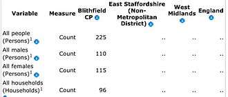
A parish like Blithfield is normally formed around a small settlement. Blithfield used to be centered around the Parish Church. At the end of the 1800s Church and State divided and this area is now represented as "a local authority by the Blithfield Parish Council and the Church of England by the Parochial Church Council".[4] The population in Blithfield decreased from 439 people in 1801 to 262 people in 1961.[5] According to the 2001 census it has a population of 225, situated within 96 households. The number of houses has stayed relatively stable since 1830, fluctuating from 81 houses in 1830, dropping to 65 in 1920 and then steadily increasing until 2001.[6] 173 of the 225 people in 2001 were between the ages of 16 and 74.[7] Blithfield Reservoir takes up much of the parish and the area is home to the Bagot goat.
Etymology
The first part of the name "Blithfield" is simply an alternative spelling of the word "Blythe", which originates from Old English word "blitha" meaning 'gentle'. The second part stems from the Old English "feld", which meant 'open or accessible land'. However, by the time Blithfield became its name, it might "just as well be interpreted in the modern sense of 'field'".[8]
Domesday book
The Domesday Book, commissioned by William the Conqueror, is a land survey, which was completed in 1086. Its purpose was to assess the extent of the land and of resources owned in England, and the amount of the taxes that could be raised at the time.[9]
Blithfield (1086) in the Domesday book:
| County | Staffordshire |
| Total population | 13 households |
| Total tax assessed | 1 Geld units (Very small) |
| Taxable units | Taxable value- 1 Geld units |
| Value | Value to Lord in 1086- £1 |
| Households | 7 villagers, 1 smallholder, 4 slaves, 1 priest. |
| Lord in 1066 | Edmund |
| Lord in 1086 | Roger of Lacy |
Church
St Leonard's Church dates from the 13th century, it is set away from the modern village of Admaston, and lies just west of the modern Blithfield Hall. The church was built between the 13th and 19th centuries. In the late 13th and early 14th centuries, four "bay arcades" were built. The base of the western tower and the windows were constructed in the 14th century, and the "clerestory above the nave" was added in the 15th century. The upper part of the tower, with stained glass in the west window is thought to date back to 1525. The rest of the church dates to the 19th century. The remains of a 13th- or 14th-century cross can still be seen in the churchyard.[11] The church contains tombs of the Bagot family as well as an original helmet, ancient stained glass windows and a floor paved in Minton tiles.[12] Parish registers of the church begin in 1538. The churchyard contains a war grave of a Royal Flying Corps officer of World War I.[13]
Medieval Blithfield

The "late-Saxon" settlement of Blithfield, which appears in the "Doomsday" did not last, and the last documented evidence of the village was in 1334. This site of the original village is now defined as a "Deserted Medieval Village (DMV)" with hardly any visible remnants. However, the site is strongly thought to have been located within the grounds of Blithfield Hall. The original mansion of Blithfield Hall, was built with a moat in the 1390s by Sir John Bagot. It is thought, however, that the Lord of Blithfield was unhappy with some of the work done on the hall, so in 1398 the carpenter, Robert Stanlowe, was sued. Although nothing of this period remains, a small area of the "west range", of Blithfield hall, that is still standing can be dated back to around the 16th century, the current hall dates back to building periods between 1740 and 1822.[14] The present hall, situated nine miles east of Stafford, is mainly from the Elizabethan period and is a grade one listed building: Blithfield Hall.
Modern Blithfield
Blithfield reservoir

Blithfield Reservoir is the most apparent modern construction. It was opened by Queen Elizabeth The Queen Mother in October 1953 after six years of building. The project was proposed by the "South Staffordshire Water PLC"[15] who, during the 1930s and 1940s purchased 2,350 acres (952 ha) of land in the Blythe Valley, to put into action their plan, much of this land (1,585 acres/642 ha) was bought from Lord Bagot, the owner of Blithfield Hall. The reservoir itself covers a smaller area of land, approximately 790 acres (320ha). Ownership of the farmland bordering the reservoir allowed control over farming methods and thus minimised any risk of water pollution.[16] It was originally planned to start building the reservoir in 1939, but this was postponed until 1947, due to the onset of World War II. A bridge, now carrying the B5013 road, separates the water of the reservoir into two unequal parts, the shallower section is used mainly for fishing and the deeper section, close to the dam, is for the sailing boats.[17] Before the Blithfield Reservoir was built, the land consisted mostly of fields with small areas of woodland. The land was predominantly used by farmers for rearing animals and growing crops.[18]
South Staffordshire Water PLC
The South Staffordshire Water plc, have granted a lease to the West Midland Bird Club for the purpose of observing and recording birds. It is one of the most important sites for wetland birds in the Midlands. The site was first opened in the 1970s and this continues, ensuring that the changes in the birdlife of the site are able to be observed and recorded[19]
References
- ↑ "Civil Parish population 2011". Retrieved 5 December 2015.
- ↑ Blithfield Hall Archived 22 March 2009 at the Wayback Machine.
- ↑ Genuki- Uk & Ireland Genealogy- Retrieved 27.03.2012
- ↑ British Towns and Villages Network- Retrieved 14.03.2012
- ↑ Vision of Britain through time- Historical statistics- Population- Retrieved 24.03.2012
- ↑ Vision of Britain through time- Historical statistics- Housing-Retrieved 24.03.2012
- ↑ neighbourhood statistics- Parish profile- Households- Retrieved 12.03.2012
- ↑ Blithfield history- Etymology- (Gelling & Cole, p.275; Poulton-Smith, p.19)- Retrieved 10.04.2012
- ↑ The Domesday book- Background
- ↑ Domesday Book,(Powell-Smith,A)
- ↑ Blithfield history- Saint Leonard's Church- Retrieved 15.02.2012
- ↑ Minton Tiles in the Churches of Staffordshire, A Report by Lynn Pearson for the Tiles and Architectural Ceramics Society
- ↑ CWGC Casualty Record.
- ↑ Blithfield history-Medieval Blithfield (A.D.1066 - 1540)(Blithfield hall) Retrieved 15.02.2012
- ↑ Blithfield History- Modern Blithfield- Reservoir -Retrieved 16.02.2012
- ↑ Blithfield reservoir-Retrieved 19.02.2012
- ↑ Blithfield History- Modern Blithfield -Retrieved 16.02.2012
- ↑ Blithfield Reservoir-Retrieved 19.02.2012
- ↑ "Blithfield Reservoir". West Midland Bird Club. Archived from the original on 16 March 2012. Retrieved 24 February 2012.
External links
| Wikimedia Commons has media related to Blithfield. |