Blatobulgium

A map of Roman sites in northern Britain c. 84, including Blatobulgium (marked as 'Birrens').
Blatobulgium was a Roman fort, located at the modern-day Birrens, Dumfriesshire, in Scotland.
Name
Blatobulgium is recorded in the Antonine Itinerary. The name derives from the Brittonic roots *blāto- 'bloom, blossom' or *blāto- (from earlier *mlāto-), 'flour' and *bolgo-, 'bag, bulge'. The name may mean 'flowery hillock' or 'flowery hollow'. However, as there are granaries at the fort, Blatobulgium may be a nickname meaning 'flour-sack'.[1]
_Roman_Fort_-_geograph.org.uk_-_2177289.jpg)
Western edge of the fort
History
The fortress formed the northern terminus of the Roman-era Watling Street, Route 2 of the Antonine Itinerary. It was located in the territory of the Selgovae.
References
- ↑ Rivet, A. F. L.; Smith, Colin (1981) [1979]. The Place-Names of Roman Britain. London: Book Club Associates. pp. 268–269.
- See also Rivet, A. L. F.; Jackson, Kenneth (1970). "The British Section of the Antonine Itinerary". Britannia. 1: 69. JSTOR 525833.
- The interpretations of the name are summarised by James, Alan G. (2014). The Brittonic Language in the Old North: A Guide to the Place-Name Evidence (PDF). Volume 2: Guide to the Elements. pp. 39, 42. Archived from the original (PDF) on 2014-09-11.
Coordinates: 55°03′54″N 3°13′28″W / 55.0651°N 3.2244°W
| Wall Forts (East to West) | 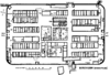 | |
|---|---|---|
| Outpost Forts | ||
| Stanegate Forts |
| |
| Supply Forts | ||
| Cumbrian Coast Forts (North to South) |
| |
This article is issued from Wikipedia - version of the 9/21/2016. The text is available under the Creative Commons Attribution/Share Alike but additional terms may apply for the media files.