Blagovica
| Blagovica Glogowitz | |
|---|---|
| Village | |
|
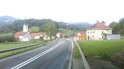
Postcard of Blagovica | |
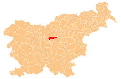
 Blagovica Location in Slovenia | |
| Coordinates: 46°10′32.97″N 14°48′14.08″E / 46.1758250°N 14.8039111°ECoordinates: 46°10′32.97″N 14°48′14.08″E / 46.1758250°N 14.8039111°E | |
| Country |
|
| Traditional region | Upper Carniola |
| Statistical region | Central Slovenia |
| Municipality | Lukovica |
| Area | |
| • Total | 0.92 km2 (0.36 sq mi) |
| Elevation | 410.2 m (1,345.8 ft) |
| Population (2002) | |
| • Total | 101 |
| Post code | 1223 |
| Area code(s) | 01 |
| [1] | |
Blagovica (pronounced [blaˈɡoːʋitsa]; German: Glogowitz[2]) is a village in the Municipality of Lukovica in the eastern part of the Upper Carniola region of Slovenia.[3]
Blagovica lies between the Radomlja River and Zlatenščica Creek and is the local center of the east-central part of the Radomlja Valley (also known as the Black Valley, Slovene: Črni graben) with a primary school, a post office, a bar, a gas station and a parish church. The village also has several organizations, including the Blagovica Volunteer Fire Department, the Blagovica Hiking Club, the Blagovica Cultural Society, the Blagovica Rural Youth Organisation, and the Trojane–Blagovica Rural Women's Society.
Blagovica is also the seat of the Parish of Blagovica and Blagovica Local Community, which was an independent municipality until 1959 but then became a part of the Municipality of Domžale. Since 1995 the community has been part of the Municipality of Lukovica.
The parish church in the settlement is dedicated to Saint Peter.[4]
References
- ↑ Statistical Office of the Republic of Slovenia
- ↑ Leksikon občin kraljestev in dežel zastopanih v državnem zboru, vol. 6: Kranjsko. 1906. Vienna: C. Kr. Dvorna in Državna Tiskarna, p. 16.
- ↑ Lukovica municipal site
- ↑ Družina RC Church in Slovenia journal site
External links
-
 Media related to Blagovica at Wikimedia Commons
 - Blagovica on Geopedia