Blackfriars Road
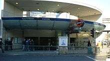
Southwark tube station on the corner of Blackfriars Road and The Cut.
Blackfriars Road is a road in Southwark, SE1. It runs between St George's Circus at the southern end and Blackfriars Bridge over the River Thames at the northern end, leading to the City of London. Halfway up on the west side is Southwark tube station, on the corner with The Cut. Opposite is Palestra, a large new office building which houses the Surface transport division of TfL.
The road forms part of the A201. The road adjoins Stamford Street and Southwark Street at the northern end. Originally known as Surrey Street, the road was built in the 1760s as the south approach to Blackfriars Bridge, and was laid out by the bridge surveyor, Robert Mylne.[1]
See also
References
- ↑ Ward, Robert (2007) The Man Who Buried Nelson: The Surprising Life of Robert Mylne. London: Tempus Publishing. ISBN 978-0-7524-3922-8. p.76
External links
Coordinates: 51°30′20″N 0°06′16″W / 51.50556°N 0.10444°W
This article is issued from Wikipedia - version of the 2/4/2016. The text is available under the Creative Commons Attribution/Share Alike but additional terms may apply for the media files.