Bischofsheim an der Rhön
| Bischofsheim a.d.Rhön | ||
|---|---|---|
| ||
 Bischofsheim a.d.Rhön | ||
Location of Bischofsheim a.d.Rhön within Rhön-Grabfeld district 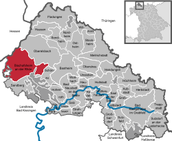 | ||
| Coordinates: 50°24′N 10°01′E / 50.400°N 10.017°ECoordinates: 50°24′N 10°01′E / 50.400°N 10.017°E | ||
| Country | Germany | |
| State | Bavaria | |
| Admin. region | Unterfranken | |
| District | Rhön-Grabfeld | |
| Government | ||
| • Mayor | Udo Baumann (CSU) | |
| Area | ||
| • Total | 67.72 km2 (26.15 sq mi) | |
| Population (2015-12-31)[1] | ||
| • Total | 4,698 | |
| • Density | 69/km2 (180/sq mi) | |
| Time zone | CET/CEST (UTC+1/+2) | |
| Postal codes | 97653 | |
| Dialling codes | 09772 | |
| Vehicle registration | NES | |
| Website | www.bischofsheim-rhoen.de | |

Bischofsheim an der Rhön is a town in the district Rhön-Grabfeld, in Bavaria, Germany. It is situated in the Rhön Mountains, 29 km southeast of Fulda.
Town Structure
Several originally separate villages became part of the town Bischofsheim. These are Frankenheim, Haselbach, Oberweißenbrunn, Unterweißenbrunn and Wegfurt.
History
In a document of the early 13th century Bischofsheim was first mentioned. The town is much older, probably 8th century. The name Bischofsheim (German: home of the bishop) indicates that the town was maybe founded by Saint Boniface. As Bischofsheim is situated between Fulda and the palatinate Salz, Boniface founded a settlement to rest on the way.
Sights
- Kreuzberg, 2nd highest mountain of the Rhön Mountains (932 metres)
- Kloster Kreuzberg (monastery, built 1681 – 1692)
- Town tower Zehntturm (13th century, 26 metres high)
-
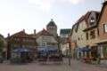
Market place of Bischofsheim
-

Tower „Zentturm“
-
_9596.jpg)
Crosses on the Kreuzberg
Born in Bischofsheim

Johann Joseph von Prechtl around 1815
- Johann Joseph von Prechtl (1778-1854), Austrian technical researcher
- Hans Schlenck (1901-1944), German stage and film actor, theater director
- Hermann Hartmann (1914-1984), German chemist
References
- ↑ "Fortschreibung des Bevölkerungsstandes". Bayerisches Landesamt für Statistik und Datenverarbeitung (in German). June 2016.
External links
This article is issued from Wikipedia - version of the 11/3/2016. The text is available under the Creative Commons Attribution/Share Alike but additional terms may apply for the media files.