Birmingham, Huntingdon County, Pennsylvania
| Birmingham, Huntingdon County, Pennsylvania | |
|---|---|
| Borough | |
|
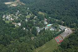
Grier School and the Borough of Birmingham | |
 Birmingham, Huntingdon County, Pennsylvania | |
| Coordinates: 40°38′50″N 78°11′43″W / 40.64722°N 78.19528°WCoordinates: 40°38′50″N 78°11′43″W / 40.64722°N 78.19528°W | |
| Country | United States |
| State | Pennsylvania |
| County | Huntingdon |
| Settled | 1797 |
| Incorporated | 1828 |
| Government | |
| • Type | Borough Council |
| • Mayor | David Pryor (R) |
| Area | |
| • Total | 0.1 sq mi (0.3 km2) |
| Elevation | 1,020 ft (310 m) |
| Population (2010) | |
| • Total | 90 |
| • Density | 900.0/sq mi (347.5/km2) |
| Time zone | Eastern (EST) (UTC-5) |
| • Summer (DST) | EDT (UTC-4) |
| Zip code | 16686 |
| Area code(s) | 814 |
| School District: | Tyrone Area School District |
| Local phone exchanges: 682, 684, 686 | |
Birmingham is a borough in Huntingdon County, Pennsylvania, United States. The population was 90 at the 2010 census. Birmingham is the site of the Birmingham Window, a geologic structure created by a Paleozoic thrust fault. Birmingham's early settler, John Cadwallader, settled on a hill above the Little Juniata River and made plans to establish a large city. Legend among the local residents is that it was once in consideration to be the state capital. In the first several decades of the 19th century, the village grew quickly as a hub for commerce being carried on the Little Juniata River and on the nearby Pennsylvania Canal. By 1850, the Pennsylvania Railroad had passed through the valley. The development of the railroad diminished the importance of Birmingham as a trading hub since the railroad's nearby hubs in Tyrone and Altoona grew quickly on land that was better suited for development.
In 1853, the Mountain Female Seminary opened in Birmingham as a boarding school for girls. In its earliest years, the school benefited from the ease of transportation afforded by the passage of the Pennsylvania railroad through Birmingham. Currently, the school still operates as Grier School, a boarding school for girls.
The East Coast earthquake on August 23, 2011 caused a rockslide along Route 453 in Birmingham.[1]
Geography
Birmingham is located at 40°38′50″N 78°11′43″W / 40.64722°N 78.19528°W (40.647275, -78.195181).[2]
According to the United States Census Bureau, the borough has a total area of 0.1 square miles (0.26 km2), all of it land.
Demographics
| Historical population | |||
|---|---|---|---|
| Census | Pop. | %± | |
| 1820 | 43 | — | |
| 1840 | 235 | — | |
| 1850 | 266 | 13.2% | |
| 1860 | 221 | −16.9% | |
| 1870 | 263 | 19.0% | |
| 1880 | 231 | −12.2% | |
| 1890 | 225 | −2.6% | |
| 1900 | 240 | 6.7% | |
| 1910 | 196 | −18.3% | |
| 1920 | 197 | 0.5% | |
| 1930 | 191 | −3.0% | |
| 1940 | 198 | 3.7% | |
| 1950 | 178 | −10.1% | |
| 1960 | 136 | −23.6% | |
| 1970 | 115 | −15.4% | |
| 1980 | 121 | 5.2% | |
| 1990 | 109 | −9.9% | |
| 2000 | 91 | −16.5% | |
| 2010 | 90 | −1.1% | |
| Est. 2015 | 89 | [3] | −1.1% |
| Sources:[4][5][6] | |||
As of the census[5] of 2010, there were 90 people and 42 households within the borough. The population density was 900.0 people per square mile (585.6/km²). There were 45 housing units at an average density of 450.0 per square mile (283.1/km²). The racial makeup of the borough was 97.78% White, 1.11% Asian, 1.11% from other races. Hispanic or Latino of any race made up 6.67% of the population.
There were 39 households, out of which 19.0% had children under the age of 18 living with them, 51.3% were married couples living together, 10.3% had a female householder with no husband present, and 35.9% were non-families. 33.3% of all households were made up of individuals, and 17.9% had someone living alone who was 65 years of age or older. The average household size was 2.33 and the average family size was 2.92.
In the borough the population was spread out, with 15.6% under the age of 18, 1.1% from 18 to 19, 4.4% from 20 to 24, 12.2% from 25 to 34, 28.9% from 35 to 49, 17.8% from 50 to 64, and 20.0% who were 65 years of age or older. The median age was 40 years. Males made up 48.89% of the population, and females make up 51.11%.
-
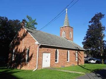
Presbyterian Church
-

Two stone houses
References
- ↑ http://www.altoonamirror.com/page/content.detail/id/552932/Earthquake-centered-in-Va--rolls---.html
- ↑ "US Gazetteer files: 2010, 2000, and 1990". United States Census Bureau. 2011-02-12. Retrieved 2011-04-23.
- ↑ "Annual Estimates of the Resident Population for Incorporated Places: April 1, 2010 to July 1, 2015". Retrieved July 2, 2016.
- ↑ "Census of Population and Housing". U.S. Census Bureau. Archived from the original on 11 May 2015. Retrieved 11 December 2013.
- 1 2 "American FactFinder". United States Census Bureau. Archived from the original on 2013-09-11. Retrieved 2008-01-31.
- ↑ "Incorporated Places and Minor Civil Divisions Datasets: Subcounty Resident Population Estimates: April 1, 2010 to July 1, 2012". Population Estimates. U.S. Census Bureau. Archived from the original on 17 June 2013. Retrieved 11 December 2013.
Municipalities and communities of Huntingdon County, Pennsylvania, United States | ||
|---|---|---|
| Boroughs | 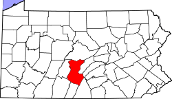 | |
| Townships | ||
| CDPs | ||
| Unincorporated communities | ||