Birkby, North Yorkshire

Coordinates: 54°24′55″N 1°29′15″W / 54.4153°N 1.4875°W
Birkby is a village and civil parish about 6 miles north of the county town of Northallerton in the Hambleton district of North Yorkshire, England. The population of the parish was estimated at 40 in 2010.[1] At the 2011 Census the population was seen to have remained at less than 100. Details were included in the neighbouring civil parish of Deighton, Hambleton.
History
The village is mentioned in the Domesday Book as Bergbi in the Allerton hundred. Att the time of the Norman invasion the manor was the possession of Earl Edwin, but was subsequently taken by the Crown.[2] The manor followed the descent of the lord of Northallerton, but a mesne lordship was granted to Henry de Farlington. By 1316 the manor was in the possession of John de Lisle and soon after entered the holdings of the Scrope family. By the middle of the 16th century the manor had passed to the Foljambe family and thence by marriages to the Grimston's, who were still in possession of the titles in 1821.[3][4]
The etymology of the name of the village is derived from the combination of the Old Norse personal name Bretar and the suffix '-byto give the meaning Bretar's farm.[5][6]
There are the foundations of a medieval settlement opposite the rectory near Hill Top Farm that shows the outline of associated fields that may have been moated with fishponds.[7]
Governance
The village lies within the Richmond UK Parliament constituency. It also lies within the Swale electoral division of North Yorkshire County Council and the Cowtons ward of Hambleton District Council.[8]
Geography
The village lies very close to the East Coast Main Line and on a minor road that runs between East Cowton and the A167. The nearest settlements to Birkby are Little Smeaton, 1.2 miles (1.9 km) to the north-east, Hutton Bonville 1.5 miles (2.4 km) to the south-east and East Cowton 1.5 miles (2.4 km) to the north-west.[8]
Religion
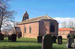
St Peter's church in Birkby dates from 1776. During some 19th-century renovation work the bases of two Norman columns were discovered under the floor of the chancel and others were found under the nave. They had seemed to form part of a much earlier and more ornate building than the one that now occupies the site. Part of the shaft of a Saxon cross was also unearthed, and is now built into the wall of the west end. Adjacent to the church is a rectory.
References
- ↑ "Population Estimates". North Yorkshire County Council. 2010. Retrieved 27 June 2013.
- ↑ Birkby in the Domesday Book. Retrieved 30 May 2013.
- ↑ "History". Retrieved 28 May 2013.
- ↑ Bulmer's Topography, History and Directory (Private and Commercial) of North Yorkshire 1890. S&N Publishing. 1890. pp. 371–372. ISBN 1-86150-299-0.
- ↑ Watts (2011). Cambridge Dictionary of English Place-names. Cambridge University Press. p. 54. ISBN 978-0521168557.
- ↑ A.D. Mills (1998). Dictionary of English Place-Names. Oxford Paperbacks. p. 59. ISBN 978-0192800749.
- ↑ "Ancient Monument". English Heritage. Retrieved 30 May 2013.
- 1 2 Ordnance Survey Open Viewer
![]() Media related to Birkby, North Yorkshire at Wikimedia Commons
Media related to Birkby, North Yorkshire at Wikimedia Commons