Binic
| Binic Binig | ||
|---|---|---|
|
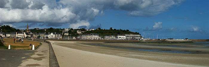
Main quay | ||
| ||
 Binic | ||
|
Location within Brittany region  Binic | ||
| Coordinates: 48°36′09″N 2°49′27″W / 48.6025°N 2.8242°WCoordinates: 48°36′09″N 2°49′27″W / 48.6025°N 2.8242°W | ||
| Country | France | |
| Region | Brittany | |
| Department | Côtes-d'Armor | |
| Arrondissement | Saint-Brieuc | |
| Canton | Plouha | |
| Area1 | 5.96 km2 (2.30 sq mi) | |
| Population (2008)2 | 3,528 | |
| • Density | 590/km2 (1,500/sq mi) | |
| Time zone | CET (UTC+1) | |
| • Summer (DST) | CEST (UTC+2) | |
| INSEE/Postal code | 22007 / 22520 | |
| Elevation | 0–86 m (0–282 ft) | |
|
1 French Land Register data, which excludes lakes, ponds, glaciers > 1 km² (0.386 sq mi or 247 acres) and river estuaries. 2 Population without double counting: residents of multiple communes (e.g., students and military personnel) only counted once. | ||

.svg.png)

Binic (Breton: Binig, Gallo: Binic) is a former commune in the Côtes-d'Armor department of Brittany in north-western France.
It is about 10 km north of Saint-Brieuc. Its beaches have become clogged with sea lettuce.[1]
History
Binic derives its name from the prefix pen (meaning Chief) and Ic which is the name of the nearby river which empties into the sea. Binic is the mouth of Ic. It's called the City of spray or more recently called The Beauty Spot of the Cotes d'Armor.
The story of Binic goes back to the Neolithic (between 3500 and 1800 BC.). Indeed, we discover some megalithic monuments such as the dolmen of Margot's Table (destroyed in 1816 work, at the port).
In the Middle Ages, Binic (then called Benic) was a small village with no more than twenty houses. But it was nevertheless a great venue for fairs and markets where peoples came from surrounding villages.
In 1821 by François Le Saulnier de Saint Jouan, a Binic's shipowner, and with the support of the Duchess of Angoulême (1778-1851), daughter of Louis XVI, Binic becomes a town full of standing out in the parish of Étables-sur-Mer. There is then 1611 inhabitants. It was not until 1840 that the boundaries between Binic and municipalities of Étables-sur-Mer and Pordic were finalized.
In the 19th century, Binic flourished and becomes, in 1845, the leading French port for Great Fishing. The port annually received 150 to 160 ships and the activity was divided between fishing in Newfoundland and cabotage (imported salt, wine, wood North, flour and vegetables). Binic was then the biggest port of Cod fishing.
The period of the first quarter of the 20th century to the threshold of the 1930s, is for the municipality the time for a mutation in depth because the activity of the cod fishery in Newfoundland and Iceland saw as well as its evil past decades.
Faced during the war on German submarines, the rising costs of weapons and fishing regulations more stringent, including Iceland, in 1920 and the competition of steam trawlers, schooners that since the 1860s were emblematic of ports Goelo eventually disappear.
For the port a very bleak beginning. It lasted thirty years.
More recently developed, fisheries in the Scallop, specialty of Saint-Brieuc Bay. Since 1992, Binic trawlers unload their catch to the new port of Saint-Quay-Portrieux, a town close to 6 kilometers.
Between 1906 and 1956 Binic was served by the Railway department of Côtes-du-Nord (renamed Côtes-d'Armor in 1990) and took his station on the esplanade of the Banche, vast space filled and won the strike also built for this purpose by the 'engineer Briochain Louis Auguste Harel of Noah.
The railroad has left important traces Binic: These include two viaducts (Viaduct of Hasée said the Black Dog in front of the WWTP and viaduct Beaufeuillage facing the artisanal zone) located both the along the direction D.4 Lantic.
On 1 March 2016, Binic and Étables-sur-Mer merged becoming one commune called Binic-Étables-sur-Mer.
Population
Inhabitants of Binic are called Binicais in French.
| Historical population | ||
|---|---|---|
| Year | Pop. | ±% |
| 1831 | 1,828 | — |
| 1836 | 2,229 | +21.9% |
| 1841 | 2,324 | +4.3% |
| 1846 | 2,407 | +3.6% |
| 1856 | 2,811 | +16.8% |
| 1861 | 2,673 | −4.9% |
| 1866 | 2,738 | +2.4% |
| 1872 | 3,458 | +26.3% |
| 1876 | 2,457 | −28.9% |
| 1881 | 2,231 | −9.2% |
| 1886 | 2,379 | +6.6% |
| 1891 | 2,222 | −6.6% |
| 1896 | 2,305 | +3.7% |
| 1901 | 2,247 | −2.5% |
| 1906 | 2,231 | −0.7% |
| Historical population | ||
|---|---|---|
| Year | Pop. | ±% |
| 1911 | 2,356 | — |
| 1921 | 2,342 | −0.6% |
| 1926 | 2,223 | −5.1% |
| 1931 | 2,141 | −3.7% |
| 1936 | 2,140 | −0.0% |
| 1946 | 2,241 | +4.7% |
| 1954 | 2,261 | +0.9% |
| 1962 | 2,099 | −7.2% |
| 1968 | 2,212 | +5.4% |
| 1975 | 2,326 | +5.2% |
| 1982 | 2,602 | +11.9% |
| 1990 | 2,798 | +7.5% |
| 1999 | 3,110 | +11.2% |
| 2008 | 3,528 | +13.4% |
| 2010 | 3,693 | +4.7% |
Gallery
.jpg)
See also
References
External links
| Wikimedia Commons has media related to Binic. |
- Official website (French)
- French Ministry of Culture list for Binic (French)