Billmuthausen
Billmuthausen was a village in Germany, founded in 1340. It was destroyed by the East German authorities in 1978 as it stood too close to the Inner German border (part of the larger "Iron Curtain"), the border between the post-war states of East and West Germany. It lay in the extreme south of Thuringia in the Heldburger Land in the district of Hildburghausen, only five hundred meters away from the Thuringian-Bavarian border. In January 1965, the authorities destroyed the small, very old village church. In September 1978, the last family left the village, after which all the buildings in the village were demolished and the land leveled.
History
Billmuthausen is first mentioned in historical records in 1340 under the name of Billmuthehusen and in 1528 under the name of Bylmethausen. In 1840, the village had 14 households, a mill and a church. A decade later, the village's population stood at 68.[1]
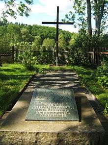
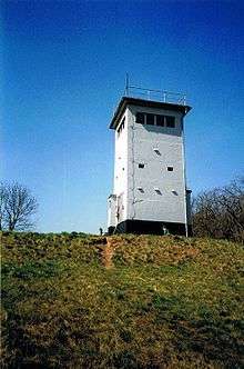
The former site of the village is now a memorial with a marker stone and cross, and a new chapel is located at the site of destroyed church. All that remains is the village cemetery, a transformation tower and the village well. In 1991 the book Billmuthausen-das verurteilte Dorf was published about the village. There is an annual ceremony to commemorate the history of the village.
Bell consecration in 2014
On May 31, 2014, the bells of the razed church rang again at Billmuthausen after having been silent for 50 years. They were consecrated during a solemn ecumenical open-air church service attended by more than 150 participants. The two bronze bells, named Faith and Hope are kept in the Otto-Ludwig-Museum in Eisfeld and are moved to Billmuthausen on portable stands on commemorative occasions.
References
- ↑ Goepfert, Ulrich. "Billmuthausen: From razed village in the lowlands Heldburger". Retrieved 13 August 2013.
- Norbert Klaus Fuchs: Billmuthausen – Das verurteilte Dorf. Greifenverlag zu Rudolstadt & Berlin, 2009, ISBN 978-3-86939-004-8
- Norbert Klaus Fuchs: Das Heldburger Land–ein historischer Reiseführer; Verlag Rockstuhl, Bad Langensalza 2013, ISBN 978-3-86777-349-2
| Wikimedia Commons has media related to Billmuthausen. |
Coordinates: 50°17′N 10°47′E / 50.283°N 10.783°E