Bilberry Hill
| Bilberry Hill | |
|---|---|
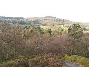 A view from Bilberry Hill over Rosehill Road and the Birmingham Municipal Golf Course towards Beacon Hill. Bilberry bushes can be seen in the foreground. | |
| Highest point | |
| Elevation | 243.8 m (800 ft) |
| Prominence | 99 m (325 ft) |
| Listing | Marilyn |
| Geography | |
| Location | Worcestershire, U.K. |
| Parent range | Lickey Hills |
Bilberry Hill is one of the Lickey Hills in northern Worcestershire, England, 10.3 miles (16.5 kilometres) south west of Birmingham and 24 miles (38.5 kilometres) north east of Worcester. It stands above and to the west of the village of Cofton Hackett, and is part of the Lickey Hills Country Park.
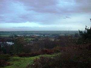
The three hilltops comprising The Lickeys - Bilberry Hill, Rednal Hill and Cofton Hill - form the northern extremity of the Lickey Ridge, a formation of hard quartzite. Views over Birmingham and the surrounding countryside can be seen from the top of these hills.
The hill is named after the tracts of Bilberry (Vaccinium myrtillus) bushes that cover the hill, between the pathways. Local people have been cropping the bushes of their fruit each autumn for hundreds of years to make jams, preserves or apple and bilberry pies.
History
In 1888 the Birmingham Society for the Preservation of Open Spaces purchased Rednal Hill and handed it to the City in trust. In 1913 they also arranged for Bilberry Hill and Pinfold Wood to be leased to the city on a nominal peppercorn rent in perpetuity. Birmingham City Council finally purchased Cofton Hill, Lickey Warren and Pinfield Wood outright in 1920. With the eventual purchase of the Rose Hill Estate from the Cadbury family in 1923, free public access was finally restored to the entire hills with what would become the Lickey Hills Country Park in 1971.
The Bilberry Hill Centre is a hostel and sports facility run by Birmingham Clubs for Young People nestling at the base of Bilberry Hill, in a building that was donated to the people of Birmingam by Mr and Mrs Barrow Cadbury in 1904 as the Lickey Tea Rooms and remained in use as a restaurant until the early 1960s. The hostel can accommodate up to 65 persons.[1] In the winter of 2008 the centre is under threat of imminent closure over funding issues and there is an internet campaign to save the facility for future use by young people.[2]
Geology
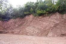
The Lickey Hills area is of significant geological interest due to the range and age of the rocks. The darker quartzite making up Bilberry Hill shows signs of having been deposited as sand at the bottom of a shallow sea.The stratigraphic sequence, which is the basis for the area's diversity of landscape and habitat, comprises:[3]
- Barnt Green rocks - tuffs and volcanic grits siltstones and mudstones from the Tremadocian stage of the Ordovician[4]
- Lickey Quartzite - an Ordovician quartzite with thin beds of mudstone and possibly tuff[5]
- Halesowen Formation - a Carboniferous mudstone of Westphalian D age[6]
- Clent Formation - a breccia of lower Permian age[7]
- Bunter Pebble Beds - beds of Triassic water-worn pebbles
The soil is marl and the subsoil gravel, sand and clay. There is a small quarry where Wenlock limestone was worked at the time of the making of the Worcester and Birmingham Canal, and there are some gravel-pits.
See also
References
- ↑ Bilberry Hill Centre
- ↑ Save the Bilbury Hill Centre
- ↑ Birmingham City Council. "Lickey Hills Country Park: Geology". Retrieved 27 March 2010.
- ↑ British Geological Survey. "Barnt Green Volcanic Formation". The BGS Lexicon of Named Rock Units. Retrieved 4 January 2012.
- ↑ British Geological Survey. "Lickey Quartzite Formation". The BGS Lexicon of Named Rock Units. Retrieved 4 January 2012.
- ↑ British Geological Survey. "Halesowen Formation". The BGS Lexicon of Named Rock Units. Retrieved 4 January 2012.
- ↑ British Geological Survey. "Clent Formation". The BGS Lexicon of Named Rock Units. Retrieved 4 January 2012.
- Margaret Mabey, A Little History of the Lickey Hills, The Lickey Hills Society, 1993, ISBN 0-9519839-1-1
- Around Rubery and The Lickey Hills compiled by Martin Hampson. From the Images of England Series published by Tempus Publishing Limited 2000. ISBN 0-7524-2097-6
External links
Coordinates: 52°22′36″N 2°00′37″W / 52.37664°N 2.01024°W