Bikar Atoll
|
Map of Bikar Atoll | |
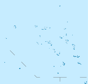 Bikar Atoll Bikar Atoll (Marshall islands) | |
| Geography | |
|---|---|
| Location | North Pacific |
| Coordinates | 12°14′N 170°08′E / 12.233°N 170.133°E |
| Archipelago | Marshall Islands |
| Total islands | 6 |
| Major islands | 5 |
| Area | 0.5 km2 (0.19 sq mi) |
| Highest elevation | 6 m (20 ft) |
| Administration | |
| Demographics | |
| Population | 0 |
.jpg)
Bikar Atoll (Marshallese: Pikaar, [pʲi͡ɯɡɑːrˠ][1]) is an uninhabited atoll in the Ratak Chain of the Marshall Islands. It is one of the smallest atolls in the Marshalls and located at 12°14′N 170°08′E / 12.233°N 170.133°E. Due to its relative isolation from the main islands in the group, Bikar has a largely undisturbed flora and fauna that has been allowed to exist in a relatively pristine condition.
Geography
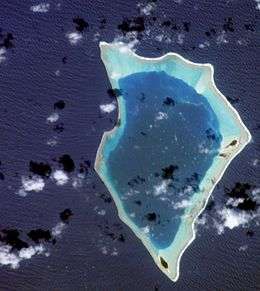
It is located 579 kilometres (360 mi) north of Majuro Atoll, the capital of the Marshall Islands, 320 kilometres (200 mi) South-southeast of Bokak, and 115 kilometres (71 mi) north of Utirik, the nearest inhabited atoll. The land area is 0.5 square kilometres (0.19 sq mi), surrounding a 37.4-square-kilometre (14.4 sq mi) lagoon. It consists of 6 islets.[2]
Physical features
The approximately diamond-shaped atoll measures up to 13 km north to south and up to 8 km across. Its six islets have a combined land area of less than 0.5 square kilometres (0.19 sq mi) and enclose a shallow lagoon of 37 square kilometres (14 sq mi). The surrounding reef is continuous except for one narrow pass located on the western side. The major islets are Bikar, Jabwelo, Almani and Jaboero. Bikar, the largest, reaches a height of 6 meters above sea level.[3]
Based on the results of drilling operations on Enewetak (Eniwetok) Atoll, in the nearby Ralik Chain of the Marshall Islands, Bikar may include as much as 4600 feet of reef material atop a basalt rock base. As most local coral growth stops at about 150 feet below the ocean surface, such a massive stony coral base suggests a gradual isostatic subsidence of the underlying extinct volcano,[4] which itself rises 10,000 feet from the surrounding ocean floor. Shallow water fossils taken from just above Enewetak's basalt base are dated to about 55 mya.[5]
Low rainfall and high temperatures lead to arid conditions in which a fresh water Ghyben-Herzberg lens cannot form. The water at Bikar island is not as brackish as similarly arid Taongi Atoll, allowing coconuts planted by visiting islanders from Utirik Atoll to survive.
Like Taongi Atoll, the combination of an almost completely enclosed lagoon and waves driven over the reef by the prevailing northeastern trade winds results in the water level being perched some 0.5 m above the mean tide level.[3]
Climate
Bikar is one of the driest of the Marshall Islands atolls, having a semi-arid character. Mean annual temperature is approximately 82 °F (28 °C). Mean annual rainfall is less than 45 inches (1,143 mm), and falls primarily during the July through October rainy season. Prevailing winds are north to north-easterlies.
Vegetation
Plant species of atoll forest include Pandanus tectorius, Lepturus repens, Cocos nucifera, Boerhavia repens, Pisonia grandis, Portulaca lutea, Triumfetta procumbens,[6] Tournefortia argentea and Scaevola sericea, as well as areas of atoll scrub and vines.[7] Much of the Pisonia forest noted in earlier surveys was devastated by a cyclone, perhaps Typhoon Mary in 1977.[8] This is likely a naturally recurring event.[3][9] A small number of coconut palms planted by visiting islanders survive. A 1952 survey found that they produced small nuts containing bitter milk.[10]
Fauna
Bikar's status as a major seabird nesting site was affected by a cyclone and the introduction of more aggressive rat species.[7]
Twenty-three species of birds were found in a 1969 survey, of which 19 were observed during a follow-up count in 1988. Species breeding in larger numbers that year included the great frigatebird and red-footed booby. Their numbers appear reduced due to the destruction of the Pisonia forests. Other breeding species include the red-tailed tropicbird, white-tailed tropicbird, the masked booby, brown booby, white tern, brown noddy, and sooty tern.
Migrant birds include small numbers of the ruddy turnstone, wandering tattler, bristle-thighed curlew, lesser golden plover, and Pacific reef heron.[3]
Bikar is also a major nesting site for the endangered green turtle, over 250 nesting sites having been observed in 1988.[7]
The Polynesian rat is common on Bikar and Jabwelo.[3] By 1993, a "population explosion" of non-Polynesian rats had been noted on the atoll, most likely introduced by Asian fishing trawlers operating illegally in the vicinity of Bikar. This raised concerns for the important sea turtle and bird nesting sites.[11]
The coral fauna lacks diversity and shows signs of frequent storm damage. The corals include several genera not seen at Taongi Atoll, and the diversity of fish is much greater, including the two-spot red snapper, humpback red snapper, leopard grouper, and humphead parrot fish.
Shellfish include the black-lipped pearl oyster, bear paw clam, maxima clam, and the Trochus sea snail. No marine mammals have been seen in the lagoon.[3]
History
Prehistory
Although humans migrated to the Marshall Islands about 2000 years ago,[12] and Bikar was occasionally visited by the Marshallese, there is no evidence that there has ever been a resident human population. The lack of water and the susceptibility of the atoll to cyclone and storm disturbance indicate that it will probably remain uninhabited. The atoll has traditionally been used for hunting and gathering, particularly seabirds and turtles, by inhabitants of other atolls in the northern Ratak chain.[13] Along with the other uninhabited northern Ratak atolls of Bokak (Taongi) and Toke, Bikar was traditionally the hereditary property of the Ratak atoll chain Iroji Lablab. The exploitation of abundant sea turtles, birds, and eggs was regulated by custom, and overseen by the Iroji.[14]
19th century
The Russian brig Rurik, with Captain Otto von Kotzebue, visited in summer 1817 during a search for a north passage between western Russia and its North American territories.[15]
The French corvette Danaide, Capt J. de Rosamel, visited the atoll in August 1840 during a hydrographical survey of islands in the Pacific.[16][17]

During the late 1800s, Bikar was the subject of a number of commercial transactions related to the increasing German presence in the Marshall Islands. On January 12, 1880 Bikar was sold by Iroojs Jurtaka and Takular of Maloelap, and on June 19, sold by Irooj Lajikit and Tannara of Utirik to Adolph Capelle & Co. On December 18, 1883 the Atoll was sold to Deutsche Handels und Plantagengesellschaft. Spain transferred sovereignty to the Empire of Germany in 1885, and in December, 1887 property rights were transferred to the Jaluit Gesellschaft.[18]
In 1900, the Manchester, a four masted steel hulled cargo ship of 2851 tons with a load of kerosene, went missing at sea between New York City and Yokohama. Wreckage and signs of habitation were discovered on Bikar in 1901, suggesting that the ship had come to grief there, and that the survivors had pushed off in lifeboats shortly before the discovery. No sign of the crew or passengers has since been found.[19]
20th century to present
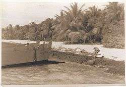
In 1914, the Empire of Japan occupied the Marshall Islands, and transferred German government properties to their own, including Bikar. Like the Germans before them, the Japanese colonial administration (the South Pacific Mandate) did not attempt to exploit the atoll, and the Northern Radak Marshallese continued to hunt and fish unmolested.[20] Following the end of World War II, the island came under the control of the United States as part of the Trust Territory of the Pacific Islands. In 1951, the U.S. Geological Survey and the Army Corps of Engineers sponsored an expedition to Bikar and Taongi Atolls, to characterize their primeval environment.[21]
While en route from the US to Asia in April, 1953, LST 1138, later commissioned as USS Steuben County, dropped anchor at Bikar to search for rumored Japanese stragglers. The landing party found no signs of any current occupants.[22]
In 1954, the fallout plume from the Castle Bravo nuclear test passed over Bikar about 20 hours after the shot. Based on ash from plant samples taken on March 9, the atoll was contaminated by about 1,400,000 d/m/gm of radioactive material, compared with 35,000,000 d/m/gm from the most contaminated soil samples at Rongelap Atoll, and 950 d/m/gm at Majuro Atoll, several hundred miles south of the fallout pattern. This experience led to a pre-planned aerial survey of atolls adjacent to the subsequent March 27 Castle Romeo test, timed at one and four hours after the shot. The aircraft were equipped with gamma radiation detectors designed to measure ground contamination from altitudes of 200 to 500 feet. An overflight of Bikar Island measured 0.1 mrem/hr (1 μGy) an hour after the shot, rising to 15 mrem/hr (150 μGy) three hours later.[23]

In 1962, 19 Japanese fishermen from the fishing boat Daitei Maru No. 15 were marooned on Bikar Atoll for several days before being rescued by the U.S. Coast Guard.[24]
A 1981 study of fish and invertebrates within the lagoon found that the level of radio-nucleotides in muscle tissue was within the range found in fish products imported to the US and Japanese markets. The worldwide source of seafood-borne radio-nucleotides is a result of atmospheric nuclear testing since 1945, and therefore any residual activity from the 1950s Castle series of tests contributes only a small fraction of the contamination within the lagoon's sea life.[25]
Currently, no archaeological remains of Polynesian habitation have been identified. The almost completed corroded wreck of a Japanese fishing boat lies in the north fork of the reef passage.[3]
| Wikimedia Commons has media related to Bikar Atoll. |
Footnotes
- ↑ Marshallese-English Dictionary - Place Name Index
- ↑ Marshall Islands Atoll Information
- 1 2 3 4 5 6 7 United Nations Environment Programme
- ↑ Geoscience Research Institute
- ↑ Atoll Research Bulletin No. 260
- ↑ USDA Natural Resources Conservation Service
- 1 2 3 The Island Encyclopedia
- ↑ (See Typhoon Mary (1977))
- ↑ Spennemann, Marschner
- ↑ Vegetation of the Tropical Pacific Islands
- ↑ Earthweek
- ↑ University of California, Berkeley
- ↑ UNEP
- ↑ Atoll Research Bulletin No. 11
- ↑ The Romanzov Exploring Expedition
- ↑ Ships visiting the Marshall Islands (until 1885)
- ↑ Voyage De Circumnavigation De La Danaïde
- ↑ Foreign Land holdings in the German Marshall Islands
- ↑ Grim Signs Of Shipwreck
- ↑ Atoll Research Bulletin 11
- ↑ Expedition Will Explore 'Robinson Crusoe' Islands
- ↑ C.D. Pardee
- ↑ Department of Health, Safety, and Security , DOE
- ↑ Boat Missing
- ↑ Department of Health, Safety, and Security , DOE
References
- Spennemann, Dirk H.R. (2000). "Marshall Islands Atoll Information, Bikar". Digital Micronesia. Albury NSW 2640, Australia: Institute of Land, Water and Society, Charles Sturt University. Archived from the original on 26 March 2009. Retrieved 2009-04-26.
- "2008 World Database on Protected Areas". United Nations Environment Programme (UNEP), World Conservation Monitoring Centre. 2009-04-25.
- "USDA Plants Database". USDA Natural Resources Conservation Service.
- Dieter Mueller-Dombois; Francis Raymond Fosberg (1998). Vegetation of the Tropical Pacific Islands. Springer. p. 306. ISBN 0-387-98313-9.
- Spennemann, Dirk H.R. (2000). "Stormy Years: On the Association between the El Niño phenomenon and the occurrence of typhoons in the Marshall Islands". Digital Micronesia. Albury NSW 2640, Australia: Institute of Land, Water and Society, Charles Sturt University. Archived from the original on 26 March 2009. Retrieved 2009-04-26.
- "Coral Reef Growth". Geoscience Research Institute. 1979-01-01.
- "Atoll Research Bulletin No. 260". 1983. hdl:10088/5039.
- "Bikar Atoll". The Island Encyclopedia. oceandots.com. Archived from the original on December 23, 2010. Retrieved 2009-05-27.
- Patrick V. Kirch. "Introduction to Pacific Islands Archaeology". Archaeological Research Facility, University of California, Berkeley, CA, USA. Retrieved 2010-06-04.
- "Atoll Research Bulletin No. 11, Land Tenure in the Marshall Islands". Smithsonian National Museum of Natural History. 1952-09-01. hdl:10088/5075.
- Adelbert von Chamisso (1986). A voyage around the world with the Romanzov exploring expedition in the years 1815-1818 in the brig Rurik, Captain Otto von Kotzebue. Translated by Henry Kratz. University of Hawaii Press. p. 157. ISBN 0-8248-0983-1.
- Spennemann, Dirk H.R. (2000). "Ships visiting the Marshall Islands (until 1885)". Digital Micronesia. Albury NSW 2640, Australia: Institute of Land, Water and Society, Charles Sturt University. Archived from the original on 26 March 2009. Retrieved 2009-04-26.
- De Rosamel, Capitaine De Corvette Joseph. Pohnpei, Micronésie, en 1840 : voyage de circumnavigation de la Danaïde. ISBN 2-85430-009-2.
- Spennemann, Dirk H.R. (2000). "Foreign Land holdings in the German Marshall Islands". Digital Micronesia. Albury NSW 2640, Australia: Institute of Land, Water and Society, Charles Sturt University. Archived from the original on 26 March 2009. Retrieved 2009-04-26.
- "Grim Signs Of Shipwreck". The Republican. Estherville, IA, USA: Jenkins & Nichols. Japan Daily Mail. 7 November 1901. p. 1. Retrieved 2009-04-25.
News comes from Australia of the finding on Bikar island, a small uninhabited atoll of the Marshall group, of wreckage which is thought to indicate that the British ship Manchester came to grief there.
- "Expedition Will Explore 'Robinson Crusoe' Islands". Herald-American. Syracuse, NY, USA. NANA. 25 November 1951. p. 8. Retrieved 2009-04-26.
- "Reports On Evacuation Of Natives And Surveys Of Several Marshall Island Atolls" (PDF). Department of Health, Safety, and Security , DOE. 1954-05-24. Archived from the original (PDF) on 2011-07-21.
- "Northern Marshall Island Rad Survey: Radionuclide Concentrations in Fish and Clams and Estimated Doses via the Marine Pathway". Department of Health, Safety, and Security , DOE. 1981-08-18.
- " "Boat Missing". Free Press. Winnipeg: Clifford Sifton. AP. 5 February 1962. p. 9. Retrieved 2009-04-26.
A U.S. Navy plane sighted 19 Japanese fishermen on Bikar Island in the Marshall Islands Sunday.
- "Earthwatch". The Intelligencer, Doylestown, PA, May 2, 1993.
- "LST 1138 aka USS STEUBEN COUNTY, Years 1952-1955". C.D. Pardee. 2007-07-11.
- Ben M. Cahoon. "WorldStatesmen.org, Marshall Islands".
External links
- UNEP Protected Areas Program Profile
- Atoll Research Bulletin Archive Home Page
- U.S. Dept. of Energy OPENnet advanced search page, (search full text field on string "Bikar").
- Plants in the Marshall Islands, A Photo Essay
- Sailing Ship: Manchester (1892-1900)
- Miramar Ship Index: Manchester
- Video: Bikar Atoll Pass Via Dinghy
| ||
| Ratak Chain (Sunrise, Eastern) |  | |
| Ralik Chain (Sunset, Western) | ||