Bihor County
| Bihor County Județul Bihor | ||
|---|---|---|
| County | ||
| ||
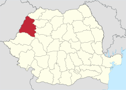 Location of Bihor County in Romania | ||
| Country |
| |
| Historic region | Crișana | |
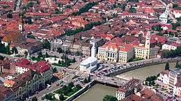
| Capital city (Reședință de județ) | Oradea | |
| Government | ||
| • Type | County Board | |
| • President of the County Board | Sándor Pásztor (UDMR) | |
| • Prefect2 | Claudiu Pop | |
| Area | ||
| • Total | 7,544 km2 (2,913 sq mi) | |
| Area rank | 6th in Romania | |
| Population (2011 census[1]) | ||
| • Total | 575,398 | |
| • Rank | 11th in Romania | |
| • Density | 76/km2 (200/sq mi) | |
| Time zone | EET (UTC+2) | |
| • Summer (DST) | EEST (UTC+3) | |
| Postal Code | 41wxyz3 | |
| Area code(s) | +40 x594 | |
| Car Plates | BH5 | |
| GDP | US$ 5.82 billion (2008) | |
| GDP/capita | US$ 9,708 (2008) | |
| GDP/capita at purchasing power parity | US$ 17,152 (2009) | |
| Website |
County Board County Prefecture | |
|
1The developing regions of Romania have no administrative role. They were formed to attract funds from the European Union 2 as of 2007, the Prefect is not a politician, but a civil servant. He (or she) is not allowed to be a member of a political party, and is banned from any political activity in the first six months after the resignation (or firing) from the civil service 3w, x, y, and z are digits that indicate the city, the street, part of the street, or even the building of the address 4x is a digit indicating the operator: 2 for the former national operator, Romtelecom, and 3 for the other ground telephone networks 5used on both the plates of the vehicles that operate only in the county limits (like utility vehicles, ATVs, etc.), and the ones used outside the county | ||
Bihor (Romanian pronunciation: [biˈhor]) is a county (județ) of Romania, in Crișana, with capital city at Oradea.
Name
Bihor
Demographics
In 2002, Bihor had a population of 600,246 and the population density was 79.56/km². 48.6% of its population lives in urban areas, lower than the Romanian average.[2][3]
- Romanians - 67.38%
- Hungarians - 25.96%
- Romani - 5.01%
- Slovaks - 1.22%
- Germans - 0.19%
In October 31, 2011, Bihor had a population of 575,398 and the population density was 72/km2 (186/sq mi).<[4]
- Romanians – 66.96%
- Hungarians – 25.27%
- Romani – 6.33%
- Slovaks – 1.1%
- Germans – 0.13%
By religion
99.4% of the county's population are Christian[5] and of these:
- Romanian Orthodox – 59.7%
- Reformed – 18.1%;
- Catholic – 11.5% (Roman Catholic – 9.2%; Greek Catholic – 2.3%)
- Pentecostal – 5.7%;
- Baptists – 3.7%;
- Adventist – 0.3%;
| Year | County population[6] |
|---|---|
| 1948 | 536,323 |
| 1956 | |
| 1966 | |
| 1977 | |
| 1992 | |
| 2002 | |
| 2011 |
Geography
This county has a total area of 7,544 km2 (2,913 sq mi). In the East side of the County there are the Apuseni Mountains with heights up to 1,800 m (5,906 ft). The heights decrease westwards, passing through the hills an ending in the Romanian Western Plain – the eastern side of the Pannonian plain.
The county is mainly the Criș hydrographic basine with the rivers Crișul Repede, Crișul Negru and Barcău the main rivers.
Neighbours

- Sălaj County, Cluj County and Alba County in the East.
- Hungary in the West – Hajdú-Bihar County.
- Satu Mare County in the North.
- Arad County in the South.
Economy
Bihor is one of the wealthiest counties in Romania, with a GDP per capita well above the national average. Recently, the economy has been driven by a number of construction projects. Bihor has the lowest unemployment rate in Romania and among the lowest in Europe, with only 2.4% unemployment, compared to Romania's average of 5.1%.
The predominant industries in the county are:
- Textile industry.
- Food and beverages industry.
- Mechanical components industry.
- Metallurgy.
In the west side of the county there are mines for extracting coal and bauxite. Crude oil is also extracted.
Tourism
The main tourist attractions in the county are:
- The city of Oradea.
- The Apuseni Mountains:
- The Stâna de Vale Resort and the Iada valley.
- The Caves around Padiș and on the Sighiștel River Valley.
- The Bear's Cave.
- Băile Felix Resort.
Politics
The Bihor County Council, elected at the 2016 local government elections, is made up of 35 counselors, with the following party composition:[7]
| Party | Seats | Current County Council | |||||||||||||||||
|---|---|---|---|---|---|---|---|---|---|---|---|---|---|---|---|---|---|---|---|
| National Liberal Party | 17 | ||||||||||||||||||
| Social Democratic Party | 9 | ||||||||||||||||||
| Democratic Alliance of Hungarians | 7 | ||||||||||||||||||
| Alliance of Liberals and Democrats | 2 | ||||||||||||||||||
Administrative divisions
Bihor County has 4 municipalities, 6 towns and 91 communes.
- Municipalities
- Towns
- Communes
- Abram
- Abrămuț
- Aștileu
- Aușeu
- Avram Iancu
- Balc
- Batăr
- Biharia
- Boianu Mare
- Borod
- Borș
- Bratca
- Brusturi
- Budureasa
- Buduslău
- Bulz
- Buntești
- Căbești
- Câmpani
- Căpâlna
- Cărpinet
- Cefa
- Ceica
- Cetariu
- Cherechiu
- Chișlaz
- Ciumeghiu
- Cociuba Mare
- Copăcel
- Criștioru de Jos
- Curățele
- Curtuișeni
- Derna
- Diosig
- Dobreşti
- Drăgănești
- Drăgești
- Finiș
- Gepiu
- Girișu de Criș
- Hidişelu de Sus
- Holod
- Husasău de Tinca
- Ineu
- Lăzăreni
- Lazuri de Beiuș
- Lugașu de Jos
- Lunca
- Mădăras
- Măgești
- Nojorid
- Olcea
- Oșorhei
- Paleu
- Pietroasa
- Pocola
- Pomezeu
- Popești
- Răbăgani
- Remetea
- Rieni
- Roșia
- Roșiori
- Sâmbăta
- Sâniob
- Sânnicolau Român
- Sânmartin
- Sântandrei
- Sârbi
- Săcădat
- Sălacea
- Sălard
- Spinuș
- Suplacu de Barcău
- Șimian
- Șinteu
- Șoimi
- Șuncuiuș
- Tămășeu
- Tărcaia
- Tarcea
- Tăuteu
- Tileagd
- Tinca
- Toboliu
- Tulca
- Țețchea
- Uileacu de Beiuș
- Vadu Crișului
- Vârciorog
- Viișoara
References
| Wikimedia Commons has media related to Bihor County. |
- ↑ "Population at 20 October 2011" (in Romanian). INSSE. 5 July 2013. Retrieved 9 July 2013.
- ↑ Romanian 2002 Census
- ↑ National Institute of Statistics, "Populaţia după etnie"
- ↑ Recensamantul Populatiei si Locuintelor 2011: Populația stabilă după etnie – județe, municipii, orașe, comune
- ↑ Romania and Bihor County Census, 2002, (Hungarian)
- ↑ National Institute of Statistics, "Populația la recensămintele din anii 1948, 1956, 1966, 1977, 1992, 2002 și 2011" Archived 22 September 2006 at the Wayback Machine.
- ↑ "Mandate de CJ pe judete si competitori" (in Romanian). Biroul Electoral Central. 10 June 2016. Retrieved 16 June 2016.
Coordinates: 47°04′20″N 21°55′16″E / 47.0722°N 21.9211°E