Białołęka
| Białołęka | |||
|---|---|---|---|
| Dzielnica of Warsaw | |||
|
Światowida street in 2007 | |||
| |||
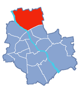 Location of Białołęka within Warsaw | |||
| Coordinates: 52°19′15.60″N 20°58′13.80″E / 52.3210000°N 20.9705000°ECoordinates: 52°19′15.60″N 20°58′13.80″E / 52.3210000°N 20.9705000°E | |||
| Country |
| ||
| Voivodeship | Masovian | ||
| County/City | Warsaw | ||
| Government | |||
| • Mayor | Piotr Jaworski | ||
| Area | |||
| • Total | 73.04 km2 (28.20 sq mi) | ||
| Population (2011) | |||
| • Total | 92,768 | ||
| • Density | 1,300/km2 (3,300/sq mi) | ||
| Time zone | CET (UTC+1) | ||
| • Summer (DST) | CEST (UTC+2) | ||
| Area code(s) | +48 22 | ||
| Website | bialoleka.waw.pl | ||


Białołęka (Polish pronunciation: [bʲawɔˈwɛŋka], from biały - white and łąka - meadow) is one of 18 districts of Warsaw, located in the northern part of the city. Until October 27, 2002 Białołęka was a gmina. The name Białołęka comes from a nobleman Białołęcki, who bought the area before the First World War.
According to the Central Statistical Office data, the district's area is 73.04 square kilometres (28.20 square miles) and 92 768 people inhabit Białołęka.
History
On the fields of Białołęka, one of the battles with the Swedish on July 28–30, 1656 took place. On February 25, 1831 one of the battles of the November Uprising - Battle of Białołęka - took place.
- In 1425, the Białołęka village came into being and belonged to the Gołyński family.
- During the interwar period, only the Różopol subdivision was part of Warsaw.
- In 1938 Białołęka had 900 inhabitants and belonged to the Bródno municipality.
- In 1951 a group of villages (including Białołęka) joined Warsaw as result of the new administrative divisions of Warsaw.
- In 1976, during the next border changes, more villages joined Warsaw and the north-eastern border of Warsaw reached the point where it remains today.
- In 1994, the Białołęka subdivision gave its name to the new gmina Warsaw-Białołęka. The gmina was the third largest out of eleven Warsaw gminas - 15% of the city's area.
- In 2002, the territorial division of Warsaw changed, and gminas were replaced with dzielnicas.
Division
The area of the division is subdivided into following parts:
- industrial, where many industries are located in central, southern and southern-western parts: Żerań CHP Station (Elektrociepłownia Żerań), Polfa Tarchomin (a pharmaceutical company), Czajka sludgeworks, printing site of Agora SA publisher, factories of L'Oréal and the Coca-Cola Company, PKP rail sites, and many building companies
- housing estates with high density housing located in the central-western part (Nowy Tarchomin, Nowodwory and Nowe Świdry)
- housing estates with prevalent detached housing - northern and central-northern parts (Choszczówka, Białołęka Dworska, Płudy, Henryków and others)
- housing estates in village areas and arable lands (Brzeziny, Lewandów, Kobiałka, Białołęka Szlachecka, Mańki-Wojdy and others)
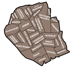
Subdivisions of Białołęka
Białołęka is divided into smaller subdivisions (osiedles). Here's a list of them (the italic names are the ones which are not taken into account by the TERYT).


|
West
|
Middle west
|
Middle east
|
East
|
Other subdivisions:
- Szylówek
Green Białołęka

- Parks:
- Henrykowski Park – 30 056 m²
- "Picassa" Park – 36 700 m²
- Squares
- By Botewa/Talarowa streets – 5088 m²
- Next to Picassa housing estate – 32 900 m²
- Around the town hall – 4560 m²
- By Światowida street – 4600 m²
- Flowerbeds
- Area of flowerbeds – 250 m²
- Area of rose-gardens – 177 m²
- Surface waters
- Vistula river – 10 123 m
- Henrykowski canal – 9638 m
- Żerański canal – 9240 m
- Długa river + Markowski canal – 5450 m
- Bródnowski canal – 3600 m
- Dyke B – 3270 m
- Dyke A – 2640 m
- Jabłonna stream – 1838 m
- Natural reserves
- Ławice Kiełpińskie natural reserve – fauna natural reserve near the border of Warsaw, which function is to protect places where water-mud birds make nests. Area - 803 hectares.
- Łęgi Czarnej Strugi natural reserve – situated in the north-west part of Nieporęt gmina. Area - 39,53 hectares.
There are also many different-sized forests in Białołęka.
Monuments of Białołęka
- Court on Mehoffera Street
- This consists of a court from the 18th century, a palace from the beginning of the 19th century built by Tadeusz Mostowski, and a park.

- Church of St James the Great
- 2 Mehoffera Street
- The Church of St James the Great on Mehoffera Street is the only Gothic temple in Warsaw which still looks nearly the same today as when it was built. The architectural details from 16th century are still visible. The church is built from brick and it dates from the beginning of 16th century.
- Church of Birth of the Blessed Virgin Lady
- 21 Klasyków Street
- A church built from 1908 to 1913 in Vistula Neo-Gothic style. It was consecrated on September 8, 1913, and on September 16, 1949 it was given its name by Stefan Wyszyński.
- Church of Michelangelo
- 119 Głębocka Street
- One of the oldest wooden churches in Warsaw, probably founded by Bona Sforza in 1534.
Transport in Białołęka
The main route where all transport goes is Modlińska Street (an extension of Jagiellońska), which is a part of trunk road 61 to Gdańsk and Masuria; and the Toruńska route, part of trunk road 8 to Białystok. Płochocińska Street is also an important transport route as a fragment of the 633 voivodeship road to Nieporęt.
There are also plans of creating whole-city-long routes including Białołęka's routes:
- Maria Skłodowska-Curie Bridge route
- Vistula route
- Olszynka Grochowska route
- extension of Marywilska Street to the borders of Warsaw
A railroad to Działdowo goes through the district. There are three stops on the railroad, on which Koleje Mazowieckie passenger trains, going from Warszawa Gdańska and Warszawa Wola (now Warszawa Zachodnia's eighth platform) stations, going to Legionowo, Nasielsk, Ciechanów and Działdowo, stop.
In 2013, the first stage of a tram line extension brought the Warsaw tram network to Białołęka with line 2 connecting the area to the Młociny metro station.
Borders
Białołęka borders:
- Targówek to the south along the Toruńska Route
- Bielany and Łomianki to the west across the Vistula
- Jabłonna and Nieporęt to the north
- Marki to the east
External links
| Wikimedia Commons has media related to Białołęka. |