Bhuj
| Bhuj भुज ભુજ | |
|---|---|
| City | |
|
The Prag Mahal | |
 Bhuj | |
| Coordinates: 23°15′N 69°40′E / 23.25°N 69.67°ECoordinates: 23°15′N 69°40′E / 23.25°N 69.67°E | |
| Country |
|
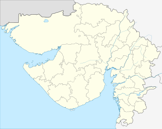
| State | Gujarat |
| District | Kachchh |
| Municipality | Bhuj Municipality |
| Founded by | Rao Hamirji |
| Government | |
| • Type | Municipal corporation |
| Area | |
| • Total | 56 km2 (22 sq mi) |
| Elevation | 110 m (360 ft) |
| Population (2011) | |
| • Total | 148,834 |
| • Density | 2,700/km2 (6,900/sq mi) |
| Languages | |
| • Official | Gujarati |
| Time zone | IST (UTC+5:30) |
| PIN | 370001 |
| Telephone code | 2832 |
| Vehicle registration | GJ-12 |
| Sex ratio | 0.97 ♀/♂ |
| Website | www.gujarattourism.com |
| source:Census of India[1] | |

Bhuj (![]() ) is a city and a Municipality in Kutch District in the state of Gujarat, India.
) is a city and a Municipality in Kutch District in the state of Gujarat, India.
Etymology
According to legend, Kutch was ruled by the Nāga chieftains in past. Sagai, a queen of Sheshapattana, allied with Bheria Kumar and rose up against Bhujanga, the last chieftain of Naga. After the battle, Bheria was defeated and Sagai committed sati. The hill where he lived later came to be known as Bhujia Hill and the town at the foothill as Bhuj. Bhujang was later worshiped by the people as snake god, Bhujanga, and a temple was constructed in his reverence.[2]
History

Bhuj, formerly sacred to the snake Bhujang, was established by Rao Hamirji in 1510 and was made the capital of Cutch State by Rao Khengarji I in 1549. Its foundation stone as state capital was formally laid on Vikram Samvat 1604 Maagha 5th (approx. 25 January 1548). After 1590, when Rao was forced to acknowledge Mughal supremacy, Bhuj was known as Suleiman Nagar among Muslims. The walls were built by Rao Godji I in 1723, and the Bhujiya Fort by Devkaran Seth in Rao Deshalji I's time (1718 - 1741).[3]
Bhuj has been attacked six times. In two cases the defense was successful and in four it failed. In 1728 an attack by Sarbuland Khan, Mughal Viceroy of Gujarat, was repulsed by Rao Deshalji I, and, in 1765 Mian Ghulam Shah Kalhoro was, by a timely display of the strength of the fortifications, induced to withdraw. During the civil troubles of the reign of the Rao Rayadhan III, Bhuj was thrice taken, by Meghji Seth in 1786, by Hansraj in 1801, and by Fateh Muhammad in 1808. On the 26th March 1819, the hill fort of Bhujia was captured by a British detachment under Sir William Keir.[3]

In 1818, Bhuj had population of 20,000 people. The earthquake on 16 June 1819 destroyed nearly 7000 houses with a loss of 1140 human lives. About one-third of the buildings that escaped ruin were much shattered, and the north face of the town wall was leveled with the ground. Bhuj is home to one of the first Swaminarayan Sampraday temples, built in 1822. In 1837, Bhuj is said to have had a population of 30,000 souls.[3]
After independence of India in 1947, Cutch State acceded unto the dominion of India and was constituted an independent commissionaire, Kutch State. In 1956, Kutch State was merged with Bombay state, which in 1960 was divided into the new linguistic states of Gujarat and Maharashtra, with Kutch becoming part of Gujarat state as Kutch district. Bhuj is the district headquarters of Kutch District,the largest district in India.
On 21 July 1956[4] as well on 26 January 2001, the city was struck by a major earthquake which caused a great loss of life and property. Many parts of Bhuj were demolished due to the extensive damage whilst others were repaired. There has been a great progress in the city since the 2001 earthquake, with considerable improvements to roads, transport and infrastructure.
Geography

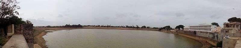
Bhuj has an average elevation of 110 metres (360 feet). On the eastern side of the town is a hill known as Bhujia Hill, on which there is a Bhujia Fort, that separates Bhuj city and Madhapar town. It has one major lake Hamirsar and several small lakes.
Climate
| Climate data for Bhuj (1981–2010) | |||||||||||||
|---|---|---|---|---|---|---|---|---|---|---|---|---|---|
| Month | Jan | Feb | Mar | Apr | May | Jun | Jul | Aug | Sep | Oct | Nov | Dec | Year |
| Record high °C (°F) | 37.0 (98.6) |
38.9 (102) |
43.9 (111) |
45.6 (114.1) |
47.8 (118) |
47.0 (116.6) |
41.3 (106.3) |
41.2 (106.2) |
42.8 (109) |
44.0 (111.2) |
39.7 (103.5) |
35.4 (95.7) |
47.8 (118) |
| Average high °C (°F) | 27.4 (81.3) |
30.4 (86.7) |
35.4 (95.7) |
38.9 (102) |
39.4 (102.9) |
37.6 (99.7) |
34.2 (93.6) |
32.7 (90.9) |
34.9 (94.8) |
36.9 (98.4) |
33.1 (91.6) |
28.7 (83.7) |
34.1 (93.4) |
| Average low °C (°F) | 10.0 (50) |
12.8 (55) |
18.1 (64.6) |
22.3 (72.1) |
25.5 (77.9) |
27.2 (81) |
26.4 (79.5) |
25.3 (77.5) |
24.3 (75.7) |
21.7 (71.1) |
16.0 (60.8) |
11.2 (52.2) |
20.1 (68.2) |
| Record low °C (°F) | −0.2 (31.6) |
0.3 (32.5) |
5.5 (41.9) |
12.7 (54.9) |
16.6 (61.9) |
16.1 (61) |
19.4 (66.9) |
20.0 (68) |
17.8 (64) |
11.1 (52) |
6.0 (42.8) |
0.6 (33.1) |
−0.2 (31.6) |
| Average precipitation mm (inches) | 1.3 (0.051) |
0.3 (0.012) |
1.1 (0.043) |
0.2 (0.008) |
1.5 (0.059) |
35.6 (1.402) |
130.9 (5.154) |
99.7 (3.925) |
48.6 (1.913) |
2.3 (0.091) |
1.8 (0.071) |
0.2 (0.008) |
323.3 (12.728) |
| Average rainy days | 0.2 | 0.0 | 0.2 | 0.1 | 0.3 | 1.8 | 5.0 | 3.8 | 2.2 | 0.4 | 0.2 | 0.1 | 14.3 |
| Source: India Meteorological Department (record high and low up to 2010)[5][6] | |||||||||||||
Places of interest
- The fort:The old city was surrounded by the fort-wall which had five major gates; Mahadev, Patvadi, Sirpat, Bhidval and Vaniyavad; and one small gate known as Chhathi Bari (sixth window). The fort-wall is thirty five feet high and four feet thick armed with fifty-one guns in past.[3] Much of the fort wall has either fallen down or been demolished, due to the city's development and the earthquake of 2001.
- Hamirsar Lake
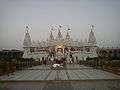
- Prag Mahal
- Aina Mahal
- Sharadbaug Palace
- Chhatardi
- Kutch Museum
- Ramkund
- Bharatiya Sanskriti Darshan Museum
- Swaminarayan temple
- Bhujia Fort and Smritivan on Bhujia Hill
- Hill Garden
- Tapkeshwari Temple
-
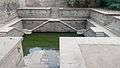
Ramkund
-
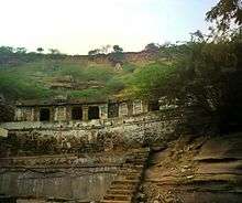
caves at Tapkeshwari Temple


Demographics
The total population of Bhuj was 299,983 in the year 2011, which consisted of 152,222 males and 147,761 females. .[1]
Culture
Bhuj is a famous destination for shopping of handicraft work like bandhni (tie-dye) and leatherwork. Artists of nearby villages bring their artwork for sale in Bhuj haat which is situated near jubilee ground. Bhuj is famous for the jolly nature of its citizens, who usually go to the surroundings of Hamirsar lake to relax.
Bhuj is also famous for its food, especially pakvans, dabelies (a local burger stuffed with mashed potato, cooked with masala curry and serious chutneys). Bhuj is famous for its Gujarati thali which is unlimited Gujarati food.
Media and communications
State-owned All India Radio has a local station in Bhuj which transmits various programs of mass interest.
Education

Alfred High School, the first high school of Kutch, established in 1870, is also an architectural heritage of the town.
Krantiguru Shyamji Krishna Verma Kachchh University is located in Bhuj. The university has 41 colleges affiliated, nineteen of which are in Bhuj. The university gives degrees in Arts, Science, Commerce, Law Education, Management, Pharmacy, Social Welfare, Medicine and Engineering.[7]
Primary and Secondary
- Alfred High School
- Archna St. Xavier's School
- Doon Public School
- Army Public School
- Indirabai Girls High school
- Matruchhaya Kanaya Sala
- R D Varsani High School
- Sanskar School
- Seth Virji Devsi Highschool
- Shree Swaminarayan Secondary and Higher Secondary School
- Swaminarayan Kanya Vidyalaya
- White house Public School
Higher education
- Adani Institute of Medical Science
- Government Engineering College, Bhuj
- Government Polytechnic
- Lalan College
- Industrial Training Institute
- J B Thacker Commerce College
- Sanskar College
Transportation


Bhuj is connected to Ahmedabad, Mumbai, Delhi, Gandhinagar, Pune, Visakhapatnam and other major cities of India by railway trains. It has a domestic airport from which daily flights connect to Mumbai, with flights operated by Jet Airways and Air India. State Transport buses are available from the ST stand in the middle of the town to various places in Gujarat. Additionally, many private tour operators also run frequent buses to major cities in and outside Gujarat. Kandla Airport is 53 km from Bhuj. The city can be navigated by the city bus and auto rickshaw.
Trains
| Train no. | Train Name | Runs From | Destination | Departure Days | Arrival Days |
|---|---|---|---|---|---|
| 11091-11092 | Ahimsa Express | Bhuj | Pune | Wednesday | Tuesday |
| 14312-14311 via Ahmedabad & 14322-14321 via Bhildi | Ala Hazrat Express | Bhuj | Bareilly | Tuesday, Thursday & Sunday for 14312. Monday, Wednesday, Friday & Saturday for 14322 | Friday, Saturday, Monday for 14311. Tuesday, Wednesday, Thursday & Sunday for 14321 |
| 22829-22830 | Shalimar - Bhuj Weekly SF Express | Bhuj | Shalimar | Tuesday | Monday |
| 22904-22903 | Bandra Terminus Bhuj AC Superfast Express | Bhuj | Bandra | Monday, Thursday, Saturday | Thursday, Saturday, Monday |
| 12960-12959 | Bhuj Dadar Superfast Express | Bhuj | Dadar | Monday, Thursday | Wednesday, Saturday |
| 19132-19131 | Kutch Express | Bhuj | Bandra | Daily | Daily |
| 19116-19115 | Shayajinagari Express | Bhuj | Bandra | Daily | Daily |
Flight

Bhuj has well connected flights to Mumbai provided by the airlines of Jet Airways and Air India Regional.
| Airline | Departs | Arrives |
|---|---|---|
| Jet Airways | Bhuj | Mumbai |
| Air India Regional | Bhuj | Mumbai |
References
- 1 2 "Census of India". The Registrar General & Census Commissioner, India, New Delhi, Ministry of Home Affairs, Government of India. 2007-06-26. Retrieved 2015-09-03.
- ↑ Ward (1 January 1998). Gujarat–Daman–Diu: A Travel Guide. Orient Longman Limited. pp. 316–317. ISBN 978-81-250-1383-9.
- 1 2 3 4 Gazetteer of the Bombay Presidency: Cutch, Palanpur, and Mahi Kantha. Printed at the Government Central Press. 1880. pp. 215–216.
- ↑ "Quake rocks Kutch". The Hindu. 24 July 1956. Retrieved 16 December 2013.
- ↑ "Bhuj Climatological Table Period: 1981–2010". India Meteorological Department. Retrieved April 10, 2015.
- ↑ "Ever recorded Maximum and minimum temperatures up to 2010" (PDF). India Meteorological Department. Archived from the original (PDF) on May 21, 2013. Retrieved April 10, 2015.
- ↑ "ક્રાંતિગુરુ શ્યામજી કૃષ્ણ વર્મા કચ્છ યુનિવર્સિટી". Kskvku.digitaluniversity.ac. Retrieved 2012-08-05.
- This article incorporates Public Domain text from Gazetteer of the Bombay Presidency: Cutch, Palanpur, and Mahi Kantha. Printed at the Government Central Press. 1880. p. 216.
External links
- Kachchh University
- Bhuj Bole Chhe - Website maintained by the citizens of Bhuj about their city
- Official Facebook page for Bhuj
- Facebook page of Bhuj Bole Chhe - Voice of Bhuj Citizens
Taluka of Bhuj | ||
|---|---|---|
| Capital Town | Bhuj |  |
| Major cities | ||
| Villages of Bhuj taluka | ||
| Topics | Sarpanch · Taluka Head · History · Notable people · Cities and Towns · Education institutes · National parks & Sanctuaries | |
| Topics |  | |
|---|---|---|
| Regions of Gujarat |
| |
| Districts | ||
| Major cities | ||
| Ecoregions | ||
| Economy |
| |
| ||