Begusarai district
| Begusarai district बेगूसराय जिला ضلع بیگو سراےء | |
|---|---|
| District of Bihar | |
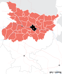 Location of Begusarai district in Bihar | |
| Country | India |
| State | Bihar |
| Administrative division | Darbhanga |
| Headquarters | Begusarai |
| Government | |
| • Lok Sabha constituencies | Begusarai |
| Area | |
| • Total | 1,918 km2 (741 sq mi) |
| Population (2011) | |
| • Total | 2,954,367 |
| • Density | 1,500/km2 (4,000/sq mi) |
| Demographics | |
| • Literacy | 66.23 per cent |
| • Sex ratio | 894 |
| Major highways | NH 31, NH 28 |
| Average annual precipitation | 1384 mm |
| Website | Official website |
Begusarai District is one of the thirty-eight districts of the Indian state of Bihar. The city of Begusarai is its administrative headquarter.
History
It was established in 1870 as of Munger District. In 1972, it was given district status.[1] Simaria village is the birthplace of famous Hindi poet Ramdhari Singh Dinkar. However most people know Munger as his birthplace as Begusarai was the part of Munger during his birth and much of his lifetime. Begusarai is the part of historic Mithila region.
Geography
Begusarai district occupies an area of 1,918 square kilometres (741 sq mi),[2] comparatively equivalent to Indonesia's Biak Island.[3] The district lies on the northern bank of river Ganges. Begusarai district is a part of Darbhanga division. It is located at latitudes 25.15N & 25.45N and longitudes 85.45E & 86.36E.
Economy
In 2006 the Indian government named Begusarai one of the country's 250 most backward districts (out of a total of 640).[4] It is one of the 36 districts in Bihar currently receiving funds from the Backward Regions Grant Fund Programme (BRGF).[4]
Transport
Barauni is the main rail head and originating place of many trains. It is connected to south Bihar by Rajendra Bridge which serves both as road and railway. NH 28 and NH 31 meet at Zero mile also known as Dinkar chouk. There are bus services for long distance places by government owned Bihar State Road Transport Corporation.
Demographics
According to the 2011 census Begusarai district has a population of 2,970,541,[5] roughly equal to the nation of Armenia[6] or the US state of Mississippi.[7] This gives it a ranking of 128th in India (out of a total of 640).[5] The district has a population density of 1,540 inhabitants per square kilometre (4,000/sq mi) .[5] Its population growth rate over the decade 2001-2011 was 26.44%.[5] Begusarai has a sex ratio of 895 females for every 1000 males,[5] and a literacy rate of 63.87%.[5]
Flora and fauna
In 1989 Begusarai district became home to the Kanwarjheel Wildlife Sanctuary, which has an area of 63 km2 (24.3 sq mi).[8]
Education
The foundation stone of Ramdhari Singh Dinkar Engineering College was laid on 22 December 2013 by Nitish Kumar,paving way for the eighth government engineering college in Bihar.[9][10]
References
- ↑ Law, Gwillim (2011-09-25). "Districts of India". Statoids. Retrieved 2011-10-11.
- ↑ Srivastava, Dayawanti et al. (ed.) (2010). "States and Union Territories: Bihar: Government". India 2010: A Reference Annual (54th ed.). New Delhi, India: Additional Director General, Publications Division, Ministry of Information and Broadcasting (India), Government of India. pp. 1118–1119. ISBN 978-81-230-1617-7.
- ↑ "Island Directory Tables: Islands by Land Area". United Nations Environment Program. 1998-02-18. Retrieved 2011-10-11.
Biak 1,904km2
- 1 2 Ministry of Panchayati Raj (September 8, 2009). "A Note on the Backward Regions Grant Fund Programme" (PDF). National Institute of Rural Development. Archived from the original (PDF) on April 5, 2012. Retrieved September 27, 2011.
- 1 2 3 4 5 6 "District Census 2011". Census2011.co.in. 2011. Retrieved 2011-09-30.
- ↑ US Directorate of Intelligence. "Country Comparison:Population". Retrieved 2011-10-01.
Armenia 2,967,975 July 2011 est.
- ↑ "2010 Resident Population Data". U. S. Census Bureau. Archived from the original on 2013-10-19. Retrieved 2011-09-30.
Mississippi 2,967,297
- ↑ Indian Ministry of Forests and Environment. "Protected areas: Bihar". Retrieved September 25, 2011.
- ↑ "CM lays foundation of engineering college". Times of India. 23 December 2013. Retrieved 23 December 2013.
- ↑ "Nitish lists special tag cry as LS poll plank". The Telegraph. 23 December 2013. Retrieved 23 December 2013.
Further reading
- Mogens Herman Hansen (2000). A Comparative Study of Thirty City-state Cultures: An Investigation. Kgl. Danske Videnskabernes Selskab. pp. 304–. ISBN 978-87-7876-177-4.
- https://books.google.com/books?id=OEZe-wAIiKIC&lpg=PA279&ots=TZDLPD6W7k&dq=naulagarh&pg=PA279
- https://books.google.com/books?id=YEWMG_8yi9oC&lpg=PA137&ots=Wwd8iWD6El&dq=naulagarh&pg=PA137
- http://wikimapia.org/13309715/hi/Naulagarh
- http://begusaraiheritage.com/history.html
- http://bihardistricts.nic.in/begusarai/districtprofile
- Begusarai Information Portal
 |
Samastipur district | Khagaria district | | |
| Patna district | |
|||
| ||||
| | ||||
| Lakhisarai district | Munger district |
Coordinates: 25°25′00″N 86°08′00″E / 25.4167°N 86.1333°E