Bundesautobahn 10
| |
|---|---|
| Bundesautobahn 10 | |
|
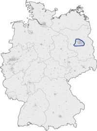
Map of Berlin (A 10 highlighted) | |
| Route information | |
| Length: | 196 km (122 mi) |
| Location | |
| States: | Berlin, Brandenburg |
| Highway system | |
| |

Bundesautobahn 10 (translates from German as Federal Motorway 10, short form Autobahn 10, abbreviated as BAB 10 or A 10) runs in Brandenburg as an orbital motorway around the German capital Berlin, colloquially called Berliner Ring. It should not be confused with the Berliner Stadtring (Bundesautobahn 100) around Berlin's inner city.
With a total length of 196 km (122 mi), the BAB 10 is the longest orbital in Europe, being 8 km (5.0 mi) longer than the London M25 motorway.
Course
The highway route markers run clockwise from the interchange at Schwanebeck (the former Prenzlau branch-off), where the Bundesautobahn 11 runs to Szczecin, Poland via the Pomellen/Kołbaskowo border crossing and the Polish A6 autostrada. From here the beltway leads southwards to the Spreeau interchange with the Bundesautobahn 12 to Frankfurt (Oder) and the Polish A2 autostrada. At the Schönefeld four-way interchange, the Bundesautobahn 13 leads to Dresden and the Bundesautobahn 113 to the Berliner Stadtring and the Berlin city centre via Berlin Brandenburg Airport.
The Berliner Ring then runs westwards to Nuthetal, where the Bundesautobahn 115 (including the former AVUS race track) also links to the Stadtring at the Funkturm Berlin. Next the Bundesautobahn 9 leads to Munich (at the Potsdam interchange) and the Bundesautobahn 2 to the Ruhr area (at Werder). From here the beltway runs northwards to the Dreieck Havelland interchange with the Bundesautobahn 24 to Hamburg, and finally turns eastwards to the Oranienburg and Pankow interchanges with the Bundesautobahn 111 and Bundesautobahn 114 motorways both leading to the Berliner Stadtring. It again reaches Schwanebeck at km 196.
History
The first sections near Werder, Schwanebeck and Spreeau were built from 1936 until the outbreak of World War II in 1939 as part of the Reichsautobahn program. Construction works were not resumed until 1972, when the East German authorities had the orbital completed until 1979, then also to bypass West Berlin on the way from the capital East Berlin to Potsdam and the motorways leading to Magdeburg and Leipzig.
Exit list
| (1) | Kreuz Barnim 3-way interchange | |
| (2) | Berlin-Hohenschönhausen | |
| (3) | Berlin-Marzahn | |
| Services Seeberg | ||
| (4) | Berlin-Hellersdorf | |
| (5) | Rüdersdorf | |
| Mühlenfließbrücke 742 m | ||
| Kalkgrabenbrücke 237 m | ||
| (6) | Erkner | |
| Löcknitzbrücke 100 m | ||
| (7) | Freienbrink | |
| Spreebrücke 200 m | ||
| (8) | Spreeau 3-way interchange | |
| (9) | Niederlehme | |
| Dahmebrücke 122 m | ||
| Wildauer Brücke 145 m | ||
| (10) | Königs Wusterhausen | |
| (11) | Schönefelder Kreuz | |
| Services Am Fichtenplan | ||
| (12) | Rangsdorf | |
| (13) | Genshagen | |
| (14) | Ludwigsfelde-Ost | |
| Ludwigsfelder Brücke 330 m | ||
| (15) | Ludwigsfelde-West | |
| Nuthebrücke 50 m | ||
| (16) | Nuthetal 3-way interchange | |
| (17) | Michendorf | |
| Services Michendorf | ||
| (18) | Ferch | |
| (19) | Potsdam 3-way interchange | |
| Grünbrücke (planned) | ||
| (20) | Glindow | |
| (21) | Dreieck Werder 3-way interchange | |
| (22) | Groß Kreutz | |
| Plessower-See-Brücke 50 m | ||
| (23) | Phöben | |
| Havelbrücke 704 m | ||
| (24) | Leest | |
| Sacrow-Paretzer-Kanal-Brücke 100 m | ||
| (25) | Potsdam-Nord | |
| Rest area Havelseen (under construction) | ||
| (26) | Berlin-Spandau | |
| (27) | Brieselang | |
| Havelbrücke 150 m | ||
| (28) | Falkensee | |
| Tankstelle Wolfslake | ||
| (29) | Dreieck Havelland 3-way interchange | |
| (30) | Oberkrämer | |
| (31) | Oranienburg 4-way interchange | |
| Oder-Havel-Kanal-Brücke 75 m | ||
| (33) | Birkenwerder | |
| parking area | ||
| Rest area Birkenwerder (under construction) | ||
| (34) | Mühlenbeck | |
| Schönwalde parking area | ||
| (35) | Berlin-Pankow 3-way interchange | |
| |
Berlin-Buchholz (planned) | |
| |
Berlin-Karow (planned) |
See also
- List of motorways in Germany
- Périphérique (Paris)
- M25 motorway (London)
- Capital Beltway (Washington, DC)
- MKAD (Moscow)
- A10 motorway (Netherlands) (Amsterdam)