Bergama
| Bergama | |
|---|---|
| District | |
|
City of Bergama | |
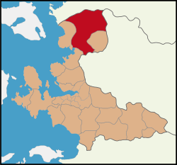 Location of Bergama within İzmir Province. | |
 Bergama Location of Bergama within İzmir Province. | |
| Coordinates: 39°07′N 27°11′E / 39.117°N 27.183°ECoordinates: 39°07′N 27°11′E / 39.117°N 27.183°E | |
| Country |
|
| Region | Aegean |
| Province | İzmir |
| Municipalities | 2 |
| Government | |
| • Mayor | Mehmet Gönenç (CHP) |
| • Prefect | Uğur KOLSUZ |
| Area[1] | |
| • District | 1,722.44 km2 (665.04 sq mi) |
| Elevation | 68 m (223 ft) |
| Population (2012)[2] | |
| • Urban | 61,406 |
| • District | 101,004 |
| • District density | 59/km2 (150/sq mi) |
| Time zone | EET (UTC+3) |
| • Summer (DST) | EEST (UTC+3) |
| Area code(s) | (+90) 232 |
| Licence plate | 35 |
| Website |
Bergama Municipality Prefecture of Bergama |
Bergama is a populous district, as well as the center city of the same district, in İzmir Province in western Turkey. By excluding İzmir's metropolitan area, it is one of the prominent districts of the province in terms of population and is largely urbanized at the rate of 53,6 per cent. Bergama center is situated at a distance of 118 km (73 mi) to the north from the point of departure of the traditional center of İzmir (Konak Square in Konak, İzmir) and lies at a distance of 27 km (17 mi) inland from the nearest seacoast at the town of Dikili to its west. Bergama district area neighbors the areas of three districts of Balıkesir Province to its north, namely Ayvalık, Burhaniye and İvrindi, İzmir Province district of Kınık and Manisa Province district of Soma, Manisa to its east, while to the south it is bordered by the central provincial of Manisa and two other İzmir Province districts along the coast that are Aliağa and Dikili from its south towards its west. The district area's physical features are determined by the alluvial plain of Bakırçay River.
Name
The name Bergama, as well as its ancient predecessor Pergamon, are thought to be connected with the even more ancient Luwian language adjective "parrai" (Hittite language equivalent; "parku"), meaning "high" in the same vein as being the etymological root of a number of other ancient cities across Anatolia. The ancient and modern Greek language form of the name is Greek: Πέργαμος. In Turkish language, it has been adapted to Bergama. The name of Pergamos derives from Perga (as keramos from kera=earth, clay), although a Turkish author Özhan Öztürk claims that Bergama means "high settlement/base" in Hittite language (reference needed), while Argoma (modern Suluova) in Amasya means "border settlement" at the Hittite-Kaskian border.[3]
General features
Currently, known for its cotton, gold, and fine carpets, the city was the ancient Greek and Roman cultural center of Pergamon; its wealth of ancient ruins continues to attract considerable tourist interest today, although its famous Temple has been moved to the Pergamon Museum, in Berlin, Germany.
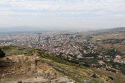
Located on a promontory north of the Bakırçay river, 26 kilometres (16 miles) inland from the Aegean Sea, Bergama has a population of about 102,000. The ruins of the ancient city of Pergamon lie to the north and west of the modern city; Roman Pergamon is believed to have sustained a population of approximately 150,000 at its height in the 1st century AD..
Among Bergama's notable ruins are the Sanctuary of Asclepius (or Asclepeion), a temple dedicated to an ancient Greek god of healing, a Greek Theater, and the Red Basilica complex ("Kızıl Avlu" in Turkish) that straddles the Selinus River, a 2nd-century AD construction likely built by Hadrian. The town also features an archaeological museum.
History
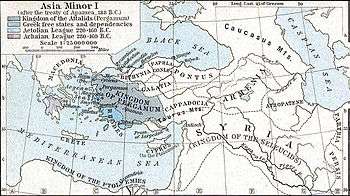
Pergamon was a small settlement during the Archaic Period. Lysimachos, one of the generals of Alexander the Great and who had become the sovereign of Anatolia after 301 BC, delivered the war expenditures, at the amount of 9000 talents (1 talent is believed to be US$7,500 approx.), to Philetarios who was the commander of Pergamon, and the kingdom founded by Philetarios by using this sum of money following Lysimachos's death, flourished and became the most eminent center of culture of the Hellenistic period for 150 years. Eumenes I, Attalos I and Eumenes II were enthroned successively after Philetarios. Eumenes II took acropolis of Athens as an example and had the acropolis of Pergamon adorned with works of art which reflected fine taste, and Pergamon became one of the most graceful cities of the world. Attalos III who succeeded Attalos II, handed over his land to the Romans when he died in 133 BC.
In the Acropolis, the remains that you see on the left hand side while going in, are the monumental tombs or heroons built for the kings of Pergamon during the Hellenistic period. Shops are situated at their side. When you enter the Acropolis, the remains seen at your left side, are the foundations of Propylon (monumental gates) which were constructed by Eumenes II. When you pass to the square surrounded with three stoas of the Doric order you will notice the ruins of the temple of Athena, built during the time of Eumenes II in the 3rd century BC. It's just above the theater. The famous Library of Pergamon which contained 200,000 books, was situated north of the square. Antonius gave all the books of the library to Cleopatra as a wedding gift. The remains near the library, are some houses from the Hellenistic period. If you go up the stairs, you will see the remains of the palaces of Eumenes II and Attalos II. Inside the Acropolis there are houses, military barracks and military warehouses called "Arsenals". The building that has been restored at present, is the Temple of Trajan. Trajan started it but after his death Emperor Hadrian (117-138) finished the temple in Corinthian order and it was placed upon a terrace with dimensions of 68 m × 58 m (223.10 ft × 190.29 ft). Attempts have been continuing by the German archaeologists since 1976 to erect this temple which has 6 x 9 columns and a peripteros plan (one row of columns around the temple). It is completely marble.
The Theater of Pergamon, one of the steepest theaters in the world, has a capacity of 10,000 people and was constructed in the 3rd century BC. The theater underwent changes during the Roman period under the reign of Caracalla. There is a 246.5 m (808.73 ft) long and approximately 16 m (52.49 ft) wide stoa (portico) in front of the theater. The road in front of the theater leads to the Temple of Dionysos (known in Rome as Baccus, god of wine). The temple was constructed in the 2nd century BC and reconstructed in marble during Caracalla's period (211-217 AD). Its dimensions are 11.80 m × 20.22 m (38.71 ft × 66.34 ft). The temple, which arouses interest because of the staircase in front with a height of 4.5 m (14.76 ft) and 25 steps, has an exquisite appearance.
The famous Altar of Zeus in Pergamon is on the south of the theater. Eumenes II (197-159 BC) constructed it as a memorial of the victory against the Galatians. This Altar has the shape of a horseshoe and its dimensions are 36.44 m × 34.20 m (119.55 ft × 112.20 ft). It is composed of four parts and the high relieves on it describe the war between the giants and the gods. The Altar which was taken away from Pergamon in 1871 and carried to Germany by the German engineer Carl Humann, is exhibited at the Museum of Pergamum in Berlin, in a manner conforming to its original. Today the Turkish government is trying to get it back from Germany bringing the issue to the International Court of Justice in The Hague. On the south of the Altar, the Agora (market place) belonging to the 2nd century BC, is situated. In the middle of the Agora there is a small altar. Downwards in the Acropolis, the central city is placed. Inside Pergamon, there is the Temple of Serapis, built for the Egyptian Gods in the 2nd century AD. and called the Red Courtyard by locals. This is a basilica shaped building constructed under the reign of Hadrian, then, in the 4th century, it was converted into a church dedicated to St. John and became one of the Seven Churches of Christianity.
The museum is in Bergama and Asklepion (the ancient medical complex, hospital) is out of the city. It is believed that Asklepion, built in the name of Aesculapius, the god of Health and Medicine, has existed since the 4th century BC. It contains premises such as a small theater with a capacity of 3,500 people, rooms where the patients were cured by the sound of water and music, the temple of Asklepion and the library. Here, the dreams of the patients were analyzed by their doctors (priests) 2000 years before Sigmund Freud did. One of the important personalities associated with the Asklepion was Galen (Galenus) from the 2nd century AD. It was under Eastern Roman rule except Sassanid invasion in 620s, Umayyad invasion in 715 and Sultanate of Rum rule between 1074 and 1097. It was conquered by Karasids in 1302. It was part of Ottoman Empire in 1337. During Ottoman rule, it was part of the Sanjak of Karesi between 1337 and 1868, in Saruhan one (Its centre was Manisa) between 1868 and 1877 and finally in İzmir one. During Turkish War of Independence, it was occupied by Greece in June 19, 1919, but came under Turkish control in September 14, 1922.
Sights of interest within Bergama city
- Selçuk Minaret built in the 14th century
- Çukurhan caravanserai built in the 14th century
- Taşhan caravanserai built in 1432
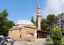
- Great Mosque of Bergama built in 1399
- Şadırvanlı Mosque built in 1550
- Zeus Altar (Now in Berlin Museum)
- Acropolis - accessible by the Bergama Acropolis Gondola from the base station north east of the town[4]
- Asklepion
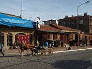
Bergama is also known for its historic quarter, where old Ottoman houses in the traditional style are found.
Allianoi
Allianoi is an ancient spa settlement, with remains dating predominantly from the Roman Empire period (2nd century AD) located near the city of Bergama (ancient Pergamon) in Turkey's İzmir Province. The site is at a distance of 18 kilometres (11 miles) to the northeast of Bergama, on the road to the neighboring town of İvrindi.
One particularity of Allianoi is its being a very recent historical discovery. It was mentioned only once in the 2nd century by the orator and medicinal writer Aelius Aristides in his "Hieroi Logoi" (Sacred Tales) (III.1), one of the key sources for the knowledge on the science of healing as it was understood at that time. No other writer of antiquity nor any epigraphic finding known had referred to Allianoi.
Kozak Plateau
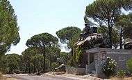
Kozak Plateau (Kozak Yaylası) is a high plain at an altitude varying between 500 and 1000 meters and starting at a distance of 20 km (12 mi) from Bergama center in the northern direction. The plain is a favorite regional excursion area, famed for its hand-made textile products and pine forests whose pine nut is also extensively exported.
Ovacık gold mine
Recently, Bergama also made headlines in the context of controversies based on environmental concerns over the gold mine in Ovacık village.[5][6]
Bergama Carpets
Bergama is also renowned for its high quality carpets. There are approximately eighty villages that still weave Bergama carpets. The history of carpet weaving in Bergama dates back to the 11th century - when Turkish migration started to the area. Bergama carpets have almost always been woven with wool - an attestation to the pastoral life style of the Yörük clans populating the area at the time.
Although the history of carpet weaving in Bergama dates back to the 11th century, most surviving carpets do not age more than 200 years - mainly due to their wool content. The oldest surviving Bergama carpets can be found in mosques in and around Bergama, as well as the archaeological museum in Bergama.
Bergama Festival
Between June 18–24, Bergama celebrates its annual festival "Bergama Kermesi", which is already running into its seventy-second anniversary. Bergama Kermesi is a major local event, generally celebrated with the attendance of Turkish celebrities, singers, players, poets, and writers.
International Relations
Twin towns - sister cities
Bergama is twinned with:
See also
References
- ↑ "Area of regions (including lakes), km²". Regional Statistics Database. Turkish Statistical Institute. 2002. Retrieved 2013-03-05.
- ↑ "Population of province/district centers and towns/villages by districts - 2012". Address Based Population Registration System (ABPRS) Database. Turkish Statistical Institute. Retrieved 2013-02-27.
- ↑ Hittite Parku "high" + huma(ti) “base/settlement" and Arguma erha “border" + huma(ti) “base/settlement" Özhan Öztürk. P Pontus: Antik Çağ’dan Günümüze Karadeniz’in Etnik ve Siyasi Tarihi. Genesis Yayınları. Ankara, 2011 pp. 438-39
- ↑ "GD8 Bergama - References - Company - LEITNER ropeways". www.leitner-ropeways.com. Retrieved 2016-09-14.
- ↑ Managing cyanide: health, safety and risk management practices at Turkey's Ovacik gold–silver mine, Journal of Cleaner Production vol. 14, 8, 2
- ↑ "European Court of Human Rights judgment on the Bergama Mine in Turkey" Mines and Communities, published 01-05-2001, access on 31-03-2012
- ↑ "Piatra Neamţ - Twin Towns". © 2007-2008 Piatra-Neamt.net. Retrieved 2009-09-27. External link in
|publisher=(help)
External links
| Wikimedia Commons has media related to Bergama. |
| Wikivoyage has a travel guide for Bergama. |
