Benson, Minnesota
| Benson, Minnesota | |
|---|---|
| City | |
|
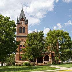
The Swift County Courthouse is one of several buildings in Benson on the National Register of Historic Places. | |
 Location of Benson within Swift County, Minnesota | |
| Coordinates: 45°18′55″N 95°36′14″W / 45.31528°N 95.60389°W | |
| Country | United States |
| State | Minnesota |
| County | Swift |
| Area[1] | |
| • Total | 3.02 sq mi (7.82 km2) |
| • Land | 3.00 sq mi (7.77 km2) |
| • Water | 0.02 sq mi (0.05 km2) |
| Elevation | 1,047 ft (319 m) |
| Population (2010)[2] | |
| • Total | 3,240 |
| • Estimate (2012[3]) | 3,164 |
| • Density | 1,080.0/sq mi (417.0/km2) |
| Time zone | Central (CST) (UTC-6) |
| • Summer (DST) | CDT (UTC-5) |
| ZIP code | 56215 |
| Area code(s) | 320 |
| FIPS code | 27-05212[4] |
| GNIS feature ID | 0639933[5] |
| Website | www.bensonmn.org |
Benson is a city in Swift County, Minnesota, United States, which is located along the Chippewa River. The population was 3,240 at the 2010 census.[6] It is the county seat.[7]
History
Benson was platted in 1870 when the railroad was extended to that point.[8] The city was named for Ben. H. Benson, a Norwegian settler.[8] A post office has been in operation at Benson since 1870.[9] Benson was incorporated as a city in 1908.[8]
Geography
According to the United States Census Bureau, the city has a total area of 3.02 square miles (7.82 km2); 3.00 square miles (7.77 km2) is land and 0.02 square miles (0.05 km2) is water.[1]
U.S. Highway 12 and Minnesota State Highways 9 and 29 are three of the main routes in the city.
Demographics
| Historical population | |||
|---|---|---|---|
| Census | Pop. | %± | |
| 1880 | 456 | — | |
| 1890 | 877 | 92.3% | |
| 1900 | 1,525 | 73.9% | |
| 1910 | 1,677 | 10.0% | |
| 1920 | 2,111 | 25.9% | |
| 1930 | 2,095 | −0.8% | |
| 1940 | 2,729 | 30.3% | |
| 1950 | 3,398 | 24.5% | |
| 1960 | 3,678 | 8.2% | |
| 1970 | 3,484 | −5.3% | |
| 1980 | 3,656 | 4.9% | |
| 1990 | 3,235 | −11.5% | |
| 2000 | 3,376 | 4.4% | |
| 2010 | 3,240 | −4.0% | |
| Est. 2015 | 3,075 | [10] | −5.1% |
| U.S. Decennial Census | |||
2010 census
As of the census[2] of 2010, there were 3,240 people, 1,469 households, and 828 families residing in the city. The population density was 1,080.0 inhabitants per square mile (417.0/km2). There were 1,602 housing units at an average density of 534.0 per square mile (206.2/km2). The racial makeup of the city was 97.2% White, 0.5% African American, 0.4% Native American, 0.2% Asian, 0.1% Pacific Islander, 0.6% from other races, and 1.0% from two or more races. Hispanic or Latino of any race were 2.6% of the population.
There were 1,469 households of which 24.8% had children under the age of 18 living with them, 44.7% were married couples living together, 8.0% had a female householder with no husband present, 3.7% had a male householder with no wife present, and 43.6% were non-families. 38.7% of all households were made up of individuals and 21.2% had someone living alone who was 65 years of age or older. The average household size was 2.14 and the average family size was 2.85.
The median age in the city was 43.6 years. 21.9% of residents were under the age of 18; 7% were between the ages of 18 and 24; 22.5% were from 25 to 44; 25.9% were from 45 to 64; and 22.5% were 65 years of age or older. The gender makeup of the city was 47.8% male and 52.2% female.
2000 census
As of the census[4] of 2000, there were 3,376 people, 1,451 households, and 880 families residing in the city. The population density was 1,360.5 people per square mile (525.6/km²). There were 1,566 housing units at an average density of 631.1 per square mile (243.8/km²). The racial makeup of the city was 98.07% White, 0.24% African American, 0.24% Native American, 0.24% Asian, 0.06% Pacific Islander, 0.50% from other races, and 0.65% from two or more races. Hispanic or Latino of any race were 1.18% of the population.
There were 1,451 households out of which 27.8% had children under the age of 18 living with them, 51.5% were married couples living together, 6.6% had a female householder with no husband present, and 39.3% were non-families. 36.2% of all households were made up of individuals and 23.6% had someone living alone who was 65 years of age or older. The average household size was 2.24 and the average family size was 2.94.
In the city the population was spread out with 23.5% under the age of 18, 7.7% from 18 to 24, 22.9% from 25 to 44, 21.6% from 45 to 64, and 24.4% who were 65 years of age or older. The median age was 42 years. For every 100 females there were 86.2 males. For every 100 females age 18 and over, there were 82.9 males.
The median income for a household in the city was $32,234, and the median income for a family was $44,638. Males had a median income of $31,280 versus $23,444 for females. The per capita income for the city was $17,269. About 3.2% of families and 8.0% of the population were below the poverty line, including 4.0% of those under age 18 and 14.7% of those age 65 or over.
Climate
| Climate data for Benson, Minnesota | |||||||||||||
|---|---|---|---|---|---|---|---|---|---|---|---|---|---|
| Month | Jan | Feb | Mar | Apr | May | Jun | Jul | Aug | Sep | Oct | Nov | Dec | Year |
| Average high °F (°C) | 19.8 (−6.8) |
26.1 (−3.3) |
38.6 (3.7) |
56.6 (13.7) |
70.6 (21.4) |
79.6 (26.4) |
84.4 (29.1) |
81.6 (27.6) |
71.7 (22.1) |
59.4 (15.2) |
40.1 (4.5) |
24.2 (−4.3) |
54.4 (12.4) |
| Average low °F (°C) | 0.3 (−17.6) |
6.6 (−14.1) |
20.3 (−6.5) |
34.4 (1.3) |
46.4 (8) |
56.1 (13.4) |
61 (16) |
58.2 (14.6) |
48.4 (9.1) |
37 (3) |
22.6 (−5.2) |
7 (−14) |
33.2 (0.7) |
| Average rainfall inches (mm) | 0.9 (23) |
0.9 (23) |
1.7 (43) |
2.4 (61) |
3 (80) |
4.4 (112) |
3.5 (89) |
3.4 (86) |
2.8 (71) |
2.4 (61) |
1.3 (33) |
0.8 (20) |
27.5 (699) |
| Average snowfall inches (cm) | 9.7 (24.6) |
8.4 (21.3) |
9.3 (23.6) |
1.9 (4.8) |
0 (0) |
0 (0) |
0 (0) |
0 (0) |
0 (0) |
0.5 (1.3) |
5.6 (14.2) |
7.6 (19.3) |
42.7 (108.5) |
| Source: Weatherbase[11] | |||||||||||||
Alternative energy
Benson is the home of the United States' first biomass powerplant, Fibrominn which opened in 2007.
Benson is also home to the Chippewa Valley Ethanol Company (CVEC), which produces E85.
Notable people
- Darwin Hall (1844–1919), American politician who served in the U.S. House of Representatives from 1889 to 1891. Hall also served in the Minnesota House of Representatives and the Minnesota Senate.
- Sandra Peterson, Minnesota state legislator.
Bands
- Tiny Moving Parts, emo/math rock band
References
- 1 2 "US Gazetteer files 2010". United States Census Bureau. Archived from the original on 2012-07-14. Retrieved 2012-11-13.
- 1 2 "American FactFinder". United States Census Bureau. Retrieved 2012-11-13.
- ↑ "Population Estimates". United States Census Bureau. Archived from the original on 2013-06-17. Retrieved 2013-05-28.
- 1 2 "American FactFinder". United States Census Bureau. Archived from the original on 2013-09-11. Retrieved 2008-01-31.
- ↑ "US Board on Geographic Names". United States Geological Survey. 2007-10-25. Retrieved 2008-01-31.
- ↑ "2010 Census Redistricting Data (Public Law 94-171) Summary File". American FactFinder. U.S. Census Bureau, 2010 Census. Archived from the original on 21 July 2011. Retrieved 23 April 2011.
- ↑ "Find a County". National Association of Counties. Archived from the original on 2011-05-31. Retrieved 2011-06-07.
- 1 2 3 Upham, Warren (1920). Minnesota Geographic Names: Their Origin and Historic Significance. Minnesota Historical Society. p. 540.
- ↑ "Swift County". Jim Forte Postal History. Retrieved 9 August 2015.
- ↑ "Annual Estimates of the Resident Population for Incorporated Places: April 1, 2010 to July 1, 2015". Retrieved July 2, 2016.
- ↑ "Weatherbase: Historical weather for Benson, Minnesota USA". Retrieved January 9, 2009.
External links
Municipalities and communities of Swift County, Minnesota, United States | ||
|---|---|---|
| Cities | 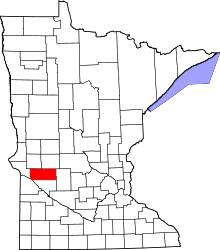 | |
| Townships | ||
| Unincorporated community | ||
Coordinates: 45°18′54″N 95°36′00″W / 45.31500°N 95.60000°W