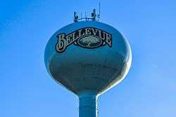
Bellevue, Wisconsin
| Bellevue, Wisconsin | |
|---|---|
| Village | |
 | |
 Location in Brown County and the state of Wisconsin. | |
| Coordinates: 44°27′50″N 87°57′54″W / 44.46389°N 87.96500°WCoordinates: 44°27′50″N 87°57′54″W / 44.46389°N 87.96500°W | |
| Country | United States |
| State | Wisconsin |
| County | Brown |
| Area[1] | |
| • Total | 14.39 sq mi (37.27 km2) |
| • Land | 14.34 sq mi (37.14 km2) |
| • Water | 0.05 sq mi (0.13 km2) |
| Elevation[2] | 669 ft (204 m) |
| Population (2010)[3] | |
| • Total | 14,570 |
| • Estimate (2012[4]) | 14,760 |
| • Density | 1,016.0/sq mi (392.3/km2) |
| Time zone | Central (CST) (UTC-6) |
| • Summer (DST) | CDT (UTC-5) |
| Area code(s) | 920 |
| FIPS code | 55-06350[5] |
| GNIS feature ID | 1582787[2] |
| Website |
villageofbellevue |
Bellevue is a village in Brown County, Wisconsin, United States. It was a town until incorporating as a village on February 14, 2003. The population was 14,570 at the 2010 census.
Bellevue is part of the Green Bay Metropolitan Statistical Area.
History
Bellevue was named for the French words meaning "beautiful view".[6]
Geography
Bellevue is located at 44°27′49″N 87°57′54″W / 44.46361°N 87.96500°W (44.463878, -87.965106).[7]
According to the United States Census Bureau, the village has a total area of 14.39 square miles (37.27 km2), of which, 14.34 square miles (37.14 km2) of it is land and 0.05 square miles (0.13 km2) is water.[1]
Demographics
| Historical population | |||
|---|---|---|---|
| Census | Pop. | %± | |
| 2010 | 14,570 | — | |
| Est. 2015 | 15,317 | [8] | 5.1% |
2010 census
As of the census[3] of 2010, there were 14,570 people, 5,876 households, and 3,883 families residing in the village. The population density was 1,016.0 inhabitants per square mile (392.3/km2). There were 6,314 housing units at an average density of 440.3 per square mile (170.0/km2). The racial makeup of the village was 87.5% White, 1.0% African American, 0.9% Native American, 3.9% Asian, 4.9% from other races, and 1.9% from two or more races. Hispanic or Latino of any race were 9.3% of the population.
There were 5,876 households of which 33.7% had children under the age of 18 living with them, 53.5% were married couples living together, 9.0% had a female householder with no husband present, 3.7% had a male householder with no wife present, and 33.9% were non-families. 26.5% of all households were made up of individuals and 9.4% had someone living alone who was 65 years of age or older. The average household size was 2.48 and the average family size was 3.04.
The median age in the village was 36.3 years. 25.8% of residents were under the age of 18; 8.3% were between the ages of 18 and 24; 27.5% were from 25 to 44; 27.4% were from 45 to 64; and 10.9% were 65 years of age or older. The gender makeup of the village was 48.7% male and 51.3% female.
2000 census

As of the census[5] of 2000, there were 11,828 people, 4,624 households, and 3,111 families residing in the village. The population density was 829.0 people per square mile (320.0/km²). There were 4,759 housing units at an average density of 333.5 per square mile (128.8/km²). The racial makeup of the village was 95.40% White, 0.51% African American, 0.84% Native American, 1.35% Asian, 0.02% Pacific Islander, 1.10% from other races, and 0.79% from two or more races. Hispanic or Latino of any race were 2.62% of the population.
There were 4,624 households out of which 36.7% had children under the age of 18 living with them, 56.2% were married couples living together, 7.6% had a female householder with no husband present, and 32.7% were non-families. 23.1% of all households were made up of individuals and 4.3% had someone living alone who was 65 years of age or older. The average household size was 2.54 and the average family size was 3.08.
In the village the population was spread out with 26.9% under the age of 18, 9.6% from 18 to 24, 36.1% from 25 to 44, 20.2% from 45 to 64, and 7.2% who were 65 years of age or older. The median age was 33 years. For every 100 females there were 98.1 males. For every 100 females age 18 and over, there were 97.1 males.
The median income for a household in the village was $53,672, and the median income for a family was $62,299. Males had a median income of $40,194 versus $26,189 for females. The per capita income for the village was $24,283. About 3.3% of families and 4.2% of the population were below the poverty line, including 4.3% of those under age 18 and 9.6% of those age 65 or over.
References
- 1 2 "US Gazetteer files 2010". United States Census Bureau. Archived from the original on 2012-07-14. Retrieved 2012-11-18.
- 1 2 "US Board on Geographic Names". United States Geological Survey. 2007-10-25. Retrieved 2008-01-31.
- 1 2 "American FactFinder". United States Census Bureau. Retrieved 2012-11-18.
- ↑ "Population Estimates". United States Census Bureau. Archived from the original on 2013-06-17. Retrieved 2013-06-24.
- 1 2 "American FactFinder". United States Census Bureau. Archived from the original on 2013-09-11. Retrieved 2008-01-31.
- ↑ A History of the Origin of the Place Names. 1908. p. 43.
- ↑ "US Gazetteer files: 2010, 2000, and 1990". United States Census Bureau. 2011-02-12. Retrieved 2011-04-23.
- ↑ "Annual Estimates of the Resident Population for Incorporated Places: April 1, 2010 to July 1, 2015". Retrieved July 2, 2016.
- ↑ "Census of Population and Housing". Census.gov. Archived from the original on May 11, 2015. Retrieved June 4, 2015.
External links
| Core city |  | |
|---|---|---|
| Largest municipalities over 10,000 in 2010 | ||
| Municipalities under 10,000 in 2010 | ||
| Counties | ||
Municipalities and communities of Brown County, Wisconsin, United States | ||
|---|---|---|
| Cities | 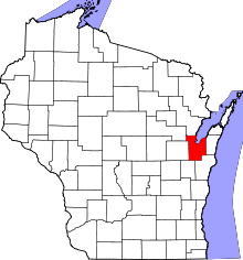 | |
| Villages | ||
| Towns | ||
| CDPs | ||
| Unincorporated communities |
| |
| Indian reservation | ||
| Ghost towns/ neighborhoods | ||
| Footnotes | ‡This populated place also has portions in an adjacent county or counties | |