Belleville, Wisconsin
| Belleville, Wisconsin | |
|---|---|
| Village | |
|
Library Park, with the old Village Hall (1894) in its center, is listed on the National Register of Historic Places | |
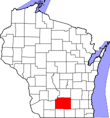
 Location in Dane County and the state of Wisconsin. | |
| Coordinates: 42°51′42″N 89°32′12″W / 42.86167°N 89.53667°WCoordinates: 42°51′42″N 89°32′12″W / 42.86167°N 89.53667°W | |
| Country | United States |
| State | Wisconsin |
| Counties | Dane, Green |
| Area[1] | |
| • Total | 1.78 sq mi (4.61 km2) |
| • Land | 1.58 sq mi (4.09 km2) |
| • Water | 0.20 sq mi (0.52 km2) |
| Elevation[2] | 873 ft (266 m) |
| Population (2010)[3] | |
| • Total | 2,385 |
| • Estimate (2012[4]) | 2,424 |
| • Density | 1,509.5/sq mi (582.8/km2) |
| Time zone | Central (CST) (UTC-6) |
| • Summer (DST) | CDT (UTC-5) |
| Area code(s) | 608 |
| FIPS code | 55-06300[5] |
| GNIS feature ID | 1561535[2] |
| Website |
bellevillewi |

Belleville is a village in Dane and Green counties in the U.S. state of Wisconsin. The population was 2,385 at the 2010 census. Of this, 1,848 were in Dane County, and 537 were in Green County.
The Dane County portion of Belleville is part of the Madison Metropolitan Statistical Area, while the Green County portion is part of the Monroe Micropolitan Statistical Area.
Geography
Belleville is located at 42°51′42″N 89°32′12″W / 42.86167°N 89.53667°W (42.861714, -89.536631).[6]
According to the United States Census Bureau, the village has a total area of 1.78 square miles (4.61 km2), of which, 1.58 square miles (4.09 km2) of it is land and 0.20 square miles (0.52 km2) is water.[1]
Demographics
| Historical population | |||
|---|---|---|---|
| Census | Pop. | %± | |
| 1860 | 164 | — | |
| 1870 | 132 | −19.5% | |
| 1890 | 319 | — | |
| 1900 | 385 | 20.7% | |
| 1910 | 422 | 9.6% | |
| 1920 | 625 | 48.1% | |
| 1930 | 564 | −9.8% | |
| 1940 | 594 | 5.3% | |
| 1950 | 735 | 23.7% | |
| 1960 | 844 | 14.8% | |
| 1970 | 1,063 | 25.9% | |
| 1980 | 1,302 | 22.5% | |
| 1990 | 1,456 | 11.8% | |
| 2000 | 1,908 | 31.0% | |
| 2010 | 2,385 | 25.0% | |
| Est. 2015 | 2,425 | [7] | 1.7% |
2010 census
As of the census[3] of 2010, there were 2,385 people, 986 households, and 658 families residing in the village. The population density was 1,509.5 inhabitants per square mile (582.8/km2). There were 1,030 housing units at an average density of 651.9 per square mile (251.7/km2). The racial makeup of the village was 96.0% White, 0.3% African American, 0.2% Native American, 0.8% Asian, 1.7% from other races, and 1.0% from two or more races. Hispanic or Latino of any race were 3.8% of the population.
There were 986 households of which 36.3% had children under the age of 18 living with them, 52.1% were married couples living together, 9.3% had a female householder with no husband present, 5.3% had a male householder with no wife present, and 33.3% were non-families. 26.9% of all households were made up of individuals and 10.2% had someone living alone who was 65 years of age or older. The average household size was 2.42 and the average family size was 2.96.
The median age in the village was 34.9 years. 26.9% of residents were under the age of 18; 6.4% were between the ages of 18 and 24; 32.4% were from 25 to 44; 24.2% were from 45 to 64; and 10.1% were 65 years of age or older. The gender makeup of the village was 49.1% male and 50.9% female.
2000 census
As of the census[5] of 2000, there were 1,908 people, 764 households, and 540 families residing in the village. The population density was 1,648.2 people per square mile (635.1/km²). There were 788 housing units at an average density of 680.7 per square mile (262.3/km²). The racial makeup of the village was 98.32% White, 0.21% African American, 0.16% Native American, 0.31% Asian, 0.31% from other races, and 0.68% from two or more races. Hispanic or Latino of any race were 0.79% of the population.
There were 764 households out of which 37.2% had children under the age of 18 living with them, 56.3% were married couples living together, 10.2% had a female householder with no husband present, and 29.2% were non-families. 23.3% of all households were made up of individuals and 12.3% had someone living alone who was 65 years of age or older. The average household size was 2.48 and the average family size was 2.96.
In the village the population was spread out with 28.1% under the age of 18, 5.8% from 18 to 24, 34.2% from 25 to 44, 19.7% from 45 to 64, and 12.2% who were 65 years of age or older. The median age was 35 years. For every 100 females there were 94.7 males. For every 100 females age 18 and over, there were 92.8 males.
The median income for a household in the village was $49,274, and the median income for a family was $55,909. Males had a median income of $33,897 versus $26,038 for females. The per capita income for the village was $21,784. About 2.3% of families and 5.2% of the population were below the poverty line, including 8.5% of those under age 18 and 10.2% of those age 65 or over.
History
At least some of the land the village now occupies was owned between 1838 and 1841 by Daniel Webster, the American statesman, who also speculated in land on the frontier.[9] In 1845, John Frederick acquired property around the Sugar River and commenced construction of a dam and sawmill, and later a grist mill. By 1850, along with John Mitchell, Frederick platted the village and named it Belleville after his hometown of Belleville, Ontario.[10]
Culture
Belleville hosted the Belleville American Music Festival (BamFest), a two-day blues festival held the second weekend in July with local, regional, national, and international acts. In August, Belleville holds its annual Community Picnic featuring activities such as live entertainment, a softball tournament, and a car show. The annual UFO day festival and parade is held the last Saturday in October. These events are sponsored by the Belleville Chamber of Commerce.
References
- 1 2 "US Gazetteer files 2010". United States Census Bureau. Archived from the original on 2012-01-24. Retrieved 2012-11-18.
- 1 2 "US Board on Geographic Names". United States Geological Survey. 2007-10-25. Retrieved 2008-01-31.
- 1 2 "American FactFinder". United States Census Bureau. Retrieved 2012-11-18.
- ↑ "Population Estimates". United States Census Bureau. Archived from the original on 2013-06-17. Retrieved 2013-06-24.
- 1 2 "American FactFinder". United States Census Bureau. Archived from the original on 2013-09-11. Retrieved 2008-01-31.
- ↑ "US Gazetteer files: 2010, 2000, and 1990". United States Census Bureau. 2011-02-12. Retrieved 2011-04-23.
- ↑ "Annual Estimates of the Resident Population for Incorporated Places: April 1, 2010 to July 1, 2015". Retrieved July 2, 2016.
- ↑ "Census of Population and Housing". Census.gov. Archived from the original on May 11, 2015. Retrieved June 4, 2015.
- ↑ Dane County Deeds, Vol. 4, Pp. 319, 324.
- ↑ A History of Belleville and Surroundings, Belleville Area Historical Society, 2001
External links
Municipalities and communities of Green County, Wisconsin, United States | ||
|---|---|---|
| Cities |  | |
| Villages | ||
| Towns | ||
| CDP | ||
| Unincorporated communities | ||
| Ghost towns | ||
| Footnotes | ‡This populated place also has portions in an adjacent county or counties | |