Belleeks
| Belleeks | |
| Irish: Béal Leice | |
 Belleeks Post Office |
|
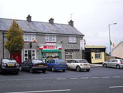
 Belleeks |
|
| Population | 375 (2011) |
|---|---|
| Irish grid reference | H987272 |
| District | Newry & Mourne |
| County | County Armagh |
| Country | Northern Ireland |
| Sovereign state | United Kingdom |
| Post town | NEWRY |
| Postcode district | BT35 |
| Dialling code | 028, +44 28 |
| EU Parliament | Northern Ireland |
| UK Parliament | Newry & Armagh |
| NI Assembly | Newry & Armagh |
|
|
Coordinates: 54°10′00″N 6°29′00″W / 54.1667°N 6.483333°W
Belleeks (from Irish: Béal Leice, meaning "ford-mouth of the flagstone")[1] is a small village and townland in south County Armagh, Northern Ireland. In the 2011 Census it had a reported population of 375.[2] It lies within the Newry and Mourne District Council area and the historic barony of Upper Fews.
Location
Belleeks lies between the villages of Camlough and Newtownhamilton, abreast the A25 between the Newtownhamilton and Newry. The nearest large town is Newry, approximately 7 miles to the east and Whitecross is the nearest settlement approximately 2 miles to the north. Belleeks lies in the townland of Belleeks Lower.
Demography
At the time of the 2001 census, returns for the Belleeks-Blackrock-Tullyah electoral area,[3] reported that:
• 26.0% were under 16 years old and 12.6% were aged 60 and above;
• The average age of a resident of the village was 30.8 years old;
• 46.3% of the population were male and 53.7% were female;
• 95.5% were from a Catholic Community Background;
• 4.5% were from a Protestant or 'Other Christian' community background;
• 13.7% had degree level or higher qualifications;
• 56.5% were economically active, 43.5% were economically inactive;
• 6.7% were unemployed, of these 42.9% were long-term unemployed;
• 68.3 stated reported their health was 'good';
• 3.22 was the average family size;
• 81.8% of households reported they had access to a private motor vehicle;
• 75.9% of homes were owner occupied and 25.5% of all homes were owed outright.
[4]
Features and economy
Saint Lawrence O'Toole's Roman Catholic Church sits in a prominent location above the village whilst a Church of Ireland church and Orange Hall lie between Belleeks and Whitecross. The village has two public houses, a small store, a part-time factory and a public common in the village centre. The village has developed from a linear settlement along the A25 as late as the 1960s with the addition of five private and local authority housing developments since the 1970s.
Most residents work away from the village. The largest local industry remaining is agriculture. Belleeks is served by the number 44 Ulsterbus service from Newry to Newtownhamilton a number of times daily as well as the number 40 service between Newry and Whitecross.
Education
There are two primary schools in or near the village; St. Brigid's Primary School and St. Laurence O'Toole's Primary School. Further schooling of residents takes place primarily at St. Paul's High School in Bessbrook, or else in Newtownhamilton or Newry.
Sport
Belleeks has a Gaelic Athletic Club, Laurence O'Toole's (Cumann Lorcáin Uí Thuathail), which competes in underage and senior men's and ladies' football as well Scor and other Armagh GAA competitions. The clubhouse is located in Shaughan in the townland of Belleeks Upper. Martin Boyle also holds a junior championship medal, which he likes to remind his friends of from time to time.
History
Early History
The area in which Belleeks is situated has been populated for many thousands of years but contains less in terms of easily discernible pre-historic remains than is widely evident in other parts of south County Armagh. What was to become the village of Belleeks was held in the estates of Hugh Boy O'Hanlon in 1641, one of the few Catholic gentry retaining substantial landholdings in County Armagh following the Plantation of Ulster, prior to the Rising of that year.
Pre-20th Century
By the early 19th century, a hamlet had developed at Belleeks along the Newtownhamilton-Newry road which branches off to Whitecross at Belleeks, Indeed, in February 1767 Sir Archibald Acheson was granted a patent to hold fairs in the village on the 3rd days of February, May, August and November every year, all bar which the February fair survived up until 1852.[5]
Census returns for the period between 1841 and 1851, during which the Famine occurred show a decrease in population of the village and surrounding area greater than one quarter of population in the ten-year period due to death and emigration.[6]
The Troubles 1969-1998
For more information on The Troubles, see The Troubles in Belleeks (Armagh), which includes a list of incidents in Belleeks during the Troubles resulting in two or more fatalities.
References
- ↑ Placenames NI Archived May 26, 2012, at the Wayback Machine.
- ↑ See Census 2011 - Headcount and Household Estimates for Settlements published by the Northern Ireland Statistics and Research Agency, available at http://www.nisra.gov.uk/census/2011/results/settlements.html
- ↑ Output Area 95VV060002
- ↑ "Census Returns for Belleeks-Blackrock-Tullyah". Northern Ireland Neighbourhood Information Service. Retrieved 2008-08-08.
- ↑ Crawford, W.H., Evolution of Towns in County Armagh, in Hughes, A.J. & Nolan, W. (2001): Armagh - History & Society Geography Publications, Dublin, p. 861
- ↑ Grant, J.,Some Aspects of the Great Famine in County Armagh, in Hughes, A.J. & Nolan, W. (2001): Armagh - History & Society Geography Publications, Dublin, p.840
External links
See also
Geography of County Armagh | ||
|---|---|---|
| Cities and towns |  | |
| Villages and townlands |
| |
| Landforms | ||
| Baronies | ||
| ||