Belfast Lower
| Belfast Lower Béal Feirste Íochtarach[1] (Irish) | |
|---|---|
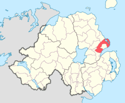 Location of Belfast Lower, County Antrim, Northern Ireland. | |
| Sovereign state | United Kingdom |
| Country | Northern Ireland |
| County | Antrim |
Belfast Lower is a barony in County Antrim, Northern Ireland.[2] To its east lies the east-Antrim coast and Belfast Lough, and it is bordered by four other baronies: Belfast Upper to the south; Carrickfergus to the east; Antrim Upper to the west; Glenarm Upper to the north.[2] The Forth and Milewater rivers both flow through Belfast Lower, with Larne harbour also situated in the barony.[1]
Roughfort
Roughfort is a medieval motte located in the barony which was used as an assembly point for the United Irishmen who were under the command of Henry Joy McCracken prior to the Battle of Antrim on 7 June 1798.[3] Thousands of Presbyterians from the surrounding area of the Six Mile Water valley rose up and fought in the battle.[3] Opposite the motte is a Liberty Tree, an American tradition where revolutionary notices where pinned to a tree.[3] Whilst Liberty Tree's in Ireland where planted in 1798, it is speculated that the one at Roughfort may have been planted the following year.[3]
List of settlements
Below is a list of settlements in Belfast Lower:[1]
Towns
- Ballyclare (split with barony of Antrim Upper)
- Newtownabbey
- Larne (Belfast Lower portion)
Villages
Population centres
- Browns Bay
- Magheramorne
- Mossley
- Straid
- Whitewell
List of civil parishes
Below is a list of civil parishes in Belfast Lower:[4][5]
- Ballylinny
- Ballymartin (split with barony of Belfast Upper)
- Ballynure
- Carnmoney
- Glynn
- Kilroot
- Inver
- Island Magee
- Raloo
- Shankill (split with barony of Belfast Upper)
- Templecorran
- Templepatrick (split with barony of Belfast Upper)
References
- 1 2 3 "Belfast Lower". Placenames Database of Ireland. Department of Community, Rural and Gaeltacht Affairs. Retrieved 5 February 2011.
- 1 2 PRONI Baronies of Northern Ireland
- 1 2 3 4 "Roughfort Motte". Touring Newtownabbey. Newtownabbey Borough Council. Retrieved 5 June 2011.
- ↑ PRONI Civil Parishes of County Antrim
- ↑ Baronies and parishes of County Antrim