Bihou

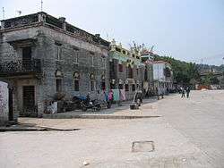


Bihou (Chinese: 庇厚), or Bei Hou or Pei Hou is a village just west of Taicheng in Taishan City in the Guangdong Province of southern China, and is located at latitude 22° 15' 09.22" N and longitude 112° 46' 01.12" E, 11 meters above sea level off the Cinnamon Stream Road (桂水路).[1] Bi Hou was founded in the 18th century by Tan Gong Chang (譚公昌), one of the many descendants of the viscounts of the feudal State of Tan (1046BC-684BC) in present-day Shandong Province.[2]
All of its inhabitants are still of one patrilineage with the clan name of Tan (譚), and have family in Taicheng and Yangjiang. Expatriate family members have settled in Australia and the United States.
Rice, fish, bananas, pawpaw and pig feed are grown around the village.
On March 3, 1941, Japanese troops attacked the village as part of the assault on the neighboring Taicheng Township.[3] Bullet holes are still visible in the fabric of the now-defunct village clan school, and through one of the neighboring palm trees.
Some years ago, the modern multi-storey Bi Hou village cultural building (庇厚村文化楼) was erected, and reported in the local media when it was opened. It is now in a dilapidated state.
References
- ↑ Bi Hou in Google Maps. This is the location on the satellite imagery and is different from that on the corresponding map.
- ↑ Tan Genealogy: Heritage and Lineage by Henry Tom, privately published, Frederick (MD) 2009.
- ↑ Taishan Timeline History
Coordinates: 22°15′9″N 112°46′1″E / 22.25250°N 112.76694°E