Bech
For the surname, see Bech (surname). For other uses, see Beč (disambiguation).
| Bech Bech | ||
|---|---|---|
| Commune | ||
 | ||
| ||
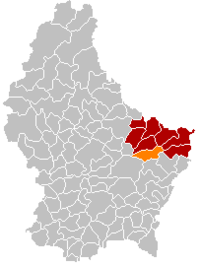 Map of Luxembourg with Bech highlighted in orange, and the canton in dark red | ||
| Coordinates: 49°45′10″N 6°21′40″E / 49.7528°N 6.3611°ECoordinates: 49°45′10″N 6°21′40″E / 49.7528°N 6.3611°E | ||
| Country |
| |
| Canton | Echternach | |
| Government | ||
| • Mayor | Camille Kohn | |
| Area | ||
| • Total | 23.31 km2 (9.00 sq mi) | |
| Area rank | 38 of 105 | |
| Highest elevation | 408 m (1,339 ft) | |
| • Rank | 43rd of 105 | |
| Lowest elevation | 261 m (856 ft) | |
| • Rank | 67th of 105 | |
| Population (2014) | ||
| • Total | 1,187 | |
| • Rank | 92nd of 105 | |
| • Density | 51/km2 (130/sq mi) | |
| • Density rank | 89th of 105 | |
| Time zone | CET (UTC+1) | |
| • Summer (DST) | CEST (UTC+2) | |
| LAU 2 | LU00006002 | |
| Website | bech.lu | |

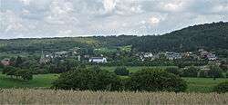
Bech is a commune and small town in eastern Luxembourg. It is part of the canton of Echternach, which is part of the district of Grevenmacher.
As of 2005, the town of Bech, which lies in the east of the commune, has a population of 368. Villages within the commune include Altrier and Rippig.
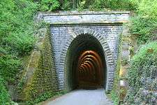
Western side of the old railway tunnel built in 1901, now converted to a bicycle route
External links
-
 Media related to Bech at Wikimedia Commons
 |
Consdorf | Echternach, Rosport | | |
| Heffingen (L) | |
Mompach | ||
| ||||
| | ||||
| Junglinster | Biwer | Manternach |
This article is issued from Wikipedia - version of the 12/1/2016. The text is available under the Creative Commons Attribution/Share Alike but additional terms may apply for the media files.