Bear Island (Norway)
| Native name: <span class="nickname" ">Bjørnøya | |
|---|---|
 Bear Island is located north of mainland Norway, in the south of the Norwegian Svalbard archipelago | |
 | |
| Geography | |
| Location | Barents Sea |
| Coordinates | 74°31′N 19°01′E / 74.517°N 19.017°ECoordinates: 74°31′N 19°01′E / 74.517°N 19.017°E |
| Archipelago | Svalbard |
| Area | 178 km2 (69 sq mi) |
| Highest elevation | 536 m (1,759 ft) |
| Highest point | Urd, Miseryfjellet |
| Administration | |
|
Norway | |
| Demographics | |
| Population | 9 (2008-08-20) |
Bear Island (Norwegian: Bjørnøya, pronounced [ˈbjøːɳøja]) is the southernmost island of the Norwegian Svalbard archipelago. The island is located in the western part of the Barents Sea, approximately halfway between Spitsbergen and the North Cape.
Bear Island was discovered by the Dutch explorers Willem Barents and Jacob van Heemskerk on June 10, 1596. It was named after a polar bear that was seen swimming nearby. The island was considered terra nullius until the Spitsbergen Treaty of 1920 placed it under Norwegian sovereignty.
Despite its remote location and barren nature, the island has seen commercial activities in past centuries, such as coal mining, fishing and whaling. However, no settlements have lasted more than a few years, and Bear Island is now uninhabited except for personnel working at the island's meteorological station Herwighamna. Along with the adjacent waters, it was declared a nature reserve in 2002.
History

Seafarers of the Viking era may have known Bear Island, but the documented history begins in 1596, when Willem Barents sighted the island on his third expedition. He named this island "Vogel Eylandt", "Bird Island" in English.[1] Steven Bennet conducted further exploration in 1603 and 1604 and noted the then rich population of walrus. Starting in the early 17th century, the island was used mainly as a base for the hunting of walrus and other seal species. Eggs of seabirds were harvested from the large bird colonies until 1971.[2]
The Muscovy Company claimed Bear Island for the English Crown in 1609, but abandoned the site when walrus-hunting declined. A Russian settlement existed in the 18th century and its remains were later used as a basis for territorial claims by Imperial Russia in 1899 and again by the Soviet Union in 1947.[3]
Bear Island has never been extensively settled. The remnants of a whaling station from the early 20th century can be seen at Kvalrossbukta ("walrus bay") in the southeast. From 1916 to 1925 coal was mined at a small settlement named Tunheim on the northeastern coast, but mining was given up as unprofitable. Due to the cold climate, the remains of the settlement, including a half-destroyed jetty and a steam locomotive, are relatively well preserved.
The strategic value of Bear Island was recognised in the late 19th century, when Imperial Russia and Imperial Germany demonstrated their interests in the Barents Sea. The German journalist and adventurer Theodor Lerner visited the island in 1898 and 1899 and claimed rights of ownership. In 1899, the German fishery association Deutsche Seefischerei-Verein (DSV) started investigations of whaling and fishery in the Barents Sea. The DSV was secretly in contact with the German naval command and considered the possibility of an occupation of Bear Island. In reaction to these advances, the Russian Navy sent out the protected cruiser Svetlana to investigate, and the Russians hoisted their flag over Bear Island on July 21, 1899. Although Lerner protested the action, no violence occurred and the matter was settled diplomatically with no definitive claims of sovereignty over Bear Island by any nation.[1]
The whole island was privately owned by the coal mining company Bjørnøen AS from 1918 to 1932, when the Norwegian state took over the shares. Bjørnøen AS now exists as a state owned company and is jointly managed with Kings Bay AS, the company that runs the operations of Ny-Ålesund on Spitsbergen.[4] A Norwegian radio station (Bjørnøya Radio, callsign: LJB[5]) was established in Herwighamna on the north coast in 1919. It was later extended to include a meteorological station.
As the shipping routes from the Atlantic Ocean to Murmansk and the ports of the White Sea pass through the Barents Sea, the waters near Bear Island were of great strategic importance in the Second World War as well as the Cold War. Although Svalbard was not occupied by Germany in the Second World War, German forces erected several weather stations there. An automated radio station was deployed on Bjørnøya in 1941. German forces attacked several arctic convoys with military supplies for the Soviet Union in the waters surrounding Bear Island. They inflicted heavy losses upon Convoy PQ-17 in June/July 1942 but were ineffective in the Battle of the Barents Sea on New Year's Eve 1942. The waters southeast of Bear Island were the scene of more naval battles in 1943. In November 1944, the Soviet Union proposed to annul the Svalbard Treaty with the intention of gaining sovereignty over Bear Island. Negotiations with Trygve Lie of the Norwegian government-in-exile had however not led to an agreement by the end of the Second World War and the Soviet proposals were never implemented.[1] The Soviet Union (and later, Russia) maintained their presence on Spitsbergen, however.
A small group of German soldiers was abandoned on Bear Island. They were supposed to establish and man a weather station there, but after losing radio contact in May 1945, they were isolated, and surrendered to some Norwegian seal hunters on 4 September. These were some of the last German soldiers to surrender in WW2.
In 2002 a nature reserve was established that covers all of the island, except 1.2 square kilometres (0.46 sq mi) around the meteorological station; the reserve also includes the adjacent waters to four nautical miles (7.4 kilometres (4.6 mi)) from the coast.[6] In 2008 the decision was made to expand the reserve to 12 nautical miles (22 km) from the coast covering 177 square kilometres (68 sq mi) on land and 2,805 square kilometres (1,083 sq mi) of sea area.[7] Today, the island's only inhabitants are the nine[8] person staff of the Norwegian meteorological and radio station at Herwighamna. The station conducts meteorological observations and provides logistic and telecommunication services, including radio watch at HF channels 2182/2168 and VHF channels 16/12. Weather forecasts are transmitted from the station twice daily, announced on HF 2182/VHF 16. It also maintains landing platforms for use by helicopters of the Norwegian Coast Guard, the Norwegian 330 Squadron, and the Governor of Svalbard. The Norwegian Polar Institute conducts annual expeditions to Bear Island, mostly concerned with ornithological research. Several other research projects, mostly pertaining to geography and climatology, are carried out less regularly. There are very few opportunities for individual travel to Bjørnøya.
Hydrography, geography and climate


Agencies of the Norwegian government have conducted Hydrographic surveys of the waters of Svalbard throughout the 20th century, namely "Norges Svalbard- og Ishavsundersøkelser" since 1928, its successor, the Norwegian Polar Institute since 1948, and the Norwegian Hydrographic Service since 1984.[9] Land surveying and mapping are the responsibilities of the Polar Institute.
Bear Island lies 235 kilometres (146 mi) south of mainland Spitsbergen and 397 kilometres (247 mi) NNW of Ingøy in mainland Norway. In the westernmost part of the Barents Sea on Spitsbergen Bank, which extends southward from Spitsbergen and Edgeøya, forming a part of the continental shelf. Water depths near the island and to the north and east do not much exceed 100 metres (328 ft), but become much greater to the south, and especially some thirty nautical miles to the west, where the continental shelf slopes into the deep water of the Norwegian Sea and Greenland Sea.
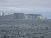
The island's outline is an irregular triangle pointing south with a greatest north-south extension of 20 kilometres (12 mi) and a greatest east-west extension of 15.5 kilometres (9.6 mi); its surface area is 178 square kilometres (69 sq mi). The southern part of Bjørnøya is mountainous, the highest top being Miseryfjellet on the southeast coast at about 536 metres (1,759 ft) above sea level. Other notable mountains are Antarcticfjellet in the southeast, and Fuglefjellet, Hambergfjellet, and Alfredfjellet in the southwest. The northern part of the island forms a lowland plain that comprises some two thirds of the surface area. The lowland is strewn with shallow freshwater lakes which cover some 19 square kilometres (7.3 sq mi) in all. Several streams flow into the sea, often as waterfalls in the steeper parts of the coast. There are no glaciers on Bear Island.
Apart from a few sandy beaches, the coast is mostly steep, with high cliffs and notable signs of erosion such as caverns and isolated rock pillars. A number of anchorages and landing points exist, as well as a small harbor at Herwighamna on the north coast. However, none of these are safe in all weather conditions and a ship mooring anywhere on Bear Island must therefore be prepared to weigh anchor at any time.
| Bear Island (1961–90) | ||||||||||||||||||||||||||||||||||||||||||||||||||||||||||||
|---|---|---|---|---|---|---|---|---|---|---|---|---|---|---|---|---|---|---|---|---|---|---|---|---|---|---|---|---|---|---|---|---|---|---|---|---|---|---|---|---|---|---|---|---|---|---|---|---|---|---|---|---|---|---|---|---|---|---|---|---|
| Climate chart (explanation) | ||||||||||||||||||||||||||||||||||||||||||||||||||||||||||||
| ||||||||||||||||||||||||||||||||||||||||||||||||||||||||||||
| ||||||||||||||||||||||||||||||||||||||||||||||||||||||||||||
A branch of the North Atlantic current carries warm water to Svalbard, creating a climate much warmer than that of other regions at similar latitude. Bear Island's climate is maritime-polar with relatively mild temperatures during the winter. January is the coldest month, with a mean temperature of −8.1°C (17.4°F) (base period 1961–1990). July and August are the warmest months, with mean temperatures of 4.4 °C (39.9 °F). Temperatures have tended to be warmer the latest decades. There is not much precipitation, with an average of 371 mm (14.6 in) per year in the northern lowland area. The weather can be quite stable during the summer months, although foggy conditions are common, occurring during 20% of all days in July. Fog develops when warm air of Atlantic origin passes over cold water.
Because Bear Island lies on a boundary between cold water of polar origin and warmer Atlantic water, water temperatures within a few dozen nautical miles of the island are quite variable, sometimes reaching 10 °C (50 °F) in summer. During the winter fast ice develops on the coast, but it is rare on the open sea around Bear Island. The Barents Sea carries pack ice to Bjørnøya every winter, sometimes as early as October, but a significant amount of ice is not common before February.
The polar night lasts from 8 November until 3 February, and the period of midnight sun from 2 May until 11 August. With just 595 hours of bright sunshine per year, Bear Island has the lowest average yearly sunshine in Europe.[10]
| Climate data for Bear Island, Norway | |||||||||||||
|---|---|---|---|---|---|---|---|---|---|---|---|---|---|
| Month | Jan | Feb | Mar | Apr | May | Jun | Jul | Aug | Sep | Oct | Nov | Dec | Year |
| Average high °C (°F) | −5.0 (23) |
−4.7 (23.5) |
−4.8 (23.4) |
−2.9 (26.8) |
0.3 (32.5) |
3.6 (38.5) |
6.6 (43.9) |
6.3 (43.3) |
4.2 (39.6) |
1.2 (34.2) |
−1.7 (28.9) |
−4.3 (24.3) |
−0.1 (31.83) |
| Daily mean °C (°F) | −7 (19) |
−7 (19) |
−7 (19) |
−4 (25) |
0 (32) |
2 (36) |
4 (39) |
4 (39) |
3 (37) |
0 (32) |
−3 (27) |
−6 (21) |
−1.7 (28.8) |
| Average low °C (°F) | −11.4 (11.5) |
−10.9 (12.4) |
−10.5 (13.1) |
−8.0 (17.6) |
−3.0 (26.6) |
0.4 (32.7) |
2.8 (37) |
3.0 (37.4) |
1.3 (34.3) |
−2.3 (27.9) |
−6.0 (21.2) |
−9.9 (14.2) |
−4.54 (23.83) |
| Average precipitation mm (inches) | 30 (1.18) |
33 (1.3) |
28 (1.1) |
21 (0.83) |
18 (0.71) |
23 (0.91) |
30 (1.18) |
36 (1.42) |
44 (1.73) |
44 (1.73) |
33 (1.3) |
31 (1.22) |
371 (14.61) |
| Average precipitation days | 9 | 9 | 9 | 6 | 5 | 6 | 7 | 7 | 10 | 10 | 9 | 9 | 96 |
| Average relative humidity (%) | 87 | 88 | 88 | 87 | 88 | 90 | 92 | 91 | 89 | 86 | 87 | 88 | 88.4 |
| Mean monthly sunshine hours | 0 | 6 | 57 | 105 | 116 | 105 | 79 | 70 | 42 | 15 | 0 | 0 | 595 |
| Source #1: http://www.theweathernetwork.com/index.php?product=statistics&pagecontent=C00009 | |||||||||||||
| Source #2: met-no/met.no/eklima | |||||||||||||
Flora and fauna
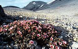
Bear Island was the site of a pioneering ecological study by Victor Summerhayes and Charles Elton in the early 1920s, which produced one of the first food web diagrams. There is little plant growth, consisting mostly of moss and some scurvy grass, but no trees.
The only indigenous land mammals are a few Arctic foxes. Despite its name, Bear Island is not a permanent residence of polar bears, although many arrive with the expanding pack ice in the winter. Occasionally, a bear will stay behind when the ice retreats in spring and remain through the summer months.[11] Moreover, the sub-population of Ursus maritimus polar bears found here is a genetically distinct set of polar bears associated with the Barents Sea region.[12] Ringed seal and bearded seal, prey of the polar bear, live in the waters near Bjørnøya, but the formerly common walrus has nowadays become a rare guest. Bear Island's freshwater lakes are home to a population of Arctic char.
Birds
The only land birds are snow buntings and rock ptarmigans, but the island is very rich in seabirds that nest on the southern cliffs. Other species visit the island during their seasonal migration between Svalbard's northern islands and mainland Europe.
Bear island has been identified as an Important Bird Area (IBA) by BirdLife International. It supports breeding populations of northern fulmars (50,000–60,000 pairs), purple sandpipers, red phalaropes (10 pairs), glaucous gulls (2000 pairs), black-legged kittiwakes (100,000 pairs), little auks (10,000–100,000 pairs), common guillemots (50,000 pairs), thick-billed guillemots (190,000 individuals) and black guillemots (1000 pairs). It also supports migratory populations of pink-footed geese (30,000 individuals), barnacle geese and long-tailed ducks.[13]
Environmental concerns
Although there are currently no industrial activities on Bjørnøya or in its immediate vicinity, pollution by toxic and radioactive substances remains a threat to the island's virtually untouched nature. Exploration in the Barents sea and the recent development of the Snøhvit gas field off the northern coast of Norway shows that the ecologically sensitive polar and subpolar sea areas of the Norwegian and Barents Sea have come into the focus of the petrol and gas industry.[14] The environmental organisation Bellona has criticised[15] the Norwegian government for licensing these activities without sufficient studies of their ecological impact. Organic toxins, specifically PCBs, have been found in high concentrations in biological samples from Bear Island, especially in Arctic char of the freshwater lake Ellasjøen.[16] The Soviet nuclear submarine Komsomolets sank on April 7, 1989 some 100 nautical miles (190 km) southwest of Bear Island.[17] Leakage of radioactive material from the reactor and nuclear warheads currently poses a problem, and severe pollution of the surrounding waters remains possible.[18]
Culture
Associations
The island has a club for nude dippers ("Bjørnøya nakenbadeforening"), with over 3,000 members.[8]
Pastime
Surfing has been documented in the movie Bjørnøya – følg drømmen [Bear Island - follow the dream].[19]
See also
- Bear Island, a novel by Alistair MacLean which is set on Bear Island
- List of islands of Norway
References
- 1 2 3 Arlov, Thor B. (2003). Svalbards historie (in Norwegian). Trondheim: Tapir Akademisk Forlag. ISBN 82-519-1851-0.
- ↑ Circumpolar Seabird Working Group (2001). "Seabird harvest regimes in the circumpolar nations" (PDF). Retrieved December 20, 2007.
- ↑ Meissner, Hans Otto (1963). Unknown Europe. trans. Florence and Isabel McHugh. London and Glasgow: Blackie & Sons. pp. 158–170.
- ↑ Norwegian Ministry of Trade and Industry (2005). "The State's Ownership Report 2004" (PDF). Retrieved February 27, 2006.
- ↑ "List of coastal radio stations" (PDF). World Meteorological Organisation. 2005. Retrieved October 9, 2006.
- ↑ Sysselmannen på Svalbard (The Governor of Svalbard) (2005). "Forvaltningsplan for Bjørnøya 2005–2010 ("Administrative plan for Bjørnøya 2005–2010")" (PDF). Archived (PDF) from the original on October 29, 2005. Retrieved November 24, 2005.
- ↑ "Enlarged nature reserve around Bear Island". Svalbardposten. The Norway Post. December 18, 2008. Retrieved December 18, 2008.
- 1 2 "Badet naken på Bjørnøya ("Swam naked on Bear island")". 2008.
- ↑ Anon. (1990). Den Norske Los – Farvannsbeskrivelse – Sailing Directions, Vol.7: "Arctic Pilot" (in Norwegian and English). Norwegian Polar Research Institute and the Norwegian Hydrographic Service. ISBN 82-90653-06-9.
- ↑ "Archived copy" (PDF). Archived (PDF) from the original on March 4, 2016. Retrieved 2015-10-13.
- ↑ Årsæther, Jan (July 27, 2004). "Isbjørnfamilie fanget på Bjørnøya ("Polar bear family trapped on Bear Island")". TV2 (Norway).
- ↑ C. Michael Hogan (2008) Polar Bear: Ursus maritimus, Globaltwitcher.com, ed. Nicklas Stromberg Archived December 24, 2008, at the Wayback Machine.
- ↑ "Bjørnøya (Bear Island)". Important Bird Areas factsheet. BirdLife International. 2013. Archived from the original on July 10, 2007. Retrieved 2013-08-22.
- ↑ Norwegian Petroleum Directorate (2005). "Barents Sea exploration celebrates 25 years". Retrieved March 1, 2006.
- ↑ Buch, Cato (2002). "Snøhvit: Reasons for Bellona's opposition". Retrieved October 18, 2005.
- ↑ Herzke, D.; Evenset A.; et al. (2004). "Polybrominated diphenylethers in biota from Bjørnøya (Bear Island)" (PDF). Archived from the original (PDF) on September 28, 2007.
- ↑ Montgomery, George (1995). "The Komsomolets Disaster". Center for the Studies of Intelligence.
- ↑ Gwynn, J.P.; Dowdall, M.; Lind, B. (2004). "The Radiological Environment of Svalbard" (PDF). Norwegian Radiation Protection Authority.
- ↑ Jakten på den unike bølgen Archived October 21, 2014, at the Wayback Machine.
External links
| Wikimedia Commons has media related to Bjørnøya. |
Publications of administrative and general interest are issued by the Governor of Svalbard . Maps, research reports, and scholarly works about Svalbard-related subjects are available from the Norwegian Polar Institute .
Books
- Bear Island: The story of an isolated arctic island – exploration, people, culture and nature by Dag Kjelldahl
General information
- Website of the meteorological station on Bear Island
- Report to the Storting (1999–2000) on Svalbard by the Norwegian Ministry of Justice and the Police – extensive report on political, administrative, economical and scientific matters relating to Svalbard
Time Zone
- TimeGenie.com – Central Europe Time zone. Standard Time difference compared to UTC/GMT is +1 hours
Maps and photos:
- Bear Island nature reserve (JPEG image) – from the Office of the Governor of Svalbard
- An interactive map of Svalbard – Bear Island included
- Detailed map northeastern part (PDF) showing the location of the meteorological station near the top
- Detailed map southern part (PDF)
- Map showing the location of Bear Island in relation to Svalbard – from the Norwegian Polar Institute
- Strategic Arctic outpost – pictorial introduction to Bear Island, from Norwegian newspaper Aftenposten, September 6, 2005
Geography, hydrography, meteorology:
- Geology of Bear Island, Norway – by Dr. Harmon D. Maher Jr., Dept of Geography and Geology, University of Nebraska at Omaha
- Svalbards geological development – By Winfried Dallmann, Norwegian Polar Institute.
- Bjørnøya and the island's meteorological station – by the Norwegian Meteorological Institute
- Monthly temperature, precipitation normals 1961–1990 – upper table: temperature (°C); lower table: precipitation (mm)
- Sea ice charts of the Bjørnøya area – updated daily on weekdays
History:
- "Meteorological operations in the Arctic 1940–1945" – by Franz Selinger; on World War II German Arctic meteorology services, incl. TAAGET station, Bjørnøya
Recent events: