Beachmont (MBTA station)
BEACHMONT | |||||||||||
|---|---|---|---|---|---|---|---|---|---|---|---|
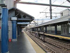 Beachmont station in 2012 | |||||||||||
| Location |
630 Winthrop Avenue at 1 Bennington Street Revere, Massachusetts | ||||||||||
| Coordinates | 42°23′51″N 70°59′32″W / 42.3975°N 70.9922°WCoordinates: 42°23′51″N 70°59′32″W / 42.3975°N 70.9922°W | ||||||||||
| Line(s) | |||||||||||
| Platforms | 2 side platforms | ||||||||||
| Tracks | 2 | ||||||||||
| Construction | |||||||||||
| Parking |
430 spaces ($5.00 fee) 6 accessible spaces | ||||||||||
| Bicycle facilities | 6 spaces | ||||||||||
| Disabled access | Yes | ||||||||||
| History | |||||||||||
| Opened | January 19, 1954 (Blue Line)[1] | ||||||||||
| Closed | January 27, 1940 (BRB&L)[2] | ||||||||||
| Rebuilt | June 24, 1995[1] | ||||||||||
| Traffic | |||||||||||
| Passengers (2013) | 3,045 (weekday average boardings)[3] | ||||||||||
| Services | |||||||||||
| |||||||||||
Beachmont is an elevated rapid transit station on the MBTA Blue Line, located above Winthrop Avenue in the Beachmont neighborhood of Revere, Massachusetts.
The station, located on an overpass above Winthrop Avenue, is one of a small number of elevated rapid transit stations remaining in the MBTA system. (The only others are Charles/MGH, Science Park, Malden Center, Wollaston and Fields Corner.) Boston once had several elevated lines, but the Atlantic Avenue Elevated, Charlestown Elevated, Washington Street Elevated, and Causeway Elevated were all torn down in favor of subway and surface-level lines.
Beachmont station is fully handicapped accessible, with elevators from the lobby to the platforms.
History
BRB&L

The narrow gauge Boston, Revere Beach and Lynn Railroad (BRB&L) opened from East Boston to Lynn on July 29, 1875; no station was originally present at Winthrop Avenue.[4] Beachmont station opened later at the Winthrop Avenue grade crossing, with a station building located southeast of the crossing. Ocean Pier station at Dolphin Avenue was open for several years in the 1880s, likely to compete with a competitor - the Eastern Railroad-backed Boston, Winthrop and Shore Railroad - which operated in 1884 and 1885.[2][5][6]
By 1928 the line was electrified, with pre-pay stations - more a rapid transit line than a conventional railroad.[7] However, due to the Great Depression, the BRB&L shut down on January 27, 1940.[2]
Rapid transit
In 1941, the Boston Elevated Railway bought the BRB&L right of way from Day Square to Revere Beach for use as a high-speed trolley line similar to the Ashmont-Mattapan High Speed Line; these plans were delayed by the onset of World War II.[8] However, the 1926 Report on Improved Transportation Facilities and 1945–47 Coolidge Commission Report recommended that the East Boston Tunnel line, which had been converted to rapid transit from streetcars in 1924, be extended to Lynn via the BBRB&L route rather than using it for a trolley line.[9][10]
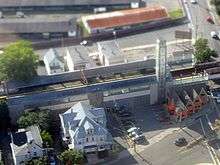
In 1947, the newly formed Metropolitan Transit Authority (M.T.A.) decided to build to Lynn as a rapid transit line, and construction began in October 1948.[8] The first part of the Revere Extension opened to Orient Heights in January 1952 and Suffolk Downs in April 1952; the second phase (cut short due to limited funds) opened to Wonderland on January 19, 1954 with intermediate stations at Beachmont and Revere Beach.[8][1] Unlike its predecessor, this Beachmont station was elevated to eliminate the grade crossing of Winthrop Avenue.
Renovations
The station was closed for approximately one year starting on June 25, 1994, as the station was rebuilt along with the Suffolk Downs, Revere Beach and Wonderland stations as part of the Blue Line Modernization Program. Blue Line service temporarily ended at Orient Heights and buses served the closed stations during the $467 million improvement project to upgrade four stations on the line.[11][1] Beachmont station was completely rebuilt at a cost of $27 million; it reopened along with the other stations on June 24, 1995.[12]
The station was closed while additional platform repair work was performed from September 8 through November 25, 2008.[1]
Bus connections
Beachmont station is served by one MBTA Bus route, with runs below the station on Winthrop Avenue:[13]
- 119 Northgate - Beachmont Station via Revere Center & Cooledge Housing
Platform layout
| Platform level | Side platform, doors will open on the right | |
| Southbound | ← Blue Line toward Bowdoin or Government Center (Suffolk Downs) | |
| Northbound | → Blue Line toward Wonderland (Revere Beach) → | |
| Ground | - | Exit/Entrance |
References
- 1 2 3 4 5 Belcher, Jonathan (27 June 2015). "Changes to Transit Service in the MBTA district 1964-2015" (PDF). NETransit. Retrieved 24 December 2015.
- 1 2 3 Karr, Ronald Dale (1995). The Rail Lines of Southern New England. Branch Line Press. pp. 268–272. ISBN 0942147022.
- ↑ "Ridership and Service Statistics" (PDF) (14 ed.). Massachusetts Bay Transportation Authority. 2014.
- ↑ Bradlee, Francis Boardman Crowninshield (1921). The Boston, Revere Beach and Lynn Narrow Gauge Railroad. Essex Institute. p. 4-5 – via Google Books.
- ↑ Stanley, Robert C. (1980). Narrow Gauge: The Story of the Boston, Revere Beach & Lynn Railroad. Boston Street Railway Association.
- ↑ "Part of the Town of Revere". Atlas of the City of Chelsea and the Towns of Revere and Winthrop. G.W. Bromley and Co. 1886 – via WardMaps.
- ↑ ""Narrow Gage" Electrified for Economy". Electric Railway Journal. 72 (23): 991–998. 8 December 1928. Retrieved 24 December 2015 – via Internet Archive.
- 1 2 3 Cheney, Frank (2003). Boston's Blue Line. Arcadia Publishing. p. 8, 83. ISBN 9780738535760.
- ↑ Central Transportation Planning Staff (15 November 1993). "The Transportation Plan for the Boston Region - Volume 2". National Transportation Library. Retrieved 3 July 2012.
- ↑ Boston Elevated Railway and Boston Department of Public Utilities (1945), Boston Rapid Transit System & Proposed Extentions 1945 - Metropolitan Transit Recess Commission Air View
- ↑ Blake, Andrew (20 March 1994). "MBTA to begin $467 million Blue Line project". Boston Globe. Retrieved 26 January 2014 – via Highbeam Research. (subscription required (help)).
- ↑ Blake, Andrew (18 June 1995). "Blue Line Stations Set to Reopen After $467M Upgrade". Boston Globe. Retrieved 4 July 2015 – via Highbeam Research. (subscription required (help)).
- ↑ "Beachmont Station Neighborhood Map" (PDF). Massachusetts Bay Transportation Authority. June 2012. Retrieved 24 December 2015.
External links
| Wikimedia Commons has media related to Beachmont (MBTA station). |
| Subway lines (List of stations) |
| |||||||||||
|---|---|---|---|---|---|---|---|---|---|---|---|---|
| Commuter Rail lines (List of stations) |
| |||||||||||
| Bus routes (List of routes) | ||||||||||||
| Other services | ||||||||||||
| Component parts of system lines | ||||||||||||
| Capital projects |
| |||||||||||
| History |
| |||||||||||
| Other | ||||||||||||