Bayou Bartholomew

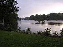
Bayou Bartholomew is the longest bayou in the world[1] meandering approximately 364 miles (586 km) between the U.S. states of Arkansas and Louisiana.[2] It contains over 100 aquatic species making it the second most diverse stream in North America. Known for its excellent bream, catfish, and crappie fishing, portions of the bayou are considered some of the best kept secrets of Arkansas anglers. It starts northwest of the city of Pine Bluff, Arkansas, in the Hardin community, winds through parts of Jefferson, Lincoln, Desha, Drew, Chicot, and Ashley counties in Arkansas, and Morehouse Parish, Louisiana, and eventually dumps into the Ouachita River after passing by the northernmost tip of Ouachita Parish, near Sterlington, Louisiana. The bayou serves as the primary border separating the Arkansas Delta from the Arkansas Timberlands.
The present bayou bed was formed by the waters of the Arkansas River during a period when it was constantly changing courses. Approximately 1,800 to 2,200 years ago, the river diverted from the present area of the bayou, and the leisurely bayou began to develop in the old river bed. Until construction of railroad lines in the area in the late 19th century, it was the most important stream for transportation in the interior Delta. It allowed the development of one of the richest timber and agricultural industries in the Delta area.
Once a pristine stream, it is now polluted, log-jammed, and over-sedimented in certain sections. In 1995, Dr. Curtis Merrell of Monticello (Drew County) organized the Bayou Bartholomew Alliance to "restore and preserve the natural beauty" of the bayou. With help from the Alliance, many government organizations (such as the Arkansas Game and Fish Commission, Arkansas Soil and Water Conservation Commission, Arkansas Department of Environmental Quality, USDA Natural Resources Conservation Service, Environmental Protection Agency, U.S. Fish and Wildlife Service), Ducks Unlimited, and the public, the bayou may eventually reclaim some of its grandeur. Projects underway include monitoring water quality, planting trees for buffer zones, restoring riparian sites ruined by clear-cutting, trash removal, removing log jams, bank stabilization, building boat ramps, and encouraging no-till farming.
Location
- Mouth
- Confluence with the Ouachita River in Morehouse Parish, Louisiana: 32°43′22″N 92°03′50″W / 32.72291°N 92.06402°W[3][4]
- Source
- Jefferson County, Arkansas: 34°17′01″N 92°10′11″W / 34.28355°N 92.16980°W[3][4]
Cultural references
Indie rock band The Weeks plays a song called "Bayou Bartholomew" in their EP album Rumspringa.
The Robert Hill Band,has an original slide guitar instrumental entitled, "Bayou Bartholomew", on their 2015 release, "Have Slide Will Travel." Hill is an Arkansas native,and award-winning slide guitarist/songwriter. http://roberthillband.com/
References
- ↑ "Bayou Bartholomew". Encyclopedia of Arkansas. Butler Center for Arkansas Studies. Retrieved 9 August 2014.
- ↑ U.S. Geological Survey. National Hydrography Dataset high-resolution flowline data. The National Map Archived 2012-04-05 at WebCite, accessed June 3, 2011
- 1 2 "Bayou Bartholomew". Geographic Names Information System. United States Geological Survey. Retrieved 2014-01-05.
- 1 2 "Bayou Bartholomew". Geographic Names Information System. United States Geological Survey. Retrieved 2014-01-05.
External links
- http://www.arkansasstripers.com/bartholomew.htm
- http://www.encyclopediaofarkansas.net/encyclopedia/entry-detail.aspx?entryID=2226