Bayerfeld-Steckweiler
| Bayerfeld-Steckweiler | ||
|---|---|---|
| ||
 Bayerfeld-Steckweiler | ||
Location of Bayerfeld-Steckweiler within Donnersbergkreis district 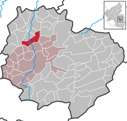 | ||
| Coordinates: 49°40′43″N 7°47′51.79″E / 49.67861°N 7.7977194°ECoordinates: 49°40′43″N 7°47′51.79″E / 49.67861°N 7.7977194°E | ||
| Country | Germany | |
| State | Rhineland-Palatinate | |
| District | Donnersbergkreis | |
| Municipal assoc. | Rockenhausen | |
| Government | ||
| • Mayor | Wolfgang Kraus | |
| Area | ||
| • Total | 8.60 km2 (3.32 sq mi) | |
| Population (2015-12-31)[1] | ||
| • Total | 399 | |
| • Density | 46/km2 (120/sq mi) | |
| Time zone | CET/CEST (UTC+1/+2) | |
| Postal codes | 67808 | |
| Dialling codes | 06362 | |
| Vehicle registration | KIB | |
| Website | rockenhausen.de | |

Bayerfeld-Steckweiler is a municipality in the Donnersbergkreis district, in Rhineland-Palatinate, Germany. Bayerfeld-Steckweiler has an area of 1.49 km² and a population of 148 (as of December 31, 2006).
References
- ↑ "Gemeinden in Deutschland mit Bevölkerung am 31. Dezember 2015" (PDF). Statistisches Bundesamt (in German). 2016.
This article is issued from Wikipedia - version of the 10/29/2016. The text is available under the Creative Commons Attribution/Share Alike but additional terms may apply for the media files.