Battle Creek, Nebraska
| Battle Creek, Nebraska | |
|---|---|
| City | |
|
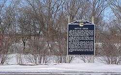
Historical marker at northern outskirts of Battle Creek, describing the 1859 events for which the creek and the city were named | |
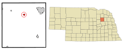 Location of Battle Creek, Nebraska | |
| Coordinates: 41°59′57″N 97°35′56″W / 41.99917°N 97.59889°WCoordinates: 41°59′57″N 97°35′56″W / 41.99917°N 97.59889°W | |
| Country | United States |
| State | Nebraska |
| County | Madison |
| Area[1] | |
| • Total | 0.71 sq mi (1.84 km2) |
| • Land | 0.71 sq mi (1.84 km2) |
| • Water | 0 sq mi (0 km2) |
| Elevation | 1,588 ft (484 m) |
| Population (2010)[2] | |
| • Total | 1,207 |
| • Estimate (2012[3]) | 1,210 |
| • Density | 1,700.0/sq mi (656.4/km2) |
| Time zone | Central (CST) (UTC-6) |
| • Summer (DST) | CDT (UTC-5) |
| ZIP code | 68715 |
| Area code(s) | 402 |
| FIPS code | 31-03250 |
| GNIS feature ID | 0827218[4] |
Battle Creek is a city in Madison County, Nebraska, United States. It is part of the Norfolk, Nebraska Micropolitan Statistical Area. The population was 1,207 at the 2010 census.
History
In 1859, following complaints of Pawnee depredations against settlers in the Elkhorn River valley, a combined force of Nebraska Territorial Militia under the command of General John Milton Thayer and 2nd U.S. Army Dragoons under Lieutenant Beverly Holcombe Robertson prepared to attack a Pawnee village. Rather than fighting, the Pawnees surrendered before the attack could be launched. Chief Petalesharu draped an American flag over his shoulders and held a peace pipe while confronting the soldiers to stop the fight from taking place, [5] ending the Pawnee War of 1859. Although no battle occurred, the nearby stream was dubbed Battle Creek.[6] The town founded in the area in 1867 took the creek's name for itself.[7]
Geography
Battle Creek is located at 41°59′57″N 97°35′56″W / 41.99917°N 97.59889°W (41.999047, -97.599005).[8]
According to the United States Census Bureau, the city has a total area of 0.71 square miles (1.84 km2), all of it land.[1]
Demographics
| Historical population | |||
|---|---|---|---|
| Census | Pop. | %± | |
| 1880 | 123 | — | |
| 1890 | 352 | 186.2% | |
| 1900 | 506 | 43.8% | |
| 1910 | 597 | 18.0% | |
| 1920 | 743 | 24.5% | |
| 1930 | 755 | 1.6% | |
| 1940 | 702 | −7.0% | |
| 1950 | 630 | −10.3% | |
| 1960 | 587 | −6.8% | |
| 1970 | 768 | 30.8% | |
| 1980 | 948 | 23.4% | |
| 1990 | 997 | 5.2% | |
| 2000 | 1,158 | 16.1% | |
| 2010 | 1,207 | 4.2% | |
| Est. 2015 | 1,193 | [9] | −1.2% |
| U.S. Decennial Census[10] 2012 Estimate[11] | |||
2010 census
As of the census[2] of 2010, there were 1,207 people, 457 households, and 321 families residing in the city. The population density was 1,700.0 inhabitants per square mile (656.4/km2). There were 480 housing units at an average density of 676.1 per square mile (261.0/km2). The racial makeup of the city was 97.8% White, 0.1% African American, 1.2% Native American, 0.1% Asian, 0.5% from other races, and 0.4% from two or more races. Hispanic or Latino of any race were 0.8% of the population.
There were 457 households of which 39.2% had children under the age of 18 living with them, 59.1% were married couples living together, 7.7% had a female householder with no husband present, 3.5% had a male householder with no wife present, and 29.8% were non-families. 25.8% of all households were made up of individuals and 14% had someone living alone who was 65 years of age or older. The average household size was 2.55 and the average family size was 3.08.
The median age in the city was 39.7 years. 28.1% of residents were under the age of 18; 5.9% were between the ages of 18 and 24; 23.4% were from 25 to 44; 24.9% were from 45 to 64; and 17.6% were 65 years of age or older. The gender makeup of the city was 48.2% male and 51.8% female.
2000 census
As of the census of 2000, there were 1,158 people, 434 households, and 325 families residing in the city. The population density was 1,784.6 people per square mile (687.9/km²). There were 447 housing units at an average density of 688.9 per square mile (265.5/km²). The racial makeup of the city was 97.41% White, 0.09% African American, 1.38% Native American, 0.43% from other races, and 0.69% from two or more races. Hispanic or Latino of any race were 1.04% of the population.
There were 434 households out of which 40.6% had children under the age of 18 living with them, 61.8% were married couples living together, 9.7% had a female householder with no husband present, and 25.1% were non-families. 23.3% of all households were made up of individuals and 13.4% had someone living alone who was 65 years of age or older. The average household size was 2.67 and the average family size was 3.14.
In the city the population was spread out with 31.1% under the age of 18, 6.6% from 18 to 24, 28.8% from 25 to 44, 18.7% from 45 to 64, and 14.8% who were 65 years of age or older. The median age was 35 years. For every 100 females there were 96.3 males. For every 100 females age 18 and over, there were 90.0 males.
As of 2000 the median income for a household in the city was $43,906, and the median income for a family was $50,179. Males had a median income of $34,792 versus $20,536 for females. The per capita income for the city was $16,996. About 4.3% of families and 6.7% of the population were below the poverty line, including 5.4% of those under age 18 and 8.1% of those age 65 or over.
References
- 1 2 "US Gazetteer files 2010". United States Census Bureau. Archived from the original on 2012-01-24. Retrieved 2012-06-24.
- 1 2 "American FactFinder". United States Census Bureau. Retrieved 2012-06-24.
- ↑ "Population Estimates". United States Census Bureau. Archived from the original on 2013-06-17. Retrieved 2013-05-29.
- ↑ "US Board on Geographic Names". United States Geological Survey. 2007-10-25. Retrieved 2008-01-31.
- ↑ "bcps.esu8.org" Archived August 20, 2014, at the Wayback Machine.
- ↑ "Battle Creek, Madison County". Center for Advanced Land Management Information Technologies. University of Nebraska. Retrieved 19 August 2014.
- ↑ "Battle Creek". Nebraska State Historical Society. Retrieved 2010-03-06.
- ↑ "US Gazetteer files: 2010, 2000, and 1990". United States Census Bureau. 2011-02-12. Retrieved 2011-04-23.
- ↑ "Annual Estimates of the Resident Population for Incorporated Places: April 1, 2010 to July 1, 2015". Retrieved July 2, 2016.
- ↑ United States Census Bureau. "Census of Population and Housing". Archived from the original on May 11, 2015. Retrieved November 13, 2013.
- ↑ "Annual Estimates of the Resident Population: April 1, 2010 to July 1, 2012". Retrieved November 13, 2013.
Municipalities and communities of Madison County, Nebraska, United States | ||
|---|---|---|
| Cities | ||
| Village | ||
| Unincorporated communities | ||
| Footnotes | ‡This populated place also has portions in an adjacent county or counties | |