Basse-Terre Island
- For the largest city on the island of Basse-Terre and capital of Guadeloupe, see Basse-Terre. For the capital of Saint Kitts and Nevis see Basseterre.
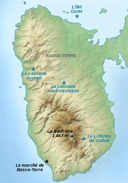 Map of places of interest in Basse-Terre, the western part of Guadeloupe, a French Antilles island. | |
 | |
| Geography | |
|---|---|
| Location | Caribbean Sea |
| Coordinates | 16°08′58″N 61°40′41″W / 16.14944°N 61.67806°WCoordinates: 16°08′58″N 61°40′41″W / 16.14944°N 61.67806°W |
| Archipelago | Leeward Islands |
| Area | 847.8 km2 (327.3 sq mi) |
| Highest elevation | 1,467 m (4,813 ft) |
| Highest point | Soufrière |
| Administration | |
|
France | |
| Overseas department | Guadeloupe |
| Largest settlement | Baie-Mahault (pop. 28,893 as 2007) |
| Demographics | |
| Population | 186,661 (2006) |
| Pop. density | 220 /km2 (570 /sq mi) |
| Ethnic groups | Black / Mulatto 76%, White 4%, from Tamil Nadu and other parts of India 18%, Lebanese / Syrians 1%, Chinese / others 1% |
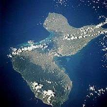
Basse-Terre Island (French: île de Basse-Terre or île de la Basse-Terre) is the name of the western-half of Guadeloupe proper, in the Lesser Antilles. To the South lies Les Saintes and Dominica. In the North-East, it is separated from the other half of Guadeloupe proper, Grande-Terre, by a narrow sea channel called the Rivière Salée (in English Salt River).
Basse-Terre Island has a land area of 847.8 km2 (327.3 sq mi). At the 2006 census the population of Basse-Terre Island was 186,661 inhabitants living in 16 communes (municipalities). The population density was 220 inhabitants per square kilometre (570/sq mi). The largest city on Basse-Terre Island is the city of Basse-Terre which had 37,455 inhabitants in its urban area at the 2006 census. The city of Basse-Terre is the prefecture (capital) of Guadeloupe.
Name
Despite its name, Basse-Terre Island (literally "Low Land" Island, "Down Land" Island) is the highest island of Guadeloupe, rising to 1,467 metres (4,813 feet) above sea level at the Soufrière volcano. The name of the island is the result of French terminology used in the Caribbean in the 17th century. In the Caribbean, the prevailing winds blow from the northeast (see trade wind), thus the western side of the Caribbean islands, the leeward side (in French, côte sous le vent), protected from the trade winds, was called the Basse-Terre ("Down Land") in 17th-century French because it is situated downwind compared to the eastern side of the Caribbean islands, the windward side (in French, côte au vent), which is exposed to the trade winds and was called the Cabesterre.
This distinction between a Basse-Terre (western side of an island) and a Cabesterre (eastern side of an island) was used in several Caribbean islands colonized by France. The capital of Saint Kitts and Nevis, for example, was named Basseterre because it is located on the western side of the island of Saint Kitts. Basse-Terre Island was originally called "Guadeloupe" (a name which did not originally include the sister island of Grande-Terre) and as in other French Caribbean islands its western side was called Basse-Terre while its eastern side was called Cabesterre. The capital and main settlement of Guadeloupe was established on the Basse-Terre side of the island in the 17th century and was simply called the city of Basse-Terre (in the same way as what happened in Saint Kitts). Later in the 18th century, the entire island (and not just its western side) came to be known as Basse-Terre Island, probably under the influence of its largest settlement the city of Basse-Terre, and the name Guadeloupe was then used for the combined islands of Basse-Terre Island and Grande-Terre.
Geography
La Grande Soufrière, the tallest mountain in the Lesser Antilles, is located on the island. It rises to 1,467 m (4,813 ft) high and is an active volcano. The surrounding area of Basse-Terre has a rough volcanic relief fertile land. The surrounding areas of Basse-Terre consists of forest, grassland and sugar, coffee, banana and cocoa plantations. The island has a land area of 847.8 km2 (327.3 sq mi).
The eastern coast of Basse-Terre Island, known as the Windward Coast (in French, Côte-au-vent), is exposed to the trade winds and receives a lot of rain, whereas the western coast of the island, known as the Leeward Coast (in French, Côte-sous-le-vent) is protected from the winds by the Soufrière volcano and is thus much drier.
Towns
The most populated communes (municipalities) on the island are, in descending order of population, Baie-Mahault (western part of Pointe-à-Pitre urban area), Petit-Bourg, Capesterre-Belle-Eau, Sainte-Rose, Lamentin, Basse-Terre, and Saint-Claude (part of Basse-Terre urban area).
Sights
Above the city of Basse-Terre on a mountain road, is the village of Saint-Claude, at the base of the Soufrière volcano. The village is noted for its coffee and banana plantations & stately homes. Tours to ascend the Soufrière can be arranged. The starting point is at Saint-Claude. The volcano is currently dormant.
About three miles (4.8 km) east, is the village of Gourbeyre where Fort Louis Delgres was built in 1650 by Charles Houël. This fort guarded the approach to the city of Basse-Terre and served in several battles against the British.
About eight miles (13 km) south-south-east is the village of Trois-Rivières, a fishing community rich in ancient settlements of the peaceful Arawaks. Near the village is an archaeological park which features sculpted and engraved rocks and relics left by the Arawaks in a grotto deep in the forest.
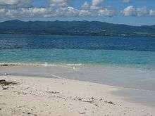
A few beaches are located along the coast, north and south of the city of Basse-Terre. There are also fishing areas.
| Wikimedia Commons has media related to Basse-Terre. |