Barton, North Yorkshire
| Barton | |
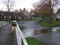 A ford at Barton, near the village green. |
|
 Barton |
|
| Population | 837 (2011) |
|---|---|
| OS grid reference | NZ230088 |
| District | Richmondshire |
| Shire county | North Yorkshire |
| Region | Yorkshire and the Humber |
| Country | England |
| Sovereign state | United Kingdom |
| Post town | DARLINGTON |
| Postcode district | DL10 6 |
| Police | North Yorkshire |
| Fire | North Yorkshire |
| Ambulance | Yorkshire |
| EU Parliament | Yorkshire and the Humber |
| UK Parliament | Richmond (Yorks) (UK Parliament constituency) |
Coordinates: 54°28′28″N 1°38′43″W / 54.47454°N 1.64522°W
Barton is a village and civil parish in the Richmondshire district of North Yorkshire, England. According to the 2011 census it had a population of 837.[1] It is situated near the border with the ceremonial county of County Durham, and is 6 miles south-west of Darlington.
History
The village is recorded as Bartun in the Domesday Book. At the time of the Norman invasion the manor was split between Earl Edwin and Ulf. Afterwards it was granted to Count Alan of Brittany. In turn he granted the manor to Godric, the steward.[2] The manor was split, unified and then split again during the 13th century. At the time of Henry III, the manor was following the descent of Richmond. In 1227, part of the lands were granted to Richard of Cornwall and then to Peter de Brus, lord of Skelton. The manor was further split into mesne lordships, of which Roald of Richmond held one in 1286 and which then followed the descent of the Scropes of Bolton. Other parts of the manor were granted to William de Lancaster around 1235. By 1330 the lands had passed to the Mowbray family. When their direct descent ended in 1391, the manor was passed to the Ingleby's of Ripley. In 1579 this line too ended and the land passed to John Ward who descendents via marriages included the Dodsworth and Killinghall families until 1762. The second part of the manor was passed to John de Huddleston around 1316. These eventually passed to the descendants of the manors of Barforth and Cleasby. The remaining mesne lordship was held Raplh, son of Ranulph of Richmond in 1268 and passed eventually to the Wandesford family and finally to the Dodsworths[3][4]
The etymology of the name of the village is derived from the Old English phrase bere-tūn, initially meaning barley farm, but later came to mean a demense farm or outlying grange.[5][6]
Governance
The village lies within the Richmond UK Parliament constituency. It also lies within the Richmondshire North electoral division of North Yorkshire County Council and the Barton ward of Richmondshire District Council.[7] An electoral ward in the same name exists. This ward stretches north-east to Cleasby with a total population taken at the 2011 Census of 1,224.[8]
Geography
The village lies 1 mile (1.6 km) east of the old Roman road of Watling Street.[3][4] The village of Newton Morrell is the closest to Barton at just 0.77 miles (1.24 km) to the north-east and Stapleton 2 miles (3.2 km) northward. Other settlements that are close by include Melsonby 2 miles (3.2 km) to the west, Middleton Tyas 1.7 miles (2.7 km) to the south and Aldbrough St John 2.4 miles (3.9 km) to the north-west. Barton Beck flows north through the centre of the village creating a ford across Mary Gate. It joins Clow Beck on the north side of the nearby A1(M and is part of the tributary system of the River Tees.[7]
Demography

| Population[9][10][11] | ||||||||||
|---|---|---|---|---|---|---|---|---|---|---|
| Year | 1881 | 1891 | 1901 | 1911 | 1921 | 1931 | 1951 | 1961 | 2001 | 2011 |
| Total | 515 | 410 | 517 | 558 | 553 | 575 | 540 | 505 | 880 | 837 |
2001 census
The 2001 UK census showed that the population was split 47.8% male to 52.2% female. The religious constituency was made of 83.1% Christian, 0.3% Jewish, 0.6% Muslim and the rest stating no religion or not stating at all. The ethnic make-up was 98.9% White British, 0.5% Mixed ethnic and 0.7% White other. There were 376 dwellings.[10]
2011 census
The 2011 UK census showed that the population was split 48.4% male to 51.6% female. The religious constituency was made of 77.3% Christian, 0.1% Muslim and the rest stating no religion or not stating at all. The ethnic make-up was 98% White British, 0.1% Mixed ethnic, 0.1% British Asian, 0.1% British Black and 1% each White Other . There were 386 dwellings.[11]
Community and culture
Education in the village is provided by Barton CE Primary School.[12] Pupils would then receive secondary education at Richmond School & Sixth Form College.[13] There is a public house and a local village store incorporating a post office. The village is home to Barton Cricket Club who play at the playing fields on Church Lane. They compete in the Darlington and District League.[14] In 2007, the then Barton Cricket Club wicket-keeper, David Morrison, was featured in an article in the Daily Mail national newspaper, when he reluctantly had to visit hospital after an injury during a match which revealed he had been playing for years with broken bones in every finger and thumb.[15]
Religion
There is a church dedicated to St Cuthbert and St Mary in the village, located on Church Lane. The Grade II Listed building dates from 1840 when the two parishes of both the named Saints were brought together due to the ruinous state of both buildings.[3][4][16] There is also a Methodist Chapel located in Church Row that was built in 1829 and repaired in 1878.[4]
References
- ↑ "Civil Parish 2011". Neighbourhood Statistics. Office for National Statistics. Retrieved 4 February 2016.
- ↑ Barton in the Domesday Book. Retrieved 6 April 2013.
- 1 2 3 "History". Retrieved 28 May 2013.
- 1 2 3 4 Bulmer's Topography, History and Directory (Private and Commercial) of North Yorkshire 1890. S&N Publishing. 1890. pp. 357–358. ISBN 1-86150-299-0.
- ↑ Watts (2011). Cambridge Dictionary of English Place-names. Cambridge University Press. p. 39. ISBN 978-0521168557.
- ↑ A.D. Mills (1998). Dictionary of English Place-Names. Oxford Paperbacks. p. 44. ISBN 978-0192800749.
- 1 2 Ordnance Survey Open Viewer
- ↑ "Ward population 2011". Retrieved 7 August 2015.
- ↑ "Population at Cenuses". Vision of Britain. 2009. Retrieved 22 March 2013.
- 1 2 "2001 UK Census". Neighbourhood Statistics. Office for National Statistics. 2002. Retrieved 25 March 2013.
- 1 2 "2011 UK Census". Neighbourhood Statistics. Office for National Statistics. 2013. Retrieved 25 March 2013.
- ↑ "Primary School". Retrieved 6 April 2013.
- ↑ "Secondary admission arrangements for the Northallerton area". North Yorkshire County Council. Retrieved 17 November 2016.
- ↑ "Barton Cricket Club". England & Wales Cricket Board (ECB). Retrieved 17 November 2016.
- ↑ "Wicket Keepers Painful Story". The Daily Mail. Retrieved 28 May 2013.
- ↑ "St Cuthberts Listing Status". Retrieved 28 May 2013.
External links
-
 Media related to Barton, North Yorkshire at Wikimedia Commons