Barraba Shire
| Barraba Shire Queensland | |||||||||||||
|---|---|---|---|---|---|---|---|---|---|---|---|---|---|
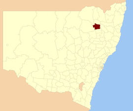 Location within New South Wales | |||||||||||||
| Population | 2,185 (2004)[1] | ||||||||||||
| • Density | 0.71203/km2 (1.8441/sq mi) | ||||||||||||
| Established | 1906 | ||||||||||||
| Area | 3,068.7 km2 (1,184.8 sq mi) | ||||||||||||
| Council seat | Barraba | ||||||||||||
| Region | New England | ||||||||||||
|
| |||||||||||||
| |||||||||||||
Barraba Shire was a local government area located in the New England region of New South Wales, Australia, about 90 kilometres (56 mi) north of Tamworth via Fossickers Way. The Shire, administered from the town of Barraba covered an area of 3,068.7 square kilometres (1,184.8 sq mi), and existed as a local government entity from 1906 until 2004, when it was split between two new LGAs, Gwydir Shire and Tamworth Regional Council.
History
In 1897, a progress association was brought into being by local residents to advocate for the area and to manage infrastructure. With the passage of the Local Government Act 1906, which established shires all over New South Wales, the Barraba Shire was gazetted on 6 March 1906. As the town met the requirements for municipality status, it was separately gazetted as the Barraba Municipality on 19 May 1906.[2] S. J. Lillis was elected the municipality's first mayor, while John Morrow became the first Barraba Shire president.[3]
On 1 November 1953, the Barraba Municipality was abolished and the town came under the Shire's authority.[4]
On 17 March 2004, Barraba Shire was abolished. 1,259.1 square kilometres (486.1 sq mi) (41%) of its area and 340 people in the Shire's north were transferred to the new Gwydir Shire, composed otherwise of the former Yallaroi and Bingara Shires. The rest, including the town of Barraba, was transferred to the new Tamworth Regional Council, formed from the former City of Tamworth and the Shires of Manilla, Nundle and most of Parry.
Towns
- Barraba
- Banoon
- Cobbadah †
- Gulf Creek †
- Gundamulda †
- Ironbark
- Lindesay †
- Longarm
- Mayvale
- Red Hill
- Upper Horton †
- Woodsreef
† Transferred to Gwydir upon abolition.
Population
| Year | Population |
|---|---|
| 1933 | 3,550 |
| 1947 | 3,088 |
| 1954 | 3,234 |
| 1961 | 2,952 |
| 1966 | 2,815 |
| 1971 | 3,035 |
| 1976 | 3,246 |
| 1981 | 2,933 |
| 1986 | 2,687 |
| 1991 | 2,467 |
| 1996 | 2,264 |
| 2001 | 2,136 |
References
- ↑ Australian Bureau of Statistics (23 March 2005). "3218.0 — Regional Population Growth, Australia and New Zealand, 2003-04 — New South Wales". Retrieved 17 June 2011.
- ↑ NSW Government Gazette, 19 May 1906, p.3044.
- ↑ Boileau, Joanne (February 2007). Thematic history of Nundle, Manilla and Barraba (PDF). Retrieved 17 June 2011.
- ↑ Commonwealth Bureau of Census and Statistics (21 September 1955). Census of the Commonwealth of Australia, 30th June, 1954 (Volume 1, Part 1). p. 4.
Coordinates: 30°23′42″S 150°34′05″E / 30.395°S 150.568°E