Barnton, Cheshire
- For the area of Edinburgh, see Barnton, Edinburgh
| Barnton | |
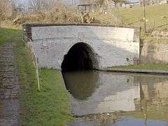 Barnton Tunnel |
|
 Barnton |
|
| Population | 5,614 (2011)[1] |
|---|---|
| OS grid reference | SJ633745 |
| – London | 183 miles (295 km) |
| Civil parish | Barnton |
| Unitary authority | Cheshire West and Chester |
| Shire county | Cheshire |
| Region | North West |
| Country | England |
| Sovereign state | United Kingdom |
| Post town | NORTHWICH |
| Postcode district | CW8 |
| Dialling code | 01606 |
| Police | Cheshire |
| Fire | Cheshire |
| Ambulance | North West |
| EU Parliament | North West England |
| UK Parliament | Tatton |
| Website | www.barntonvillage.org.uk |
Coordinates: 53°16′00″N 2°33′00″W / 53.266667°N 2.55°W
Barnton is a civil parish and village in the north-west of England, just outside the town of Northwich, in the unitary authority of Cheshire West and Chester and the ceremonial county of Cheshire. It lies north and east of the Trent & Mersey Canal which goes through two tunnels (Barnton and Saltersford) to the west of the village.
Barnton boasts an excellent range of local amenities and is within easy reach of the A49, M56 and M6 making it popular with commuters to Liverpool, Manchester and Chester. It is surrounded by wonderful Cheshire countryside and enjoys an enviable location on some of Cheshire’s most attractive inland waterways.
The village can roughly be divided into four parts: the old village which grew northeast-wards from the south west corner; the more up-market properties northwest-wards along and to the west of the main Runcorn Road (A533); the council-built estate to the north west, largely between Townfield Lane and Runcorn Road; and the more modern estates (the largest known as the Locke estate after the builders) to the north and east. The village has no easily identifiable centre with some shops along the Runcorn Road and others by the new Health Centre in Lydyett Lane. There are currently only two pubs, a small number for such a large village and greatly fewer than there were 100 years ago. The parish church is Christ Church in Church Road in the old part of the village; there are also Catholic, Methodist and Pentecostal churches.
Barnton F.C. were founder members of the Mid Cheshire Football League and now compete in the North-West counties league. The new village hall (the Memorial Hall) is located within the Barnton F.C. ground off Townfield Lane. The village also has a cricket club which is located close to Barnton School which is also in Townfield Lane.
Below the village where the main A533 crosses the River Weaver, a battle was fought during the English Civil War.[2] A plaque marking this was until recently mounted on the bridge stonework.This has now been replaced.
The Parish Church, Christ Church, Barnton was completed in 1842 and the Vicarage stands proudly on Church Road overlooking the former Brunner Mond chemical works. Further along at Church Road junction stands the old Police Station which was built in 1902 for the sergeant who lived on Bells Brow. It contained an office, an interview room and three cells. There is still has a row of back-to-back houses on Bell’s Brow at the top of Barnton Hill built in 1810 to accommodate Brunner Mond labourers.
Barnton became known as "Jam Town" in the late 1800s due to so many people owning and not renting their homes. "People in Barnton eat Jam butties so that they can own not only their own houses, but buy their neighbours too!"[3]
See also
Footnotes
- ↑ "Parish population 2011". Retrieved 29 May 2015.
- ↑ "Sealed Knot's Entry for Battle of Winnington Bridge".
- ↑ "Barnton Parish Council". Archived from the original on 15 July 2014. Retrieved 12 June 2014.
External links
| Wikimedia Commons has media related to Barnton. |
Cheshire Portal | |
| Unitary authorities | |
| Major settlements | |
| Rivers | |
| Topics | |