Barnsley Canal
| Barnsley Canal | |
|---|---|
|
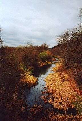
The canal in Haw Park Woods near Wakefield | |
| Specifications | |
| Length | 14.5 miles (23.3 km) |
| Maximum boat length |
84 ft 0 in (25.60 m) (originally 66 ft 0 in or 20.12 m) |
| Maximum boat beam | 14 ft 0 in (4.27 m) |
| Locks | 17 |
| Status | Restoration proposed |
| History | |
| Original owner | Barnsley Canal Company |
| Principal engineer | Samual Hartley |
| Date of act | 1793 |
| Date of first use | 1799 |
| Date completed | 1802 |
| Date closed | 1893, 1946 |
| Geography | |
| Start point | Barnsley |
| End point | Heath Common |
| Branch of | Aire and Calder Navigation |
| Connects to | Dearne and Dove Canal |
Barnsley Canal | |||||||||||||||||||||||||||||||||||||||||||||||||||||||||||||||||||||||||||||||||||||||||||||||||||||||||||||||||||||||||||||||||||||||||||||||||||||||||||||||||||||||||||||||||||||||||||||||||||||||||||||||||||||||||||||||||||||||||||||||||||||||||||||||||||||||||
|---|---|---|---|---|---|---|---|---|---|---|---|---|---|---|---|---|---|---|---|---|---|---|---|---|---|---|---|---|---|---|---|---|---|---|---|---|---|---|---|---|---|---|---|---|---|---|---|---|---|---|---|---|---|---|---|---|---|---|---|---|---|---|---|---|---|---|---|---|---|---|---|---|---|---|---|---|---|---|---|---|---|---|---|---|---|---|---|---|---|---|---|---|---|---|---|---|---|---|---|---|---|---|---|---|---|---|---|---|---|---|---|---|---|---|---|---|---|---|---|---|---|---|---|---|---|---|---|---|---|---|---|---|---|---|---|---|---|---|---|---|---|---|---|---|---|---|---|---|---|---|---|---|---|---|---|---|---|---|---|---|---|---|---|---|---|---|---|---|---|---|---|---|---|---|---|---|---|---|---|---|---|---|---|---|---|---|---|---|---|---|---|---|---|---|---|---|---|---|---|---|---|---|---|---|---|---|---|---|---|---|---|---|---|---|---|---|---|---|---|---|---|---|---|---|---|---|---|---|---|---|---|---|---|---|---|---|---|---|---|---|---|---|---|---|---|---|---|---|---|---|---|---|---|---|---|---|---|---|---|---|---|---|---|---|---|
Legend
| |||||||||||||||||||||||||||||||||||||||||||||||||||||||||||||||||||||||||||||||||||||||||||||||||||||||||||||||||||||||||||||||||||||||||||||||||||||||||||||||||||||||||||||||||||||||||||||||||||||||||||||||||||||||||||||||||||||||||||||||||||||||||||||||||||||||||
The Barnsley Canal is a canal that ran from Barnby Basin, through Barnsley, South Yorkshire, England to a junction with the Aire and Calder Navigation near Wakefield. It was 14.5 miles (23.3 km) long and included 15 locks. It was taken over by the Aire and Calder Navigation in 1854, and despite competition from the railways, and structural damage from subsidence, remained profitable until 1942. It was abandoned in 1953, after major breaches occurred in 1945 and 1946, and is currently disused, although there are proposals from the Barnsley Canal Consortium to restore and reopen it.
History
The early 1790s were a time when there was an increasing demand for coal, but a shortage in many places because much of the coal being produced was being consumed by industries close to the mines. There were coal reserves near Barnsley, but no transport links to distribute it to the region. In July 1792, the Aire and Calder Canal Company asked William Martin, who was the manager of the canal, to prepare plans for a link from near Wakefield to the Barnsley mines. Hearing of the plans, the River Don Navigation Company proposed an alternative, which involved the canalisation of the River Dearne, to reach the same destination. The Aire and Calder scheme foresaw a healthy trade in coal and manufactured goods from Barnsley to the Aire and Calder, and agricultural lime from Knottingley in the reverse direction.[1]
Martin and the Aire and Calder's resident engineers surveyed the route, and at a public meeting held on 20 September 1792, the canal engineer William Jessop suggested that the line from just below Wakefield to Barnsley and Silkstone could be built for approximately £50,000. The Aire and Calder decided to subscribe £20,000 for shares, to ensure that they held a majority shareholding. A further meeting in mid-October reported that the cost was now £60,000, and that 86 people had subscribed to it. The River Don company attended the meeting, as they were keen to use the Barnsley to Silkstone route for their Dearne and Dove Canal, but an agreement was reached, whereby the Barnsley Canal company would build the Barnby to Barnsley section, but no water would be taken from the River Dearne, which was needed to supply the Dearne and Dove canal. A 2.5-mile (4.0 km) branch from Barugh to Haigh Bridge, including an extra seven locks, was added to the scheme.[2]
The Aire and Calder proposed to pump all the water for the canal from the River Calder, using steam-driven pumps at Agbrigg, Walton and Barugh. The Haigh branch would have required a fourth engine, but the Haigh furnace closed and the branch was never built. The pumps at Walton and Agbrigg were replaced by a reservoir at Cold Hiendley, which increased the construction costs by £3,000, but reduced running costs by £350 per year.[3] An Act of Parliament was obtained on 3 June 1793, which created the company and authorised them to raise £72,000 by the issuing of shares, with an additional £25,000 by shares or by mortgage if it was required.[4] The Dearne and Dove canal was authorised on the same day.[5]
Construction
Construction work started on 27 September 1793, at Heath Common, near the junction with the Aire and Calder Canal. Samual Hartley was the engineer, and John Pinkerton was contracted to build the canal. Construction was difficult, with Pinkerton unexpectedly encountering rock in the cutting at Cold Hiendley, and inflation pushed up the costs. There were disputes between Hartley and Pinkerton, which lasted until long after the canal was opened, and were finally settled in 1812, after a lawsuit. The northern section to Barnsley opened on 8 June 1799, while the Barnsley to Barnby section was not started until late 1798, and did not open until early 1802. The Dearne and Dove Canal was completed in late 1804.[6]
The cost of construction was £95,000. The original scheme envisaged a number of tramways to connect to the coal mines, but none of these were built initially. Major engineering features included a five-arched aqueduct where the canal crossed the River Dearne, a long cutting at Cold Hiendley, five locks at Barugh, another twelve at Walton, two at Agbrigg and the final one near Heath. This lock was situated at the end of a cut, which frequently filled with rubbish, and so it was replaced in 1816 by a new lock much closer to the Aire and Calder.[7] The Wintersett reservoir covered an area of 80 acres (32 ha) when first built, which increased to 127 acres (51 ha) when its banks were raised by 4 feet (1.2 m)[4] in 1807. In 1803, a pumping station was built at Ryhill, using a Cornish beam engine obtained from Harveys of Hayle, which pumped surplus water from the canal up into the reservoir.[8] Land for a second reservoir at Cold Hiendley was obtained in 1840, and it was built in 1854. It was located between Wintersett Reservoir and the canal, but was at a lower level, and the pumping station was modified so that water could also be pumped from the new reservoir into the canal. The Cold Hiendley reservoir was enlarged to cover 55 acres (22 ha) in 1874.[9] The beam engine, which was probably second-hand in 1803, gave good service and lasted until the closure of the canal in 1946.[8]
Traffic
The canal was principally designed to carry coal from collieries in the Barnby region. The Low Moor Company had a colliery at Barnby Furnace, and constructed a 0.5-mile (0.80 km) tramway between there and Barnby basin, which was carrying coal by 1802. By 1804, around 10,000 tons was leaving the colliery, although the Dearne and Dove Canal had opened in late 1803, and only about half of the trade travelled the full length of the canal to the Aire and Calder. Coal from the Silkstone collieries was sporadic, as the tramway which had been authorised by the Act of Parliament was not built due to financial constraints. The Barnby Furnace mine failed in 1806, and the company found itself with no money and little traffic. It obtained a new Act of Parliament on 28 March 1808, authorising it to raise another £43,000 in share capital, and £10,000 by mortgage. They were also able to raise the tolls.[4]
The tramway to Silkstone was completed in 1810. Barnby basin was enlarged to cope with the expected trade, which grew steadily. Coal accounted for just 23 per cent of the 22,270 tons carried in 1800, but had risen to 109,945 tons out of a total of 181,063 tons by 1821. The other main cargoes were corn and limestone. Receipts also rose, from £2,028 in 1803 to 7,649 in 1821, the latter figure being supplemented by a further £2,094 raised from tramway tolls. Profits were sufficient to pay dividends from 1810. In order to keep the boats moving, the Barnsley Canal Company attempted to take water from the River Dearne on several occasions, and were ordered to remove the works which diverted the water by the River Don Navigation Company, who had sponsored the Dearne and Dove Canal. A compromise was reached in 1812, which allowed some of the Dearne water to be used by the Barnsley canal.[10] Between 1828 and 1830, a number of bridges were raised, to allow larger vessels, called "Billy-boys", to use the canal.[11]
Competition

Competition in the form of railways started to affect the canal from the 1840s. The canal company initially welcomed some of the schemes, but the Don Navigation Company proposed to lease the canal for a year in 1845 and then to buy it, in order to prevent the railways gaining access to the Silkstone coal resources, and to protect the water supplies. They quickly offered to pass the canal on to the Aire and Calder Company, and to buy the Dearne and Dove Canal, but although they took over the Dearne and Dove Canal from 1 January 1846, they dropped their ideas for the Barnsley Canal. The Barnsley Canal Company then tried to arrange a lease with the Aire and Calder, but negotiations foundered.[1] A series of negotiations took place with the Yorkshire Railway Company, the Manchester, Sheffield and Lincolnshire Railway and the Aire and Calder Navigation between 1846 and 1853. It was not until 1854 that the company finally agreed to a lease from the Aire and Calder, by which time traffic was falling rapidly. The takeover was ratified by an Act of Parliament in 1856, although the Barnsley Canal Company was not wound up, as it continued to collect the rent from the lease.[12]
By reducing tolls, the Aire and Calder managed to increase traffic from 179,295 tons in 1855 to 291,313 tons in 1863, but traffic gradually reduced after that, as railway links to the coalfields were built. The canal structures were increasingly affected by subsidence from the mining, and an inspection of the aqueduct in 1866 revealed "fissures in the rock and cracks in the arches". In 1870, Barnsley Corporation ordered the canal company to stop extracting water from the River Dearne, as they needed the supply. Faced with a dilemma, the Barnsley and the Aire and Calder companies negotiated, and the result was the Barnsley Canal Transfer Act of 1871, which authorised the takeover of the canal by the Aire and Calder, the replacing of ten of the twelve Walton locks by an inclined plane, and protection of the water supply at Barugh.[13]
The locks below Cold Hiendley were lengthened from 66 feet (20 m) to 84 feet (26 m) between 1879 and 1881, but by this time there was little traffic on the upper section.[14] The final 1.3-mile (2.1 km) section to Barnby, including the five locks at Barugh were abandoned under the terms of the Aire and Calder Act 1893.[15] Powers to build the inclined plane were renewed in 1889, but no construction took place. Despite railway competition, the canal still carried in excess of 200,000 tons per year between 1885 and 1909.[16]
Decline
A major breach of the canal occurred on 20 November 1911, when subsidence caused part of the aqueduct and the adjacent embankment to fail. Repairs were not completed until 10 July 1912, when the canal was reopened. The canal had to close for four months at the end of 1922 due to drought conditions. In 1934, the County Council installed an electric lift bridge at Royston. Traffic continued to fall, and maintenance costs increased as the effects of subsidence damaged the infrastructure, but the canal remained profitable until 1942. The following year, the Royston bridge was operated 856 times to allow boats to pass. Mottram Wood colliery was flooded on 13 June 1945, when another leak occurred near the aqueduct, and in 1946, 53 million imperial gallons (240,000 m3) of water escaped from the canal on 22 November, flooding a housing estate and the surrounding countryside. The Aire and Calder applied to abandon the canal in May 1947,[16] and although the fledgeling Inland Waterways Association campaigned for its retention, the Docks and Inland Waterways Executive (DIWE) expressed "grave doubts as to whether it would be in the national interest to reinstate the waterway." The DIWE then offered compensation to carriers who were affected by the closure,[17] and the abandonment order was finally granted in 1953. The aqueduct was demolished immediately, as it was deemed to be unsafe.[18]
Restoration
The line of the canal below Barugh has remained largely intact, and in April 1984, the Barnsley Canal Group was formed, with the aim of campaigning for the restoration of the canal.[19] Their first task was to undertake a detailed survey of the canal, to confirm that restoration was at least realistic.[20] Having become a Limited Company and obtaining charitable status in April 1991, the group reformed as the Barnsley, Dearne and Dove Canal Trust in June 2000. In May 2001, the Barnsley Canal Consortium,[19] consisting of a working group which includes local authorities, the Inland Waterways Association and the Canal Trust, was formed. The Consortium employed professional engineers to carry out a feasibility study on the reopening of both the Barnsley Canal and the Dearne and Dove Canal in August 2004, and the report, which was published in November 2006[21] confirmed that restoration was possible.[22]
The restored canal would follow the original line from the Aire and Calder Navigation to Barnsley, where a new marina would be built near to the location of Barugh locks. Three diversions would be required, one at the foot of the Walton locks, one near Cold Hiendley reservoir, and one where the canal crosses the River Dearne, where the original aqueduct has been demolished.[23]
Points of interest
| Point | Coordinates (Links to map resources) |
OS Grid Ref | Notes |
|---|---|---|---|
| Jn with Aire & Calder Navigation | 53°40′31″N 1°28′22″W / 53.6752°N 1.4728°W | SE349199 | |
| Agbrigg bottom lock | 53°40′10″N 1°28′08″W / 53.6694°N 1.4688°W | SE351193 | |
| Walton bottom lock | 53°39′21″N 1°27′45″W / 53.6558°N 1.4624°W | SE356178 | |
| Walton top lock | 53°38′41″N 1°27′19″W / 53.6446°N 1.4552°W | SE361165 | |
| Cold Hiendley Reservoir | 53°37′39″N 1°26′55″W / 53.6274°N 1.4485°W | SE365146 | |
| Shaw Bridge (diversion reqd) | 53°35′10″N 1°26′24″W / 53.5862°N 1.4399°W | SE371101 | |
| Jn with Dearne and Dove Canal | 53°33′25″N 1°27′51″W / 53.5569°N 1.4641°W | SE355068 | |
| Barugh bottom lock | 53°34′33″N 1°31′16″W / 53.5757°N 1.5212°W | SE318089 | |
| Barby Basin | 53°34′04″N 1°32′25″W / 53.5677°N 1.5402°W | SE305079 |
See also
Bibliography
- Hadfield, Charles (1972). The Canals of Yorkshire and North East England (Vol 1). David and Charles. ISBN 0-7153-5719-0.
- Hadfield, Charles (1973). The Canals of Yorkshire and North East England (Vol 2). David and Charles. ISBN 0-7153-5975-4.
- Priestley, Joseph (1831). "Historical Account of the Navigable Rivers, Canals, and Railways of Great Britain".
- Russell, Ronald (1982). Lost Canals and Waterways of Britain. David and Charles. ISBN 0-7153-8072-9.
- Squires, Roger (2008). Britain's restored canals. Landmark Publishing. ISBN 978-1-84306-331-5.
- Ware, Michael E. (1989). Britain's Lost Waterways. Moorland Publishing. ISBN 0-86190-327-7.
References
- 1 2 Hadfield 1972, p. 169
- ↑ Hadfield 1972, pp. 170–171
- ↑ Hadfield 1972, p. 171
- 1 2 3 Priestley 1831, pp. 52–55
- ↑ Hadfield 1972, p. 173
- ↑ Hadfield 1972, pp. 173–174
- ↑ Hadfield 1972, p. 174
- 1 2 Ware 1989, pp. 5–8
- ↑ "History of the Barnsley Canal". Barnsley, Deare and Dove Canal Trust.
- ↑ Hadfield 1972, pp. 176–180
- ↑ Hadfield 1972, pp. 181–182
- ↑ Hadfield 1973, pp. 399–402
- ↑ Hadfield 1973, pp. 406–407
- ↑ Hadfield 1973, p. 408
- ↑ Russell 1982, p. 235
- 1 2 Hadfield 1973, pp. 408–409
- ↑ Squires 2008, pp. 25–26
- ↑ Hadfield 1973, p. 409
- 1 2 "The Trust: Potted History". Barnsley, Dearne and Dove Canal Trust.
- ↑ Squires 2008, p. 114
- ↑ "The Trust: Introduction". Barnsley, Dearne and Dove Canal Trust.
- ↑ "The Canals: Restoration". Barnsley, Dearne and Dove Canal Trust.
- ↑ "Local map of proposed route". Barnsley, Dearne and Dove Canal Trust.
External links
| Canals on the Yorkshire Ring - anticlockwise from the north |