Barnard, North Carolina
| Barnard | |
|---|---|
| Unincorporated community | |
 Barnard Location within the state of North Carolina | |
| Coordinates: 35°50′22″N 82°45′15″W / 35.83944°N 82.75417°WCoordinates: 35°50′22″N 82°45′15″W / 35.83944°N 82.75417°W | |
| Country | United States |
| State | North Carolina |
| County | Madison County |
| Founded | 1830 |
| Elevation | 1,535 ft (468 m) |
| Time zone | Eastern (EST) (UTC-5) |
| • Summer (DST) | EDT (UTC-4) |
| ZIP code | 28753 |
| Area code(s) | 828 |
| GNIS feature ID | 1018967[1] |
Barnard is an unincorporated community in Madison County, North Carolina, United States. The community, originally known as Barnard's Station, was established as a post office as early as 1830; it was named for an early settler in the area. Located along the banks of the French Broad River, in central Madison County, the community is accessible via Barnard Road (SR 1151), which connects to NC 213. The Norfolk Southern S-Line also travels through the community.[2] The community is part of the Asheville Metropolitan Statistical Area.
References
- ↑ U.S. Geological Survey Geographic Names Information System: Barnard, North Carolina
- ↑ Madison County, North Carolina (PDF) (Map). Cartography by NCDOT. Raleigh: North Carolina Department of Transportation. September 2015. Retrieved April 7, 2016.
Municipalities and communities of Madison County, North Carolina, United States | ||
|---|---|---|
| Towns | 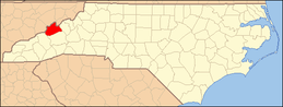 | |
| Unincorporated communities | ||
This article is issued from Wikipedia - version of the 4/7/2016. The text is available under the Creative Commons Attribution/Share Alike but additional terms may apply for the media files.