Barmouth Bridge
| Barmouth Bridge Pont Abermaw | |
|---|---|
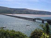 View of the bridge from Barmouth | |
| Coordinates | 52°42′50″N 4°02′20″W / 52.714°N 4.039°WCoordinates: 52°42′50″N 4°02′20″W / 52.714°N 4.039°W |
| Carries | Rail traffic, pedestrians |
| Crosses | Afon Mawddach |
| Locale | Gwynedd, Wales |
| Heritage status | Grade II* listed |
| Characteristics | |
| Total length | 699 metres (764 yd) |
| History | |
| Opened | 1867 |
 Barmouth Bridge Location within Wales | |
Barmouth Bridge (Welsh: Pont Abermaw), also known as Barmouth Viaduct, is a single-track largely wooden railway viaduct that carries the Cambrian Coast Railway across the River Mawddach estuary on the coast of Cardigan Bay, Wales. It sits between Morfa Mawddach and Barmouth in Gwynedd and caters for rail, foot and cycle traffic.
The bridge opened in 1867, and originally included a drawbridge section at its north end for tall ships to pass, though this was later replaced by the current swing bridge section. In 1980, woodworm threatened the safety of the bridge, which needed major repairs to avoid closure. Tolls were collected for foot and cycle traffic until 2013. The bridge is a Grade II* listed structure, and has one of the longest timber viaducts still in regular use in Britain.[1]
Location and structure

The bridge crosses the estuary of the River Mawddach from Morfa Mawddach near Arthog northwards to the edge of Barmouth.[2] The line is operated by Arriva Trains Wales, with connecting services south to Aberystwyth and east to Welshpool and Shrewsbury.[3] The section containing the bridge is on the Cambrian Coast railway between Machynlleth and Pwllheli.[4] The bridge is a Grade II* listed structure about 699 metres (764 yd) long[5][6] and contains 113 wooded trestles supported by a series of cast iron piers. It is one of the longest timber viaducts still standing in Britain.[5][7]
A footbridge is incorporated on the eastern side and pedestrians, cyclists and motorcycles can cross the estuary by the side of the track.[6] Since 1996, this has formed part of the National Cycle Route that links North and South Wales.[2] The footbridge is owned by Network Rail but an agreement is in place with Gwynedd County Council, who pay for 10% of the annual maintenance in exchange for a licence to use the bridge.[8]
Most of the bridge is built on a gravel bed covered by shifting sand. The north end by the swing bridge section is next to the rock of Figle Fawr at the base of Cadair Idris, and the river channel here can flow up to 9 knots (16.7 km/h). The first two spans here are built directly onto the rock.[5]
There is no nearby crossing for road traffic. The nearest spanning the Afon Mawddach is a toll bridge at Penmaenpool about 5 miles (8 km) further upstream and permits vehicles up to 2.5 tonnes. Heavier vehicles must use the first public road bridge, which is at Dolgellau about 10 miles (16 km) from Barmouth.[9]
History

The bridge was first proposed as part of the Cambrian Line between Aberystwyth and Pwllheli by the Aberystwyth and Welsh Coast Railway around 1861 - 2. It was designed by Benjamin Piercy and Henry Conybeare in 1864, and opened on 10 October 1867. Conybeare decided to construct the viaduct from timber as it would be cheaper to import by sea than iron.[5] As built, it included a wooden lifting drawbridge section at the northern end to permit the passage of tall ships. It was never in regular use since the opening of the railway killed off competition from boat traffic.[10] In 1899, the drawbridge arrangement was changed to the current swing bridge arrangement. It is still theoretically in operation, though it has not been opened since 1987 as part of a test operation.[5]
In 1946, the bridge was nearly destroyed after a live naval mine washed ashore close to the bridge during stormy weather. The mine briefly swept one of the pillars, but did not detonate.[11]
Passenger train services over the bridge declined significantly after the Ruabon to Barmouth line via Llangollen and Dolgellau was closed in 1965, causing all traffic to take the longer and slower route from Shrewsbury via Machynlleth and Dovey Junction. The old trackbed from Morfa Mawddach railway station to Dolgellau now forms the Mawddach Trail, a walk and cycle trail.[12]
By 1980 the bridge's structure had come under attack from marine woodworm, which threatened its closure.[13] British Rail discovered that woodworm had eaten into 69 of the supporting pillars and estimated it would cost £2.5 million to repair.[14] Locomotive-hauled trains were banned, which immediately resulted in the loss of traffic from Tywyn, including explosives traffic to and from the factory at Penrhyndeudraeth. That traffic was re-routed via Maentwrog Road railway station and the Conwy Valley Line.[15] However, Gwynedd County Council were opposed to closing the bridge completely as 40% of all railway traffic in the area was tourist related.[13] The government applied for a £2.5 million grant from the EEC to repair the bridge,[16] with a further £4.6m being spent on improving the signalling.[13] The bridge was closed entirely to traffic for six months during the temporary repair works eventually undertaken, and 30 of the piles were replaced.[14]

On 13 April 1986, a British Rail Class 37 37427 was named "Bont Y Bermo" to celebrate the (short-lived) re-introduction of locomotive-hauled trains following repairs in 1985–1986. Following major repairs the weight restriction was relaxed in 2005, and locomotive-hauled trains have again been allowed to cross.[17]
In March 2013, the Barmouth Viaduct Access Group (B-VAG), was established to investigate an alternative route from the town centre to the bridge, as the current walkway is steep, narrow, and unsuitable for buggies or wheelchairs.[18] In June, the toll was removed after the collectors left and were not replaced. The council have not yet decided how to pay for the bridge's maintenance costs, which were £39,405 for the year.[6] This has proved to be problematic as the revenue collected from tolls has not been sufficient to cover the council's share of costs, and there is not a sufficient budget to employ any full-time staff to collect payments.[8]
Gwynedd County Council has proposed closing the bridge to pedestrians and cyclists for cost reasons, as it needs to find £9 million worth of savings by April 2016. The potential closure of the bridge is one of over 100 cost saving options totalling £13 million to be put to a public consultation in Autumn 2015; the council currently pays Network Rail £30,800 per year towards maintenance costs. A petition calling on the council to "cease considerations of closing this much loved walking and cycling route" attracted 20,000 signatures within a week.[19][20] In February 2016, it was reported that the bridge would not close.[21]
See also
- List of bridges in Wales
- Pont Briwet, a former 19th-century timber viaduct built by the Aberystwith and Welsh Coast Railway.
References
Citations
- ↑ "Barmouth Railway Bridge,(Partly in Arthog Community) Barmouth Bridge, Barmouth Date Listed: 22 March 1988 Cadw Building ID: 5207". British Listed Buildings. Retrieved 10 April 2016.
- 1 2 Gwynedd County Council 2013, p. 1.
- ↑ "Cambrian Line". Arriva Trains Wales. Retrieved 6 October 2014.
- ↑ "Cambrian Coast Railway Line". Aberystwyth Town Council. Retrieved 6 October 2014.
- 1 2 3 4 5 "Barmouth Viaduct". Engineering Times. Retrieved 9 October 2014.
- 1 2 3 "Barmouth Bridge in Gwynedd toll-free as staff leave". BBC News. 11 June 2013. Retrieved 6 October 2014.
- ↑ Breverton, Terry (2012). Wales: A Historical Companion. Amberley Publishing Limited. p. 54. ISBN 978-1-4456-0990-4.
- 1 2 Gwynedd County Council 2013, p. 2.
- ↑ Green, Jim (2000). Holy Ways of Wales. Y Lolfa. p. 117. ISBN 978-0-86243-519-6.
- ↑ Hollingsworth, John Brian (1982). Atlas of the World's Railways. Bison. p. 72.
- ↑ "Barmouth Viaduct". Western Morning News. 23 April 1946. p. 2. Retrieved 8 November 2014 – via British Newspaper Archive. (subscription required (help)).
- ↑ "Mawddach Trail". Snowdonia National Park Authority. Archived from the original on 15 October 2014. Retrieved 9 October 2014.
- 1 2 3 Evan Evans, Lord Mountevans (26 February 1986). "Settle/Carlisle Railway: Proposed Closure". Retrieved 7 October 2014.
- 1 2 Pearce, Fred; Hamer, Mick (12 May 1983). "The Empire's Last Stand". New Scientist: 387. Retrieved 9 October 2014.
- ↑ Baughan, Peter (1991). North and Mid Wales, Volume 11 of Regional Railway History Series. David St. John Thomas. p. 246. ISBN 978-0-946537-59-4.
- ↑ "European Community Loans and Grants". Hansard. 30 June 1980. Retrieved 7 October 2014.
- ↑ "The Railway Magazine" (149). 2003: 57.
- ↑ "New harbour walkway planned for Barmouth". Cambrian News. 28 March 2013. Retrieved 9 October 2014.
- ↑ "20,000-name petition to keep Barmouth Bridge open to all". BBC News. 20 August 2015. Retrieved 21 August 2015.
- ↑ Devine, Darren (20 August 2015). "Fight to save Barmouth Bridge sees 20,000 sign petition within a week". Wales Online. Retrieved 21 August 2015.
- ↑ "Caernarfon and Barmouth bridges SAVED from the axe...". Daily post. 8 February 2016. Retrieved 1 June 2016.
Sources
- Report to Cabinet : Barmouth Bridge (PDF) (Report). Gwynedd County Council. 11 June 2013. Retrieved 27 October 2016.
External links
| Wikimedia Commons has media related to Barmouth Bridge. |