Barking Riverside
| Barking Riverside | |
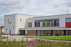 Rivergate Centre |
|
 Barking Riverside |
|
| OS grid reference | TQ466825 |
|---|---|
| – Charing Cross | 10.5 mi (16.9 km) W |
| London borough | Barking & Dagenham |
| Ceremonial county | Greater London |
| Region | London |
| Country | England |
| Sovereign state | United Kingdom |
| Post town | BARKING |
| Postcode district | IG11 |
| Dialling code | 020 |
| Police | Metropolitan |
| Fire | London |
| Ambulance | London |
| EU Parliament | London |
| UK Parliament | Barking |
| London Assembly | City and East |
Coordinates: 51°31′22″N 0°06′45″E / 51.5228°N 0.1124°E
Barking Riverside is a large area of redevelopment in East London, England. It is being built on land formerly occupied by Barking Power Station, adjacent to the River Thames. Purchased by Bellway Homes in 1994, the brownfield site has planning permission for 10,800 homes, of which only 1,200 can be built until improved public transport access is provided. The area was initially to be served by an extension of the Docklands Light Railway, but it was announced as part of the 2014 United Kingdom budget that the London Overground Gospel Oak to Barking Line would be extended to Barking Riverside to allow the development to be completed as planned.[1]
Between 1995 and 2000 Bellway built 900 homes and since 2004 the development has been managed by Barking Riverside Ltd, a partnership between GLA Land and Property and Bellway. Building work under this partnership commenced in 2010 and the first homes were occupied in 2012. There will be three neighbourhood centres and, when complete, the development as a whole will have a population of approximately 26,000.
History
The development is taking place on brownfield land that was formerly occupied by Barking Power Station. Prior to being drained for industrial use, it was tidal marshland. The power station closed in 1981, with a concentration of National Grid pylons, overhead lines, cables and sub stations remaining.
In the early 1990s, the Department of Environment sought brownfield sites in the Thames Gateway area for development. The Barking project started as a public-private venture between the Greater London Authority, English Partnerships and developer Bellway Homes.[1] National Power sold the land to Bellway Homes in 1994.[2] The site has low land value, but the cost of converting it from industrial use caused Bellway to be concerned about profitability. Initially Bellway constructed 900 homes on the site between 1995 and 2000, but these were criticised for poor design and for being cut off from services. Barking Riverside Ltd provided essential infrastructure such as roads, utilities and community facilities. Work started in 2010, and the first homes following the establishment of Barking Riverside Ltd were completed and occupied in 2012.[3]
The site is in the London Riverside section of the Thames Gateway and was within the area of the London Thames Gateway Development Corporation (LTGDC), established in 2004. The development corporation was abolished in 2013 and responsibility passed to GLA Land and Property (GLAP), a subsidiary of the Greater London Authority (GLA). The project was jointly managed by the Homes and Communities Agency until its London operations were folded into the GLA in April 2012.[4] In 2004 Barking Riverside Ltd was formed as a joint venture of Bellway Homes and the Homes and Communities Agency (later replaced by GLAP) to deliver the project. Outline planning permission was granted in August 2007, with detailed consent for the first phases given in June 2009.[5]
Toponymy
Barking is an ancient parish name, found in the Domesday Book of 1086. The appellation 'Barking Riverside' refers to the location adjacent to the River Thames. Initially the name Barking Reach was selected for the area.[2]
Governance
The local authority is Barking and Dagenham London Borough Council. The development is within the Thames ward, which returns three councillors. For elections to the London Assembly it is part of the City and East constituency. For elections to the UK Parliament it is within the Barking constituency.
As of 2015, the two roads giving access to the development are still privately owned by the developers.[1]
Geography
The 443 acres (1.79 km2) site has planning permission for 10,800 homes and is expected to have a population of approximately 26,000 people.[6][7] It is located between the A13 road and Barking–Rainham railway line to the north and the River Thames to the south.[8] It has 1.2 miles (1.9 km) of riverside frontage. The intention is to create three neighbourhood centres. To the north is the Thames View Estate and to the west is the settlement of Creekmouth. To the south of Barking Riverside and over the River Thames is the large housing development of Thamesmead.
Culture and community
The Rivergate Centre is a community centre that houses halls for hire, a cafe, the George Carey Primary School, the Rivergate Church and the Riverside School (secondary).[9]
As of 2015, the development is lacking in facilities such as a pub, youth club or doctor’s surgery.[1]
Transport
Barking Riverside is connected to Barking, Ilford and Dagenham Dock by the East London Transit bus rapid transit service EL1 and EL2. Planning regulations limit the number of homes to 1,200 until adequate public transport is provided.[10] Initially, a Docklands Light Railway extension to Dagenham Dock was proposed to serve the area. This project was cancelled in 2008 and revived in 2009, but is without funding.[11] It was announced as part of the 2014 United Kingdom budget that the Gospel Oak to Barking Line of the London Overground would be extended to Barking Riverside.[12]
On 14 July 2016, Transport for London published a notice in the Official Journal of the European Union inviting potential suppliers to pre-qualify for the construction of the extension and a new terminus station, which is expected to begin in February 2018.[13]
References
- 1 2 3 4 Tim Burrows (17 August 2015). "No cafe, no pub, no doctor in London's most isolated suburb". The Guardian. Retrieved 17 August 2015.
- 1 2 National Audit Office (2007). "The Thames Gateway: Laying the Foundations" (PDF). London: The Stationery Office. pp. 51–54. Archived (PDF) from the original on 2015-08-17. Retrieved 17 August 2015.
- ↑ Barking Riverside | Greater London Authority Archived 20 October 2013 at the Wayback Machine.
- ↑ London | Homes and Communities Agency (HCA)
- ↑ "Barking Riverside Ltd: Continuation of Support and Statutory Accounts" (PDF). Greater London Authority. Archived from the original (PDF) on 22 March 2014. Retrieved 12 June 2015.
- ↑ Our story | Barking Riverside Barking Riverside
- ↑ Barking Riverside Archived 12 November 2014 at the Wayback Machine.
- ↑ "Archived copy" (PDF). Archived from the original (PDF) on 7 September 2012. Retrieved 2014-03-21.
- ↑ https://web.archive.org/web/20140323104821/http://rivergatecentre.org.uk/who-is-at-the-centre/. Archived from the original on 23 March 2014. Retrieved 23 March 2014. Missing or empty
|title=(help) - ↑ Boris Johnson calls for creation of new 'garden suburb' in Barking and Dagenham - Transport - News - London Evening Standard
- ↑ "Mayor's Transport Strategy, Chapter five—transport proposals". Transport for London. Retrieved 21 October 2009.
- ↑ Mayhew, Freddy (19 March 2014). "Budget 2014: Commitment to Overground Extension to Barking Riverside Announced Alongside Funding for New Homes". Barking and Dagenham Post. Archant Community Media. Retrieved 12 June 2015.
- ↑ "Works - 242174-2016 - TED Tenders Electronic Daily". ted.europa.eu. Retrieved 2016-07-16.
External links
| Districts |  | |
|---|---|---|
| Attractions | ||
| Parks and open spaces | ||
| Constituencies |
| |
| Tube and rail stations | ||
| Other topics | ||