Barkhan District
| Barkhan بارکھان تحصیل | |
|---|---|
| District / Tehsil | |
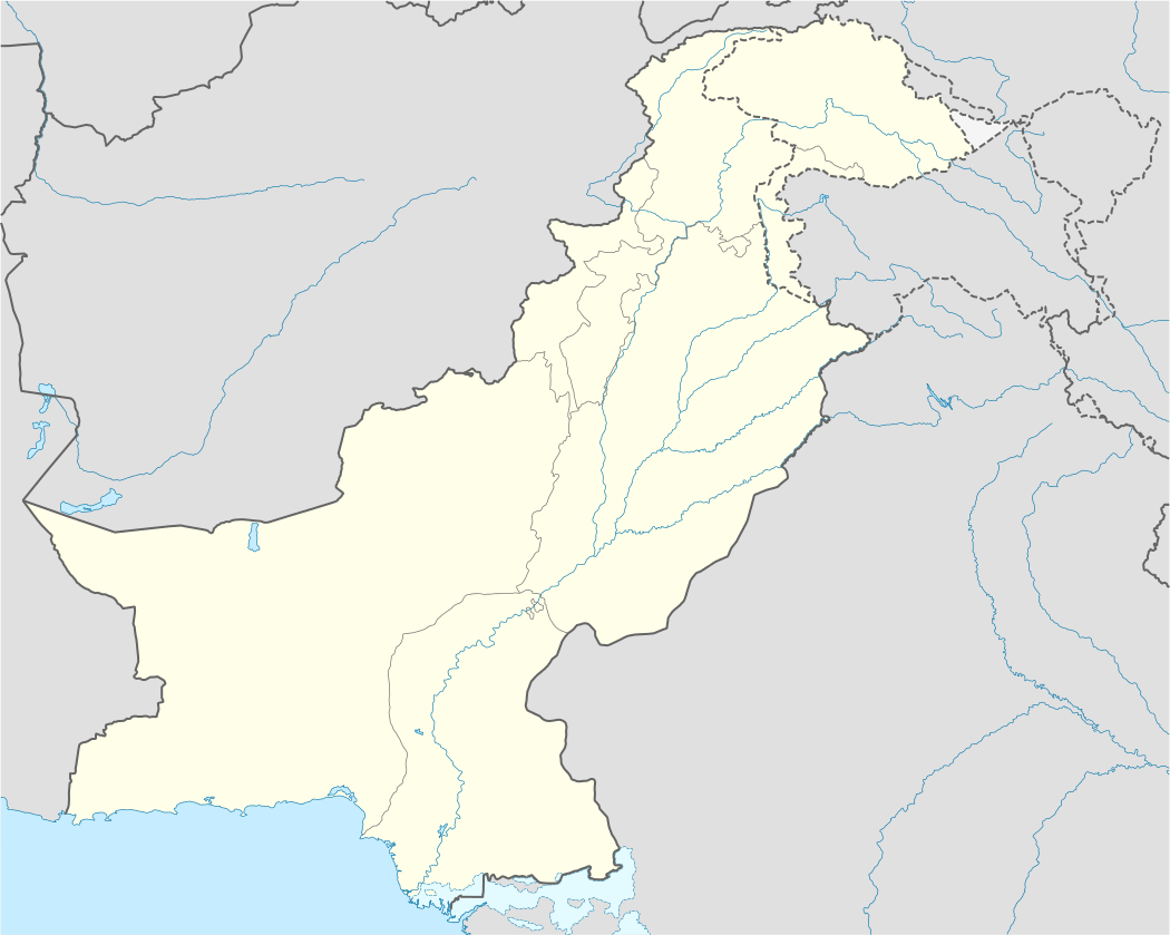 Barkhan Location in Pakistan | |
| Coordinates: 29°32′N 69°19′E / 29.54°N 69.31°ECoordinates: 29°32′N 69°19′E / 29.54°N 69.31°E | |
| Country |
|
| Province | Balochistan |
| District Status | 31st December, 1991 |
| Government | |
| • Type | Administrative |
| • MPA / Tribe Leader | Sardar Abdur Rehman Khetran[1] |
| • District Coordination Officer | Mehboob Shahwani |
| • Mayor[2] | Wadera Amir Muhammad |
| Area[3] | |
| • Total | 3,410 (Census 1,998) km2 (1,316 sq mi) |
| Elevation | 1,098 m (3,602 ft) |
| Population (Census 1998)[3] | |
| • Total | 103,545 |
| Barkhan Urban agglomeration | |
| Demonym(s) | Khetran |
| Time zone | PKT (UTC+5) |
| Postal code | 84400 |
| Dialling code | 0829[4] |
| Above Facts and Figures are stated with authentic citation, which are taken form Official Websites. | |
Barkhan (Urdu: بارکھان, ![]() pronunciation "Barkhan" was granted the status of separate district on 31 December 1991. The Eastern boundary of District Barkhan demarcates Punjab and Balochistan. Barkhan shares its boundaries in the east with district Dera Bugti while districts of Loralai and Kohlu are on the western side and Musakhail District is in the north. The district's headquarter is in “Barkhan” town.
pronunciation "Barkhan" was granted the status of separate district on 31 December 1991. The Eastern boundary of District Barkhan demarcates Punjab and Balochistan. Barkhan shares its boundaries in the east with district Dera Bugti while districts of Loralai and Kohlu are on the western side and Musakhail District is in the north. The district's headquarter is in “Barkhan” town.
Barkhan at Glance
| Particular | Facts |
|---|---|
| District Status | 31 December 1991 |
| Geographical Area | 3,410 Square kilometer (Census 1998) |
| Geographical Points | 69°3'-70° 4'East longitude and 29°37'-30°21'North latitude |
| Administrative Units | There are total 1 Tehsil and 8 Union Councils (LG Balochistan |
| Archaeological Sites | Fort of Mawand of Karam Khan Bijrani Marri, Dinosaur fossils |
| Shrine | Pir Shah Mehmood, BaBa Akhwand, Dada Jauund |
| Major Tribes | Khetran, Hasni, Syed, Marri |
| Languages | Major language is Khetrani Balochi |
History [5]
Early history of District Barkhan is obscure, however, it is said that this area remained under Muslim Rulers and conquerors of Kandahar and India. The Khetrans country was one of the sub-districts of Sewistan and of the Hind Province of Tatta. In Akbar's time it was called Janjah. Khetran is a Baloch tribe. " Mir Girazo Khan Mazarani Baloch" was first Sardar of the Khetrans. He was succeeded by his son "Bakhtiar Khan" and Bakhtiar Khan was succeeded by "Mir Haji Khan", whose rule is memorable among the Khetrans for a defeat which he inflicted on the Zhob Kakars. Mir Haji Khan was succeeded by a few nominal chiefs. Mir Haji Khan was a strong man and the Khetrans prospered under him. He also took revenge on the defeat of the Khetrans from Marris by destroying. The fort at "Mawand" of "Karam Khan Bijrani Marri". Haji Khan died leaving three sons: "Umar Khan", "Nawab Khan" and "Balu Khan". Yet he was succeeded by his brother "Sayed Khan", who was elected by the Khetrans. He too died, leaving three sons: "Dost Muhammad", "Sorni Khan" and "Kadir Bakhsh". Syed Khan was succeeded by his brother Balul Khan. Babul Khan was however opposed by Nawab Khan and Kadir Bakhsh. Kadir Bakhsh went to the Marris and gave his stepmother in marriage to Gazan, the Marri Chief and led Marris Lashkar against the Khetrans, who lost a lot of lives and property during the fights. Sir Rober Sandeman (then Deputy Commissioner, D.G. Khan), however, intervened and made peace between Kadir Bakhsh and Babul Khan
British Raj
Due to prolonged war among Khetrans, Lunis and Marris. In 1880, the Khetrans submitted a petition to the British authorities at D.G Khan, offering to pay revenue and to be taken under British protection. The Khetrans country remained under the political control of the British authorities of D.G Khan from 1878 to 1883. In 1883, Sardar Baloch Khan met Mr. Bruce, the Political Agent of Thaal Chotiali, with a Jirga of his tribesmen and the dispute between the Khetrans, Luni and Marris was settled. In 1884, the Khetrans came under the authority of the Agent to the Governor General in Balochistan. The Leghari Barkhan circle, comprising two valleys Barkhan and Vitakari, was transferred from Punjab control to Balochistan control in 1884. This district was brought under the direct administration of Balochistan in 1887, when work on the construction of D.G Khan - Pishin Road was started and a Tehsildar was posted at Barkhan. In 1889, Barkhan tehsil was transferred to the Zhob Agency with headquarters at Loralai. This tehsil however was transferred again to Thal Chotaili Agency in 1892. In October, 1903, the Thal Chotaili and Zhob Agencies were remodeled and three new agencies; Sibi, Loralai and Zhob were created and the Barkhan Tehsil was transferred to the Loralai Agency.
Geography
Area-wise district Barkhan is the 8th smallest district of Balochistan and has an area of 3,410 square kilometers, Barkhan District lies between 69°3'-70° 4'East longitude and 29°37'-30°21'North latitude consisting of 1 Tehsil and 8 Union Councils. Location of Barkhan is at 541 km (aerial distance) south-west (220 degrees bearing) of Pakistan's capital city Islamabad and 245 km east (97 degrees bearing) from Quetta City, the provincial capital of Balochistan.
Topography
Landscape of Barkhan consists of plains, valleys and mountains varying in ground elevation ranging from 841 to 2,031 meters above Mean Sea Level (MSL). The district consists of one main valley, called Barkhan, and several smaller valleys, which are separated from the main valley by low ranges of hills running in south-west direction. The Barkhan valley is enclosed on the north side by scattered low hills, which divide the drainage water of the valley from the waters flowing into the Rakhni stream in the south-west, and on the west and north-west side by the great Jandran range. The valley ends in the Vitakari valley. To the east of the Sukha range is the Kharcha valley, which is bounded by the Phulai range on the east. The hills in the district belong to the Suleman range; the principal hills are known as Kala Pahar in the north, Karwada, Bibar, Jandra and Mar or Mukhmar in the west, Andari and Sukha in the south, Phulai and Khawaj in the east, and Mazara, Tagha, Dig and Deka in the centre and Rakhni areas. The Ranges mostly consists of earth sand and stones; some portions are rocky and not easily accessible. The Jandran range is mostly rocky. In the south runs the Han stream with its tributaries. The Han stream runs in a south-west direction and carries the drainage of the Han pass and the south-eastern slopes of the Jandran range. At Dhamani (Barkhan Tehsil) the stream becomes perennial up to its junction with the Kah River in Dera Ghazi Khan district. Dhaula stream, its tributary, brings water from the hills situated to the south of the Bagha valley and irrigates a number of villages in the Barkhan valley and joins Han in Vitakari. Rakhni and Han join Kah Stream which then passes into the district of Dera Ghazi Khan.
A third important stream is Bala Dhaka. This stream lies in Berg-Sham Mauza of the Barkhan Tehsil. The stream is a tributary of the Narechi River (Duki Tehsil). Water in this stream comes down from the south-western slopes of hills located north of the Han pass. The stream irrigates a very small area of Mauza Berg-Sham, and then its water passes in the Duki Tehsil.
Archaeological Sites
During geological mapping and bio-stratigraphic research activity in Barkhan District, the geologists of the Geological Survey of Pakistan (GSP) discovered the first dinosaur fossils in Pakistan.[6][7]
Tribes and Language
There are three main tribes in Barkhan District: the Khetran, Marri and Buzdar. Main tribe of the area is Khetran. The Khetrans have a chief/ Tumandar of tribe, while, each sub-clan/section is represented by a headman called Wadera. Major language of Barkhan District is Khetrani Balochi.
Climate
Barkhan has a hot semi-arid climate (Köppen climate classification BSh) with very hot summers and mild winters. Precipitation mainly falls in two distinct periods: light to moderate rain in the late winter and early spring from February to April, and heavier rain in the monsoon from June to September.
| Climate data for Barkhan | |||||||||||||
|---|---|---|---|---|---|---|---|---|---|---|---|---|---|
| Month | Jan | Feb | Mar | Apr | May | Jun | Jul | Aug | Sep | Oct | Nov | Dec | Year |
| Record high °C (°F) | 25.0 (77) |
26.7 (80.1) |
33.0 (91.4) |
39.0 (102.2) |
42.8 (109) |
44.2 (111.6) |
42.3 (108.1) |
41.6 (106.9) |
40.8 (105.4) |
37.0 (98.6) |
32.2 (90) |
28.0 (82.4) |
44.2 (111.6) |
| Average high °C (°F) | 16.2 (61.2) |
17.5 (63.5) |
23.3 (73.9) |
30.0 (86) |
35.1 (95.2) |
37.8 (100) |
35.4 (95.7) |
34.4 (93.9) |
33.5 (92.3) |
29.9 (85.8) |
24.2 (75.6) |
18.9 (66) |
28.02 (82.43) |
| Daily mean °C (°F) | 10.1 (50.2) |
11.7 (53.1) |
17.1 (62.8) |
23.5 (74.3) |
28.6 (83.5) |
31.0 (87.8) |
29.5 (85.1) |
28.7 (83.7) |
27.0 (80.6) |
23.0 (73.4) |
17.3 (63.1) |
12.2 (54) |
21.64 (70.97) |
| Average low °C (°F) | 4.1 (39.4) |
6.4 (43.5) |
11.1 (52) |
17.1 (62.8) |
22.1 (71.8) |
24.4 (75.9) |
23.7 (74.7) |
23.1 (73.6) |
20.5 (68.9) |
15.9 (60.6) |
10.4 (50.7) |
5.6 (42.1) |
15.37 (59.67) |
| Record low °C (°F) | −1.7 (28.9) |
−2.2 (28) |
2.0 (35.6) |
6.1 (43) |
13.0 (55.4) |
13.0 (55.4) |
15.7 (60.3) |
16.7 (62.1) |
13.9 (57) |
9.0 (48.2) |
2.0 (35.6) |
−10 (14) |
−10 (14) |
| Average precipitation mm (inches) | 12.2 (0.48) |
21.7 (0.854) |
35.4 (1.394) |
32.3 (1.272) |
17.8 (0.701) |
35.3 (1.39) |
108.8 (4.283) |
95.5 (3.76) |
43.4 (1.709) |
3.6 (0.142) |
5.8 (0.228) |
6.8 (0.268) |
418.6 (16.481) |
| Source: NOAA (1971-1990) [8] | |||||||||||||
Government and politics
Barkhan started functioning as a district on 31 November 1991 and previously, it was a Tehsil of District Loralai. The main motive to grant Barkhan the status of a district was to provide basic facilities at the grass root level and to give easy access to people to the public offices. District Barkhan comprises only one Tehsil, Barkhan itself.
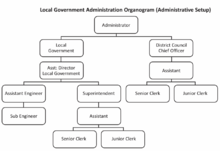
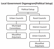
Balochistan Local Government Ordinance (BLGO) of 1980 was executed, which was meant to involve the local population in the development of their areas, was further replaced by BLGO 2001 with the concept of district Government. Under BLGO 2001, District Barkhan had 01 Tehsil and 8 Union Councils. The district was administrated from a single line of administration that covered both the rural as well as the urban areas. The system continued for two tenures and was again modified through the approval of BLGA 2010.The present system under the Local Government Act 2010 is similar to BLGO 1980 that emphasizes on rural-urban division but no elections were held under the latest system.
District Council

There are 8 Union Councils' representatives in District Council of Barkhan, one from each Union Council. Special seats are allocated to the representatives of workers/peasants, women and minorities as discussed in detail in the above paragraphs. All the elected chairmen of the Municipal Committees are also members of the District Council. The District Council is concerned with rural development activities and functions pertaining to, public health, education, agricultural development and economic welfare, articles of food and drink, drainage, livestock and dairy development, culture and public safety. The District Council can generate revenue by levying fees and various taxes as given in part II of second schedule of BLGA 2010.
Federal and Government Offices and Services
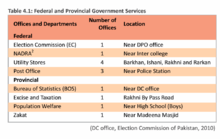
A number of Federal and Provincial Government departments are providing services at the district level. Except for FBS, Civil Defense and Passport & immigration, all other major departments are functional at the district level and some departments have got offices even at Tehsil level.(DC office, Election Commission of Pakistan, 2010)
Education and Educational institutions
The overall education condition is not satisfactory. Barkhan ranked at 124 in annul report of Alif Ailaan.[9] In case of rural females, only 6% had ever-attended any school and only 3% graduated from primary or higher levels. Primary Net Attendance Ratio of school-going age children was 39% with girls lower than boys (36% versus 41%). This indicates that 61% children were still out of school, which will either join late, or probably will never enroll. The total enrollment for middle classes up to December 2009 was 1,085 and total enrollment in secondary classes was only 595. One of the major reasons for low enrollment in secondary levels is non-availability of schools. Against 572 primary schools in the district, there are only 17 middle and 14 high schools. Primary school completion is relatively better (65%). There are 572 primary schools (407 male and 165 female), 17 middle schools (12 male and 5 female), 14 high schools (12 male and 2 female), 1 Girls Inter college and 1 Boys Degree 4 college.[10]
Flora and fauna
Mammals: Wolf, Hill Fox, Asiatic Jackal, Stripped Hyaena Cape Hare, Porcupine, Afghan Hedgehog, and Stone Marten . Birds: Chukar (Alectoris Chukar), See-see Partridge (Ammoperdix Griseogularis), Kestrel (Falco Tinnunculus), Golden Eagle (Aquila Chrysaetos Daphanea), a number of Finches, Buntings, Seasonal/migratory Waterfowls, Hawks, Bustards and Sand Grouse. Reptiles: Afghan Tortoise (Agrionemys Horsfieldii), Afghan Agama (Trapelus Megalonyx), Indian Cobra (Naja naja), Saw-scale Viper (Echis Carinatus), Dwarf Dark-headed Racer (Eirenis Persica Walteri) Levantine Viper (Macrovipera Lebetina), etc. Major Crops: Rabi crops: Wheat, Barley, Vegetable and Fodder. Kharif crops: Sorghum (Jowar), Millet (Bajra), Maize, Mung bean, Mash bean, Fruits, Onion, Potato, Vegetable, Melons, Chilies, Fodder, Garlic and Cotton. Major Fruit: Apricot, Peach, Grapes, Almond, Pomegranate, Apple, Plum
Natural Resources[11]
District Barkhan has deposits of coal and gypsum. Coal deposits are not large.. At some places, very minute quantities of coal were found but the work was abandoned as there was no prospect of commercial benefits. At present, a British oil exploration company[12] is conducted a survey and found oil reserves in Vitakari, Gadobra and some other areas.
References
- ↑ "Member Profile OF District Barkhan".
- ↑ "PPP secured the seat of district chairman Barkhan with Amir Mohammad Khetran as its candidate".
- 1 2 "District at a glance Barkhan". Government of Pakistan "Pakistan Bureau of Statistics".
- ↑ "National Dialing Codes". Pakistan Telecommunication Company Limited. Retrieved 28 August 2014.
- ↑ Dames, Mansel Longworth (March 2, 2012). The Baloch Race: A Historical And Ethnological Sketch. Nabu Press. ISBN 1276719884.
- ↑ Anwar, Ch. Muhammad (2000). Discovery of First Dinosaur Fossil in Pakistan, Barkhan District, Balochistan. Geological Survey of Pakistan. p. 17.
- ↑ Malkani, M. Sadiq (April 2006). "Biodiversity of Saurischian Dinosaurs from the Latest Cretaceous Park of Pakistan" (PDF). Journal of Applied and Emerging Science. 1 (3): 108-140.
- ↑ "Barkhan Climate Normals 1971-1990". National Oceanic and Atmospheric Administration. Retrieved January 17, 2013.
- ↑ Ailaan, Alif. "THE DISTRICT RANKINGS REPORTS FOR 2015". Alif Ailaan Education Report. 2015: 22,29,36,42.
- ↑ Balochistan Education, Department. "BEMIS". BEMIS. Balochistan Government. Archived from the original on 2013-08-16.
- ↑ Malkani, M. Sadiq; Shah, M. Raza (2014). "Chamalang coal resources and their depositional environments, Balochistan, Pakistan". Journal of Himalayan Earth Sciences. 47 (1): 61–72.
- ↑ BRITISH GAS, U.K COMPANY. "CLIENTAGE, 2". BIAFO.