Barköl Kazakh Autonomous County
| Barköl County 巴里坤县 • باركۆل ناھىيىسى • باركول اۋدانى (Chinese) • (Uyghur) • (Kazakh) | |
|---|---|
| Autonomous County | |
| Barköl Kazakh Autonomous County 巴里坤哈萨克自治县 باركۆل قازاق ئاپتونوم ناھىيىسى باركول قازاق اۆتونوميالى اۋدانى | |
.png) | |
| Country | China |
| Province | Xinjiang |
| Prefecture-level divisions | Hami Prefecture |
| Time zone | China Standard (UTC+8) |
Barköl Kazakh Autonomous County (Kazakh: Barköl Qazaq awtonomïyalıq awdanı, sometimes Barkul or Balikul in English) is part of Kumul Prefecture in Xinjiang, China and has an area of 38,445.3 square kilometres (14,843.8 sq mi). It forms part of the China–Mongolia border on the county's north, while bordering Hami City in the south and Changji's Mori Kazakh Autonomous County in the east.
Barköl was made an autonomous county on October 1, 1954. It is noted for camel and horse breeding with the Barköl horse well known throughout China. Due to the large number of camels, which is unparalleled in China, the county is nicknamed of the "county of ten thousand camels".
Ethnic groups in Barkol, 2000 census
| Barköl Kazakh Autonomous County | |||||||||
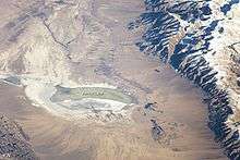 Barkol Lake and Barkol, astronaut photograph from ISS | |||||||||
| Chinese name | |||||||||
|---|---|---|---|---|---|---|---|---|---|
| Traditional Chinese | 巴里坤哈薩克自治縣 | ||||||||
| Simplified Chinese | 巴里坤哈萨克自治县 | ||||||||
| |||||||||
| Uyghur name | |||||||||
| Uyghur |
باركۆل قازاق
ئاپتونوم ناھىيىسى | ||||||||
| |||||||||
| Kazakh name | |||||||||
| Kazakh |
باركول قازاق اۆتونوميالى اۋدانى Баркөл Қазақ аутономиялық ауданы | ||||||||
| Ethnic group | Population | Percentage |
|---|---|---|
| Han | 55,169 | 64.18% |
| Kazakh | 29,236 | 34.01% |
| Mongol | 1,173 | 1.36% |
| Hui | 164 | 0.19% |
| Uyghur | 134 | 0.16% |
| Manchu | 26 | 0.03% |
| Tatar | 22 | 0.03% |
| Russian | 11 | 0.01% |
| Yi | 9 | 0.01% |
| Others | 20 | 0.02% |
Lake Barkol
Lake Barkol is an alkali lake in a closed basin located at 43°40′05″N 92°48′11″E / 43.668°N 92.803°E. Current rainfall averages 210 millimetres (8.3 in), while the annual evaporation rate is 2,250 millimetres (89 in). Ancient shorelines show up as concentric rings on the satellite photo at right, indicating that water levels have varied many times in the past. One study identified five climates at Lake Barkol over the past 8,000 years, ranging from warm and wet to cold and wet and finally cold and dry at present. The average annual temperature in the area is now just 1 °C (34 °F), though temperatures swing from extreme highs (33.5 °C (92.3 °F)) to extreme lows (−43.6 °C (−46.5 °F)).[1]
References
- ↑ Barkol Lake, Xinjiang at Nasa Earth Observatory
Coordinates: 43°36′N 93°01′E / 43.600°N 93.017°E