Barisal Division
| Barisal Division বরিশাল বিভাগ | ||
|---|---|---|
| Division of Bangladesh | ||
| ||
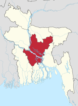
 Barisal Division in Bangladesh | ||
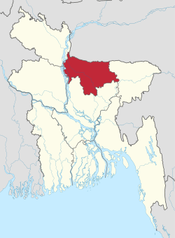
 Districts of Barisal Division | ||
| Coordinates: 22°30′N 90°20′E / 22.500°N 90.333°ECoordinates: 22°30′N 90°20′E / 22.500°N 90.333°E | ||
| Country |
| |
| Established | 1797 (as Backergunge District) | |
| Capital | Barisal city | |
| Government | ||
| • Commissioner | Mohammad Gaus | |
| Area | ||
| • Total | 13,225.20 km2 (5,106.28 sq mi) | |
| Elevation | 1.2 m (3.9 ft) | |
| Population (2011 census) | ||
| • Total | 8,325,666 | |
| • Density | 630/km2 (1,600/sq mi) | |
| Time zone | BST (UTC+6) | |
| ISO 3166 code | BD-A | |
| Districts | 6 | |
| Sub-Districts | 41 | |
| Union Councils | 352 | |
| Website |
barisaldiv | |
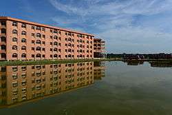
Barisal (Bengali: বরিশাল বিভাগ) is one of the eight administrative divisions of Bangladesh. Located in the south-central part of the country, it has an area of 13,644.85 km2 (5,268.31 sq mi), and a population of 8,147,000 at the 2011 Census (preliminary returns). It is bounded by Dhaka division on the north, the Bay of Bengal on the south, Chittagong division on the east and Khulna division on the west. The administrative capital, Barisal city, lies in the Ganges (Padma) River delta on an offshoot of the Arial Khan River (Kirtonkhola). Barisal division is criss-crossed by numerous rivers that earned it the nickname 'Dhan-Nodi-Kaal, Ei tine Barisal' (rice, river and canal built Barisal).
History
Early Middle Ages
In early times the Barisal region was composed of an amalgamation of marshlands formed by the merging of islands brought into existence and built up by alluvial soils washed down the great channels of the combined Brahmaputra-Ganges-Meghna river systems.
In the early 13th century, when Muhammad bin Tughluq completely conquered eastern Bengal, Hindu chieftains from northwest Bengal were dislodged from power and they dispersed over Barisal region and founded the kingdom of Bakla.
During the Mughal conquest in Bengal, Hindu society was concentrated to northern and western Barisal (known as Bakarganj). Barisal's southern portion was still covered by forests and laced with lagoons. The northwest was also the only part of Bakarganj where the Hindu population exceeded Muslims in early British censuses.
Mughal period
Barisal saw a second wave of immigration in the late 17th and early 18th centuries . This time, it was Muslim pioneers who assumed the leading role. Establishing Dhaka as the provincial Mughal capital of the region, in the early 17th century the Barisal region (known as Sarkar Bakla to Mughals) was more accessible to businessmen and developers than at any previous time. However, piracy in this region along the coasts and rivers of southeastern Bengal by Arakanese and renegade Portuguese seamen inhibited any sustained attempts by Mughal governors to push into the Barisal forests.
After 1666, when Mughal naval forces cleared the Meghna estuary of such external threats, the Barisal interior lay ripe for colonization. Land developers acquired grants of plots of land, taluq (তালুক), from provincial authorities. Abundant and easily obtainable by purchase from the late 17th century these grants tended to be regarded by their possessors taluqdar (তালুকদার). As taluqdars brought their taluqs into agricultural production, these men passed up the land revenue through a class of non-cultivating intermediaries, or zamindar (জমিদার). Zamindars typically resided in the provincial capital, where they had ready access to the chief provincial revenue officer, or dewan (দেওয়ান).
In a second pattern of land development, Muslim pirs or Qazi went directly into uncultivated regions, organized the local population for clearing the jungles, and only later, after having established themselves as local men of influence, entered into relations with the Mughal authorities. Relationships between the religious Muslim pirs and Mughal authorities was not always harmonious, since a pir’s natural ties of authority and patronage generally lay with the masses of peasants beneath him and not with the governors and bureaucrats. For example, in remote Jhalakati Thana in the eastern Bakarganj, an 18th-century pir named Saiyid Faqir wielded enormous influence with the cultivators of the all-Muslim village of Saiyidpur, named after the pir. But a difficulty arose, noted a 1906 village survey, because “the people of this part looked upon the Fakir as their guide and did not pay rent to the Nawab.” In this situation, one Lala Chet Singh, a captain in the employ of the governor, “succeeded in persuading the Fakir to leave the country.”
British rule
In 1797 the area was established as Bakerganj District but later renamed as Barisal District. The district was upgraded into
Bangladesh
The Greater Barisal region (Barisal District along with five other neighbouring districts) was created as Barisal Division on 1 January 1993.[1]
Economy
Barisal was once known as the "Granary of Bengal" for its rich production. It is still an important rice producing area of the country. Since the Middle Ages, Barisal has acted as a trans-shipment center for hides, rice, dried beans, dried peas, lentils, chickpeas, and other pulses for Bengal. Bakery, textile, and pharmaceutical products are the output of a few industrial installations. There is a medical college (Sher-e Bangla Medical College) affiliated with the National University. The most famous education institution of Barisal Division is B. M. College (established in 1889). Barisal is also a river port once connecting Calcutta-Barisal-Dhaka and many other routes. Today Barisal River port is the most important hub of steamer and motor launch service of the Southern Bangladesh.
Points of interest

Kuakata beach is the main tourist spot in the division. It is one of the two sea beaches in South Asia where both sunrise and sunset at sea can be seen.
Durga Sagor is another beautiful Dighi where a number of migratory birds arrive every winter. There are 42 upazilas in total in Barisal division: most recent upazilas are Rangabali in Patuakhali and Taltoli in Barguna.
Administration
The division is subdivided into six districts (zilas) and thence into 39 sub-districts (upazilas). Lower level administrative areas are 353 union parishads, 3,159 mouzas, 12 municipalities, 25 wards and 4,163 villages.
| Name | Capital | Area (km²) | Population 1991 Census | Population 2001 Census | Population 2011 Census |
|---|---|---|---|---|---|
| Barisal District | Barisal | 2,784.52 | 2,207,426 | 2,355,967 | 2,324,310 |
| Barguna District | Barguna | 1,831.31 | 775,693 | 848,554 | 892,781 |
| Bhola District | Bhola | 3,403.48 | 1,476,328 | 1,703,117 | 1,776,795 |
| Jhalokati District | Jhalokati | 706.76 | 666,139 | 694,231 | 682,669 |
| Patuakhali District | Patuakhali | 3,221.31 | 1,273,872 | 1,460,781 | 1,535,854 |
| Pirojpur District | Pirojpur | 1,277.80 | 1,063,185 | 1,111,068 | 1,113,257 |
| Total Division | Barisal | 13,255.20 | 7,462,643 | 8,173,718 | 8,325,666 |
Transport
Numerous rivers and canals force the inhabitants to use boats as the main medium of transportation. The main rivers are the Arial Khan, Bishkhali, Burishwar, Tentulia, Paira, Haringhata, Baleshwar, Kirtankhola, Katcha, and Agunmukha. It is linked by steamer with Dhaka (73 miles [117 km] to the north) and with Chittagong to the southeast. Road communication has improved significantly over last decades with the building of many bridges. The Barisal airport has regular service to Dhaka.
Education
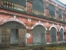
Barisal division has one of the highest literacy rates of the country, just behind Dhaka division. One of the country's oldest educational institutions, Brojomohun College was established in 1889. The division contains Sher e Bangla Medical College and one science and technological university. Recently the government has passed a bill approving the building of the new Barisal University.
- Universities
- Government colleges
Total thirteen government colleges:
Most notable:
- Brojomohun College
- Bhola Govt. College
- Government Syed Hatem Ali College
- Bhandaria Government College
- Barisal Government Women’s College
- Govt. Fazlul Haque College, Chakhar
- Govt. Fazilatunnessa Women’s College, Bhola
- Private colleges
Eighteen private colleges:
- Barisal Institute of Information Technology
- Infra Polytechnic Institute
- Dr. Arifur Rahman Commerce College
- Ideal Polytechnic Institute
- Shah Mahmudia College
- Medical college

- Engineering Colleges
Shahid Abdur Rab Serniabat Textile Engineering College, Barisal
- Government high schools
There are nineteen government high schools. Among them Barisal Zilla School, Bhola Govt. High School and Pirojpur Govt. High School (are A Grade School during the British Raj) and Barisal Sadar Girls School are three most famous schools of the Barisal Division.
- Private high schools
852 Private high schools
- Polytechnic institutes
Four polytechnic institute:
- Barguna Polytechnic Institute
- Barisal Polytechnic Institute
- Bhola Polytechnic Institute
- INFRA Polytechnic Institute[2]
- Patuakhali Polytechnic Institute
- ABC Polytechnic Institute
- Junior high schools
180 junior high schools
- Private school
Ideal Cadet School and College Udayan High School, Barisal.
- Law colleges
3 law colleges
- Cadet colleges
1 cadet college: Barisal Cadet College
- Teachers' Training Colleges
4 teachers' training colleges
- Madrasas
1616 madrasas: Sagordi Islamia Kamil Madrash under the Islamic University Kustia, Jhalokati N S Kamil Madrasah
- Primary schools
- Government: 2,583
- Non-government: 1,982
Religion
The religions in Barisal Division include Islam, Hinduism, Christianity, Buddhism, and others.
Notable residents
- A.K. Fazlul Huq, an eminent nationalist, politician
- Abdul Gaffar Choudhury, an author, columnist, lyricist.
- Altaf Mahmud noted Bengali film song composer.
- Major M. A. Jalil, the commander of the Sector 9 during Bangladesh War of Liberation in 1971.
- Mohiuddin Jahangir (Bir Shreshto), a freedom fighter
- Abala Bose, social reformer and wife of Jagadish Chandra Bose
- Shaheed Abdur Rob Serniabat, Bengali Potitician
- Kusumkumari Das, poet and mother of Jibanananda Das
- Jibanananda Das, famous poet.
- Abu Zafar Obaidullah, poet
- Sufia Kamal, poet
- Mihir Sengupta, Writer
- Aswini Kumar Dutta, social reformer and philanthropist
- Aroj Ali Matubbar, noted astronomer and philosopher.
- Abdur Rahman Biswas, Former President of Bangladesh
- Amal Kumar Raychaudhuri, physicist
- Anil Biswas (composer) noted Hindi and Bengali film song composer
- Kamini Roy, famous poet and first woman graduate with honours in the subcontinent.
- Kadambini Ganguly, first female physician in the entire British empire
- Hanif Sanket, Famous TV presenter, entertainer, writer and producer.
- Mosharraf Karim, actor
- Mir Sabbir, actor
- Tania Ahmed, actress
- Golam Mustafa, film actor
- Suborna Mustafa, actress
- Mithun Chakraborty, film actor.
- Pannalal Ghosh renowned musician and flutist
- Partha Dasgupta, eminent economist.
- Parul Ghosh, Hindi and Bengali film singer
- Priya Ranjan Dasmunsi, Minister of parliamentary affairs and information, India.
- Salman Khan, Founder of Khan Academy
- Sohag Gazi, cricketer
- Tapan Raychaudhuri, noted historian.
- Tofazzal Hossain Manik Miah Founder Editor of The Daily Ittefaq.
- Utpal Dutt (1929 – 1993), an Indian actor, director and writer-playwright.
- Manabendra Mukhopadhyay, Music composer & a famous singer of Nazrul geeti
References
- ↑ "The Rise of Islam and the Bengal Frontier, 1204–1760". Escholarship.org. Retrieved 2013-02-15.
- ↑ "infra.edu.bd". infra.edu.bd. Retrieved 2013-02-15.
Sources
Census figures for 1991, 2001 and 2011 are from Bangladesh Bureau of Statistics, Population Census Wing. The 2011 Census figures are based on preliminary results.
External links
| Wikivoyage has a travel guide for Barisal Division. |
| Wikimedia Commons has media related to Barisal Division. |
 |
Dhaka Division | | ||
| Khulna Division | |
Chittagong Division | ||
| ||||
| | ||||
| Bay of Bengal |
| Barisal Division |  | |
|---|---|---|
| Chittagong Division | ||
| Dhaka Division | ||
| Khulna Division | ||
| Mymensingh Division | ||
| Rajshahi Division | ||
| Rangpur Division | ||
| Sylhet Division | ||