Barguzinsky District
| Barguzinsky District Баргузинский район (Russian) Баргажанай аймаг (Buryat) | |
|---|---|
.svg.png) Location of Barguzinsky District in the Buryat Republic | |
| Coordinates: 53°37′N 109°37′E / 53.617°N 109.617°ECoordinates: 53°37′N 109°37′E / 53.617°N 109.617°E | |
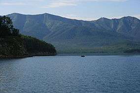 Zmeinaya Bay in Barguzinsky District | |
 |
.png) |
|
| |
| Location | |
| Country | Russia |
| Federal subject | Republic of Buryatia[1] |
| Administrative structure (as of July 2013) | |
| Administrative center | selo of Barguzin[1] |
| Administrative divisions:[1] | |
| Urban-type settlements | 1 |
| Selsoviets | 6 |
| Somons | 3 |
| Inhabited localities:[1] | |
| Urban-type settlements[2] | 1 |
| Rural localities | 33 |
| Municipal structure (as of October 2014) | |
| Municipally incorporated as | Barguzinsky Municipal District[3] |
| Municipal divisions:[3] | |
| Urban settlements | 1 |
| Rural settlements | 9 |
| Statistics | |
| Area | 18,553 km2 (7,163 sq mi)[4] |
| Population (2010 Census) | 23,598 inhabitants[5] |
| • Urban | 30.4% |
| • Rural | 69.6% |
| Density | 1.27/km2 (3.3/sq mi)[6] |
| Time zone | IRKT (UTC+08:00)[7] |
| Established | December 23, 1923[8][4] |
| Official website | |
| Barguzinsky District on WikiCommons | |
| 2010 Census | 23,598[5] |
|---|---|
| 2002 Census | 26,256[9] |
| 1989 Census | 27,585[10] |
| 1979 Census | 27,164[11] |
Barguzinsky District (Russian: Баргузи́нский райо́н; Buryat: Баргажанай аймаг) is an administrative[1] and municipal[3] district (raion), one of the twenty-one in the Republic of Buryatia, Russia. It is located in the northeast of the republic. The area of the district is 18,553 square kilometers (7,163 sq mi).[4] Its administrative center is the rural locality (a selo) of Barguzin.[1] As of the 2010 Census, the total population of the district was 23,598, with the population of Barguzin accounting for 24.2% of that number.[5]
Geography
The district is situated at the mouth of the Barguzin River within the Barguzin Valley. The absolute height of the bottom of the basin ranges from 500 to 700 meters (1,600 to 2,300 ft), whereas the elevation of the surrounding mountain ranges up to 2,000–2,700 meters (6,600–8,900 ft) above sea level.
In floodplain areas and terraces, the Barguzin River and its tributaries are characterized by the alternation of a mosaic of meadow steppe, steppe, and wetland spaces. Forest vegetation prevails in the foothill areas and on the slopes of the rivers, up to 1,100–1,300 meters (3,600–4,300 ft) altitude. The forests are rich in berries, mushrooms, and nuts.
History
The district was established on December 23, 1923.[8][4]
Administrative and municipal status
Within the framework of administrative divisions, Barguzinsky District is one of the twenty-one in the Republic of Buryatia.[1] It is divided into one urban-type settlement (an administrative division with the administrative center in the urban-type settlement (an inhabited locality) of Ust-Barguzin), six selsoviets, and three somons, which comprise thirty-three rural localities.[1] As a municipal division, the district is incorporated as Barguzinsky Municipal District.[3] The urban-type settlement is incorporated as an urban settlement, and the six selsoviets and three somons are incorporated as nine rural settlements within the municipal district.[3] The selo of Barguzin serves as the administrative center of both the administrative[1] and municipal[3] district.
References
Notes
- 1 2 3 4 5 6 7 8 9 Resolution #431
- ↑ The count of urban-type settlements may include the work settlements, the resort settlements, the suburban (dacha) settlements, as well as urban-type settlements proper.
- 1 2 3 4 5 6 Law #985-III
- 1 2 3 4 Official website of the Buryat Republic. Information about Barguzinsky District (Russian)
- 1 2 3 Russian Federal State Statistics Service (2011). "Всероссийская перепись населения 2010 года. Том 1" [2010 All-Russian Population Census, vol. 1]. Всероссийская перепись населения 2010 года (2010 All-Russia Population Census) (in Russian). Federal State Statistics Service. Retrieved June 29, 2012.
- ↑ The value of density was calculated automatically by dividing the 2010 Census population by the area specified in the infobox. Please note that this value is only approximate as the area specified in the infobox does not necessarily correspond to the area of the entity proper or is reported for the same year as the population.
- ↑ Правительство Российской Федерации. Федеральный закон №107-ФЗ от 3 июня 2011 г. «Об исчислении времени», в ред. Федерального закона №271-ФЗ от 03 июля 2016 г. «О внесении изменений в Федеральный закон "Об исчислении времени"». Вступил в силу по истечении шестидесяти дней после дня официального опубликования (6 августа 2011 г.). Опубликован: "Российская газета", №120, 6 июня 2011 г. (Government of the Russian Federation. Federal Law #107-FZ of June 31, 2011 On Calculating Time, as amended by the Federal Law #271-FZ of July 03, 2016 On Amending Federal Law "On Calculating Time". Effective as of after sixty days following the day of the official publication.).
- 1 2 Official website of Barguzinsky District (Russian)
- ↑ Russian Federal State Statistics Service (May 21, 2004). "Численность населения России, субъектов Российской Федерации в составе федеральных округов, районов, городских поселений, сельских населённых пунктов – районных центров и сельских населённых пунктов с населением 3 тысячи и более человек" [Population of Russia, Its Federal Districts, Federal Subjects, Districts, Urban Localities, Rural Localities—Administrative Centers, and Rural Localities with Population of Over 3,000] (XLS). Всероссийская перепись населения 2002 года [All-Russia Population Census of 2002] (in Russian). Retrieved August 9, 2014.
- ↑ Demoscope Weekly (1989). "Всесоюзная перепись населения 1989 г. Численность наличного населения союзных и автономных республик, автономных областей и округов, краёв, областей, районов, городских поселений и сёл-райцентров" [All Union Population Census of 1989: Present Population of Union and Autonomous Republics, Autonomous Oblasts and Okrugs, Krais, Oblasts, Districts, Urban Settlements, and Villages Serving as District Administrative Centers]. Всесоюзная перепись населения 1989 года [All-Union Population Census of 1989] (in Russian). Институт демографии Национального исследовательского университета: Высшая школа экономики [Institute of Demography at the National Research University: Higher School of Economics]. Retrieved August 9, 2014.
- ↑ "Всесоюзная перепись населения 1979 г. Национальный состав населения по регионам России. (All Union Population Census of 1979. Ethnic composition of the population by regions of Russia.)". Всесоюзная перепись населения 1979 года (All-Union Population Census of 1979) (in Russian). Demoscope Weekly (website of the Institute of Demographics of the State University—Higher School of Economics. 1979. Retrieved 2008-11-25.
Sources
- Правительство Республики Бурятия. Постановление №431 от 18 ноября 2009 г. «О реестре административно-территориальных единиц и населённых пунктов Республики Бурятия», в ред. Постановления №573 от 13 ноября 2015 г. «О внесении изменений в Постановление Правительства Республики Бурятия от 18.11.2009 №431 "О реестре административно-территориальных единиц и населённых пунктов Республики Бурятия"». Вступил в силу 18 ноября 2009 г. Опубликован: "Бурятия", №216, Официальный вестник №120, 21 ноября 2009 г. (Government of the Republic of Buryatia. Resolution #431 of November 18, 2009 On the Registry of the Administrative-Territorial Units and the Inhabited Localities of the Republic of Buryatia, as amended by the Resolution #573 of November 13, 2015 On Amending Resolution #431 of November 18, 2009 of the Government of the Republic of Buryatia "On the Registry of the Administrative-Territorial Units and the Inhabited Localities of the Republic of Buryatia". Effective as of November 18, 2009.).
- Народный Хурал Республики Бурятия. Закон №985-III от 31 декабря 2004 г. «Об установлении границ, образовании и наделении статусом муниципальных образований в Республике Бурятия», в ред. Закона №1411-V от 14 октября 2015 г. «О внесении изменений в Закон Республики Бурятия "Об установлении границ, образовании и наделении статусом муниципальных образований в Республике Бурятия"». Вступил в силу со дня официального опубликования. Опубликован: "Бурятия", №1, Официальный вестник №1, 12 января 2005 г. (People's Khural of the Republic of Buryatia. Law #985-III of December 31, 2004 On Establishing the Borders, Creating, and Granting a Status to the Municipal Formations in the Republic of Buryatia, as amended by the Law #1411-V of October 14, 2015 On Amending the Law of the Republic of Buryatia "On Establishing the Borders, Creating, and Granting a Status to the Municipal Formations in the Republic of Buryatia". Effective as of the day of the official publication.).
Capital: Ulan-Ude | |||
| Districts | |||
| Cities and towns (all levels) | |||
| Urban-type settlements | |||