Bardon, Queensland
| Bardon Brisbane, Queensland | |||||||||||||
|---|---|---|---|---|---|---|---|---|---|---|---|---|---|
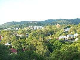 Looking southwest over Bardon at sunrise towards Mount Coot-tha | |||||||||||||
| Population | 9,256 (2011 census)[1] | ||||||||||||
| • Density | 1,653/km2 (4,280/sq mi) | ||||||||||||
| Postcode(s) | 4065 | ||||||||||||
| Area | 5.6 km2 (2.2 sq mi) | ||||||||||||
| LGA(s) |
City of Brisbane (The Gap Ward; Toowong Ward) | ||||||||||||
| State electorate(s) | Mount Coot-tha | ||||||||||||
| Federal Division(s) | Brisbane, Ryan | ||||||||||||
| |||||||||||||
Bardon is an inner suburb of the City of Brisbane, Queensland, Australia.[2] It is located approximately 5 kilometres (3.1 mi) west of the Brisbane CBD. Bardon is a leafy residential suburb, much of which nestles into the foothills of Mount Coot-tha.
History
The suburb of Bardon was originally known as 'Upper Paddington', until it was defined then renamed by the Ithaca Town Council in 1925[3][4] after 'Bardon', the villa built by Joshua Jeays in 1863 and named for Bardon Hill in his native Leicestershire, England.[2] The house now forms part of the campus of St Joseph's Catholic Primary School, The Drive, Bardon.[5]
Rainworth locality amalgamation into the suburb of Bardon
Originally there was a house with large lands on Boundary Street, Rosalie (now Toowong), called "Rainworth" owned by Sir Augustus Charles Gregory, Qld Surveyor-General; it was named after the town of Rainworth near his birthplace in Nottinghamshire, England. [source] After his death in 1905, the house and land were sold. [source] In the 1918 and 1925 the land was sold off for housing; see the 1925 land sale. The Rainworth Estate comprises land between Boundary Road and Rainworth Road south to Birdwood Street (formerly Heussler Terrace) and includes the streets of Barton Street, Dudley Street, Nestor Street (now gone), Osman Street (then Margaret Street), Rouen Road, Runic Street, and Vimy Street. The name persists through a school and local businesses. Although to this day, this locality name seems to be in such common use that they may not be lost at all, as many residents still associate their residence locations with this former locality name.[6]
The suburb is characterised by stand-alone houses on separate lots, which make up 89% of the housing stock in Bardon.[1]
Bardon is located in the foothills on the eastern side of Mount Coot-tha, and is characterised by ridges separated by steep gullies. Some major streets generally follow the ridgelines, including Simpsons Road and Macgregor Terrace. The side streets connecting to these ridge-line roads are among Brisbane's steepest. Ithaca Creek, a tributary of Enoggera Creek, drains the eastern side of Mount Coot-tha and flows through the suburb in a generally north-easterly direction.
Heritage listings
Bardon has a number of heritage-listed sites, including:
- 7 Barton Street: Rainworth House, the home of the explorer and statesman Augustus Charles Gregory[7]
- 41 The Drive: Bardon House, the home intended for Joshua Jeays, mayor and contractor[8]
- 100 Simpsons Road: Oogarding[9]
Demographics
In the 2011 census, Bardon recorded a population of 9,256 people, 52.8% female and 47.2% male.
The median age of the Bardon population is 36 years of age, 1 year below the Australian median.
79.7% of people living in Bardon were born in Australia, compared to the national average of 69.8%; the next most common countries of birth were England 4.5%, New Zealand 2.6%, United States of America 0.9%, South Africa 0.8%, Scotland 0.7%.
90.7% of people spoke only English at home; the next most popular languages were 0.8% Italian, 0.6% German, 0.6% French, 0.5% Spanish, 0.4% Dutch.
Facilities
Adjoining Bardon is Fernberg which serves as Government House, Queensland, the official residence of the Governor of Queensland in the suburb of Paddington.[10]
The suburb is home to the Wests Panthers rugby league club, Wests Juniors Leagues Club (a rugby league club) and Brisbane Irish Rugby Football Club. These sports teams are located in Purtell Park where home matches are played. Club facilities are undergoing refurbishment as of 2007. In 2012 Voices of Birralee moved their headquarters to Purtell Park and have set up a vibrant community arts hub. There are now 400 children and young people who rehearse there weekly.
Bowman Park in Bardon is home to the Bardon Latrobe (soccer) football club, one of the oldest football clubs in Brisbane, and the West Brisbane Cricket Club. The park, formerly known as the 'Cobbler's Flats', was named after prominent Queensland Labor politician, David Bowman (1860-1916),[11] as were the adjacent David Avenue[12] and Bowman Parade.[13]
Local schools include St Joseph's Catholic primary school, Bardon State School on Simpsons Rd, Rainworth State School on Boundary Road and Ithaca Creek State School on Lugg Street.
A small neighbourhood convenience shopping centre and various other shops and restaurants are located in and around Macgregor Terrace.
Transport
Bardon is well served by several Brisbane Transport bus services, including the 385 BUZ service, the cross-town Great Circle Line [Route 598/599],as well as several all-stops services to the city [Route 375-Bardon/City/Stafford City/City/Bardon].
%2C_circa_1929.JPG)
Prior to 1968, Bardon was serviced by a tram line which terminated at Morgan Terrace [Route 75]. The bus route has been extended from Morgan Terrace, past the Bardon State School, to terminate at Carwoola Street approximately 1.5 kilometres (0.93 mi) further out towards Mount Coot-tha.
Bardon is located on Metroad 5, a major north/south arterial that serves as a western bypass of Brisbane. Metroad 5 is known (from north to south) as Jubilee Terrace, Macgregor Terrace, an expressway-grade Boundary Road (1990s) and Rouen Road through the suburb.
Three major roads from the west and north converge on Macgregor Terrace, in addition to two major roads from the east and south, resulting in traffic congestion in peak periods. The Queensland Department of Main Roads investigated options for upgrading Macgregor Terrace and Jubilee Terrace in 2008, but in 2011 funding for the proposed upgrades were cut. [14]
References
- 1 2 Australian Bureau of Statistics (31 October 2012). "Bardon (State Suburb)". 2011 Census QuickStats. Retrieved 23 July 2008.
- 1 2 "Bardon (entry 47846)". Queensland Place Names. Queensland Government. Retrieved 28 March 2014.
- ↑ Brisbane Courier 30 September 1925
- ↑ Brisbane Courier 1 October 1925
- ↑ "Bardon House". The State of Queensland (Environmental Protection Agency). 2008. Archived from the original on 20 August 2008. Retrieved 25 July 2008.
- ↑ "Towns, suburbs & localities". Renamed Places in Queensland. Kerry Raymond.
- ↑ "Rainworth (entry 600282)". Queensland Heritage Register. Queensland Heritage Council. Retrieved 19 June 2013.
- ↑ "Bardon House (entry 600053)". Queensland Heritage Register. Queensland Heritage Council. Retrieved 19 June 2013.
- ↑ "Oogarding (entry 602074)". Queensland Heritage Register. Queensland Heritage Council. Retrieved 19 June 2013.
- ↑ The Office of the Governor, Queensland. "Gov House - Contact Us". Archived from the original on 23 March 2009. Retrieved 15 January 2009.
- ↑ Australian Dictionary of Biography
- ↑ Brisbane UBD
- ↑ Streets of Brisbane
- ↑ http://www.couriermail.com.au/questnews/west/no-joy-for-bardon-motorists-as-intersection-funds-run-out/story-fn8m0u4y-1226176051558?nk=1439e0060d0e02f8b0c20817b80c51ee-1453523657
External links
| Wikimedia Commons has media related to Bardon, Queensland. |
- University of Queensland: Queensland Places: Bardon
- "Bardon". BRISbites. Brisbane City Council. Archived from the original on 19 July 2008.
- "Bardon". Our Brisbane. Brisbane City Council. Archived from the original on 12 February 2008.
Coordinates: 27°27′40″S 152°58′29″E / 27.4612°S 152.9748°E