Barangka
| Barangay Barangka | |
|---|---|
| Barangay | |
 Barangay Barangka | |
| Coordinates: 14°37′47″N 121°4′49″E / 14.62972°N 121.08028°ECoordinates: 14°37′47″N 121°4′49″E / 14.62972°N 121.08028°E | |
| Country | Philippines |
| Region | National Capital Region |
| City | Marikina |
| District | 2nd Legislative district of Marikina |
| Government | |
| • Type | Barangay |
| • Barangay Captain | Efren Managuit |
| Population (2012) | |
| • Total | 29,776 |
| Time zone | PST (UTC+8) |
| Postal Code | 1803 |
| Area code(s) | 02 |
Barangka is one of sixteen barangays in Marikina, Philippines and one of the barangays in 1st District of Marikina. It is also one of the oldest barangay founded in Marikina.
Barangka is the main passageway between Quezon City and Marikina, and a gateway between Quezon City and Rizal Province. It is located along southwestern border of Marikina, it is bordered on the west by Loyola Heights in Quezon City; to the south by Industrial Valley and Calumpang in Marikina; to the east by Tañong in Marikina; and to the north by Loyola Grand Villas.
On its south portion lies the Marikina River where the Marikina River Park and Riverbanks Center is located. Barangka is surrounded by major universities, major shopping malls, industrial zones and transportation hubs. Barangka is also accessible to major commercial and business areas, such as Araneta Center, Eastwood City in Libis, Katipunan Avenue, Ortigas Center and Makati Central Business District.

History
Barangka takes its name from the Spanish word for "canyon", barranca. Barangka actually lies on the hills of Quezon City, not too far from the Marikina fault system. Along with former Parang and Nangka, the former sitio was elevated to barangay by virtue of Republic Act No. 2601, which was enacted on June 21, 1959.
Geography
Barangka lies on the hills of Quezon City and also can be threat in famous Marikina Fault. The area has a total of 116.96 hectares and the population is 27,805, which as the most dense population in Marikina. On its south portion lies the Marikina River which located Riverbanks Center. It is located along western border of Marikina, it is bordered on the west by Loyola Heights in Quezon City; to the south by Industrial Valley and Calumpang in Marikina; to the east by Tañong in Marikina; and to the north by Loyola Grand Villas.
Government
Barangay Chairman Managuit, Efren Herrera and Kagawads Ferrer, Eduardo Jr. Mariano, Ferrer Iñigo, Mascarina, Herberth Santos, Tiburcio, Ronnie Cruz,Santos, Elizabeth Rimbao, Tiburcio Leonard Gremio and Borbon, Erlinda Cruz.
Miscellaneous


Villages and subdivisions
- Ateneo Housing
- Dela Costa Homes
- Landless Barangka
- Loyola Subdivision
- Loyola Grand Villas
- Urban Bliss
Landmarks and other buildings
- Barangka Barangay Hall, Community and Health Center
- Barangka Credit Cooperative Headquarters
- Barangka Flyover and Mini Park
- Barangka Police Station
- Barangka Public Cemetery
- Blue Residences Tower
- Dela Costa Community Center
- Dela Costa Gymnasium
- Dela Costa Park
- Honda Cars Marikina
- Iglesia ni Cristo Local ng Barangka, Marikina West
- Loyola Memorial Park
- Loyola Flower Boutiques
- Mary The Queen Chapel
- Mayo de Flores Park
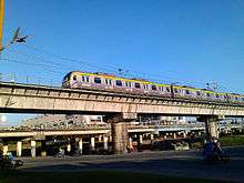
- Manila LRT Line 2
- Manila Observatory
- Plaza Delos Kapitanes
- San Jose Manggagawa Parish
- San Jose Seminary
- The Last Supper Monument (at Loyola Memorial Park)
- Urban Bliss Gymnasium
- Marikina River Park
- Riverbanks Center
- Batibot Garden
- e-Com Building
- Food Station
- ICT Building
- Marikina's Largest Pair of Shoes in the World
- Marimar Tree
- Old Steam Locomotive Train Park
- Philippine Science Centrum
- Renaissance Basketball Park
- Renaissance Café
- Renaissance Convention Center
- Renaissance Hotel
- River Grille
- Riverbanks Activity Center
- Riverbanks Amphitheater
- Riverbanks Convention Hall
- Riverbanks Ferry Terminal
- Riverbanks Gazebo
- Riverbanks Mall
- Riverbanks Police Station
- Riverbend Hotel and Convention Center
- Station Grill (Dampa sa Riverbanks)
- Sykes Riverbanks
- The Deck Café
Schools
- Barangka Elementary School
- Barangka National High School
- Kalayaan College
- Ateneo de Manila Grade School
- Loyola House of Studies (Ateneo de Manila)
- Loyola School of Theology
- Nativity Integrated
Roads
Major roads
- Marcos Highway
- A. Bonifacio Avenue
- Riverbanks Avenue
- Fidel V. Ramos Road (C5)
Streets
- General Julian Cruz (Chorillo) St
- Don Gonzalo Puyat St.
- St. Joseph St.
- Kabo Pio St.
- F. Tuazon St.
- M. Gonzales St.
- M. Cruz St.
- Himlayang Bayan St.
Bridges
- Marcos Bridge
- Macapagal Bridge
-

Barangay Hall
-

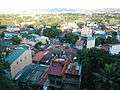
View from Loyola House of Studies (Ateneo de Manila University) and Loyola School of Theology
-
The Barangay houses down under the Loyola School of Theology, 3rd floor view deck
-

Barangay Baranka
-
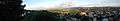
Panorama view of nearby houses and the far City of Marikina
See also
References
Prints
- Marikina Yellow Pages Directory, Directory Publications, Inc.
- Marikina Citizens' Factbook, Annual City Factbook
- Marikina River Digest, Official Publication of Marikina, in English
- Marikina Ngayon, Official Publication of Marikina, in Tagalog
External links
- fficial Website of the City Government of Marikina
- Marikina Media Library Center
- Marikina Interactive Map Viewer
- Marikina City Community Forum
- Marikina City Business Directory
- Marikina City Community Portal
- A Blog on Marikina City
Cities and municipalities | |||||||||||||||||||
| |||||||||||||||||||
| |||||||||||||||||||
See also: Administrative divisions of Metro Manila | |||||||||||||||||||