Baranagar
| Baranagar বরানগর | |
|---|---|
| Kolkata (West Bengal) | |
|
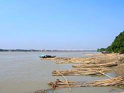
River Hoogly at Baranagar,Vivekananda Bridge far away. | |
 Baranagar Location in Kolkata | |
| Coordinates: 22°38′N 88°22′E / 22.64°N 88.37°ECoordinates: 22°38′N 88°22′E / 22.64°N 88.37°E | |
| Country |
|
| State | West Bengal |
| City | Kolkata |
| Government | |
| • Municipality Chairman | Aparna Moulik[1][2] |
| Elevation | 12 m (39 ft) |
| Population (2011) | |
| • Total | 248,466 |
| Languages | |
| • Official | Hindi , Bengali and English |
| Time zone | IST (UTC+5:30) |
| Area code(s) | 33 |
| Lok Sabha constituency | Dum Dum |
| Vidhan Sabha constituency | Baranagar |
Baranagar (Bengali: Baranagar) is a place in Kolkata. It is a municipality in Kolkata in the state of West Bengal, India. A railway station of the same name is on the Dankuni line off the Sealdah north section.
It is home to the Indian Statistical Institute, a prestigious institution devoted to the research, teaching and application of statistics, natural sciences and social sciences.
Baranagar is a major industrial center for the manufacture of agricultural and industrial machinery, chemicals, castor oil, and matches; there are also numerous cotton-processing companies.
History
The Dutch had homes here in the seventeenth century. Streynsham Master who visited the area in 1676 spoke of the hog factory where about 3,000 hogs a year were slaughtered and salted for export. Later it became the centre for the extensive jute trade, manufacturing gunny bags.[3] A major road parallel to the river Hooghly connects Baranagar Bazaar with Dakshineswar. In between temples such as Kaancher Mandir (i.e. Glass Temple), Joy Mitra Kali Bari, and Pathbari are located. In Kutighat (Baranagar), still there is an old house/lodge of Dutch merchants.
Geography
Baranagar is located at 22°38′N 88°22′E / 22.64°N 88.37°E.[4] It has an average elevation of 12 metres (39 feet).It is situated east of the Hooghly River. Baranagar Municipal Area lies between Sinthee More and Dunlop.
More particularly to say, the boundary of Baranagar is - in East, the Rail line from Sealdah towards Krishnanagar; in West - the holy river Ganga, in North - PWD road and in South - Baranagar Bazaar.It is connected by the holy Ganges to Dakshineshwar temple which lies just a quarter of a mile from this place.
Demographics
As of 2001 India census,[5] Baranagar had a population of 250,615. Males constitute 53% of the population and females 47%. Baranagar has an average literacy rate of 82%, higher than the national average of 59.5%; with 55% of the males and 45% of females literate. 8% of the population is under 6 years of age.
Education
Baranagarhouses the headquarters of the Indian Statistical Institute. Among the other less known colleges of Baranagar are Brahmananda Keshab Chandra College, Prasanta Chandra Mahalanobis Mahavidyalaya. Baranagar is also home to some schools like Baranagar Vidyamandir (Primary, Secondary and H.S., for boys and girls), Baranagar Ramakrishna Mission Ashrama Primary and High School,[6] Baranagar Narendra Nath Vidyamandir (started by Captain Narendra Nath Dutta), Rajkumari Memorial Girls' School, Khalsa Model Senior Secondary School,Dunlop Bridge (Started by Sikh Sangat Gurdwara, Dunlop Bridge), Ananda Ashram Sarada Vidyapith, Baranagar Netaji Colony Bharti Girls' Institution, Netaji High School, Baranagar Rameswar H.S. School,Ashokegarh Adarsha Vidyalaya, Jyotinagar Bidyashree Niketan, Sinthi Ram Krishna Sangha Vidya Mandir, Sinthee Ray Bahadur Badridas Tulsan Vidyapith, Mata Monmohini Secondary School, Baranagar Mayapith Girls' High School, Delhi Public School [North Kolkata] etc., and a Higher Secondary Urdu-medium school, Alambazar Urdu High school providing quality education to the local people.
Culture
Baranagar has a Kali temple at Dakshineswar, the Rashmoni Mandir named after its founder Rani Rashmoni. The Dakshineswar Kali Temple is a heritage building. Ramakrishna Paramahamsa was the priest and Swami Vivekananda visited this place in his youth. Baranagar Math near Pramanick ghat is the place where Swami Vivekananda and a few other disciples of Sri Ramakrishna Dev started their spiritual journey that culminated in forming the monastic order later located at Belur Math, the present headquarters of Ramakrishna Mission.[7] Cossipore Udyan Baati,[8] also called Cossipore Math, is another significant destination for the followers of Sri Ramakrishna, where he became the Kalpataru on 1 January 1886. Other places worth visiting are Jay Mitra Kalibari, Pramanick Kalibari, and Kouleswar Mandir. Pathbari Mandir is a place where Chaitanya Mahaprabhu, the great religious leader, set his foot on his way to Puri nearly four hundred years ago.here, in Baranagar a math has been set up very recently, called "Alambazar Math" in the heritage building where Swami Vivekananda first put up after coming back from abroad.[9] Tha Annapurna Temple and the newly built Omkarnath Temple are also other two attractions of the Mahamilan Math.
Baranagar has a gurdwara near Dunlop Bridge, a church near Sinthee More along with many mosques .
Majority of the population of Baranagar practises Hinduism.
References
- ↑ Official District Administration site Archived January 15, 2007, at the Wayback Machine.
- ↑ "Welcome to www.baranagarmunicipality.org". Retrieved 17 May 2015.
- ↑ Cotton, H.E.A., Calcutta Old and New, 1909/1980, pp 806-807, General Printers and Publishers Pvt. Ltd.
- ↑ "Maps, Weather, and Airports for Baranagar, India". Retrieved 17 May 2015.
- ↑ "Census of India 2001: Data from the 2001 Census, including cities, villages and towns (Provisional)". Census Commission of India. Archived from the original on 2004-06-16. Retrieved 2008-11-01.
- ↑ "Ramakrishna Mission Ashrama, Baranagar Mission". Retrieved 17 May 2015.
- ↑ "RKM -- Index". Retrieved 17 May 2015.
- ↑ Super User. "Home". Retrieved 17 May 2015.
- ↑ "AlambazarMath". Archived from the original on 2014-01-10. Retrieved 2013-09-09.
https://baranagar.wordpress.com/category/history-news-information-of-baranagar/
External links
![]() Kolkata/Northern fringes travel guide from Wikivoyage
Kolkata/Northern fringes travel guide from Wikivoyage