Banovina (region)
| Banovina | |
|---|---|
| Geographic region of Croatiaa | |
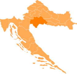 Banovina on a map of Croatia. Banovina is located in the southern part of Sisak-Moslavina County | |
| Country |
|
| Areab | |
| • Total | 4,463 km2 (1,723 sq mi) |
| Population (2001)c | |
| • Total | 183,730 |
| • Density | 41/km2 (110/sq mi) |
|
a Banovina is not designated as an official region, it is a geographic region only. b The figure is an approximation based on the territorial span of Sisak-Moslavina County. c The figure is an approximation based on the population of Sisak-Moslavina County. | |
Banovina (formerly known as Banska krajina, Banija) [1] is a geographical region in central Croatia, between the Sava, Una, and Kupa rivers. The main towns in the region include Petrinja, Glina, Kostajnica, and Dvor.
The area is almost entirely located in the Sisak-Moslavina County. During World War II, Banovina Banija was the site of one of the Ustaše's genocidal massacres against the Serbs. A half-century later, the area suffered during the Croatian War of Independence in the 1990s, with much of the population fleeing during the hostilities, many later returning.
See also
References
- ↑ Dalibor Brozović, Hrvatska enciklopedija (LZMK), 1. sv. (A – Bd), Leksikografski zavod »Miroslav Krleža«, Zagreb, 1999, str. 600; ISBN 953-6036-29-0
External links
- Mrvice s banskoga stola (Essay about names derived from the title Ban, in Croatian)
| Principal historical regions |  | ||||||||||||||
|---|---|---|---|---|---|---|---|---|---|---|---|---|---|---|---|
| Smaller regions |
| ||||||||||||||
| |||||||||||||||
Coordinates: 45°20′36″N 16°13′07″E / 45.34333°N 16.21861°E