Bankstown
| Bankstown Sydney, New South Wales | |||||||||||||
|---|---|---|---|---|---|---|---|---|---|---|---|---|---|
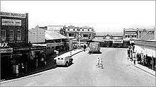
 Bankstown CBD | |||||||||||||
| Coordinates | 33°55′05″S 151°02′06″E / 33.91817°S 151.03497°ECoordinates: 33°55′05″S 151°02′06″E / 33.91817°S 151.03497°E | ||||||||||||
| Population | 30,572 (2011 census)[1] | ||||||||||||
| Established | 1795 | ||||||||||||
| Postcode(s) | 2200 | ||||||||||||
| Location | 20 km (12 mi) west of Sydney CBD | ||||||||||||
| LGA(s) | Canterbury-Bankstown Council | ||||||||||||
| State electorate(s) | |||||||||||||
| Federal Division(s) | |||||||||||||
| |||||||||||||
Bankstown is a suburb of south-western Sydney, in the state of New South Wales, Australia. It is 20 kilometres west of the Sydney central business district and is located in the local government area of Canterbury-Bankstown Council, having previously been the administrive centre of the City of Bankstown prior to 2016.
History
Prior to European settlement, Cumberland Plains Woodland occupied much of the area. Turpentine ironbark forest covered much of what is now Bankstown. The land was occupied by the Bediagal people. Their land bordered the Dharawal and the Darung people. The Aboriginal inhabitants strongly opposed the European settlers. The resistance ceased after a number of their leaders were killed or imprisoned in 1816. In that year an epidemic broke out amongst the native people which reduced the Aboriginal populations, this also contributed to the end of their resistance.bankstown is also culturally diverse [2]
In 1795, Matthew Flinders and George Bass explored up the Georges River for about 20 miles beyond what had been previously surveyed, and reported favourably to Governor Hunter of the land on its banks.[3] Hunter examined the country himself, and established one of the pioneer colonies there, called Bank's Town, today written as one word Bankstown.[4]
Hunter named the area Bankstown after Sir Joseph Banks, who travelled to Australia with Captain James Cook in 1770. The area of first European settlement along the river has been partially preserved as part of the Mirambeena Regional Park. The Bankstown City area includes large areas of the Georges River National Park.
One hundred years after its naming, Bankstown was proclaimed a municipal district on 9 September 1895. At this time there was a feeling of impending growth which was further strengthened by the promise of increased railway extensions. Municipalities that were already constituted became ambitious, and, in 1894, both Enfield and Auburn Councils announced their intention to absorb Bankstown as part of their own municipalities. However, a petition was organised and signed by 300 residents resulting in Bankstown retaining its individual status. And on 9 September 1895 it was proclaimed a municipal district. The first election was held on 2 November 1895. With 884 electors on the roll, 112 people voted to cast a total of 213 votes. Each ratepayer was entitled to 1.4 votes according to the assessed value of his property. Women were not allowed to vote at this stage.
The first town hall and Council Chambers were built in 1898 on the northern side of the Hume Highway (Liverpool Road), near Rookwood Road (site of the Three Swallows Hotel). The council chambers were relocated to a new building in South Terrace (now Old Town Centre Plaza) in June 1918. The building still stands and now has a shopping arcade running through it.
Bankstown Council relocated to its third premises in 1963 when the Civic Centre that is located on the corner of Chapel Road and The Mall was constructed. It included the Council Chambers or 'Roundhouse', as it's called and is still in use today as an administration building. The current town hall was built in 1973. The administration building was destroyed by fire on 1 July 1997. Council offices relocated to Bankstown Civic Tower (the blue tower) in 1999 and on 13 June 2000 Bankstown's now popular Central Park, where the former administration building once stood, was officially declared Paul Keating Park.[5]
On 27 May 1980, during a visit by Her Majesty Queen Elizabeth II, Bankstown was accorded city status.
Economy
Bankstown is the seat of major industry including the aviation, engineering and maintenance at Bankstown Airport. Other employers include small industrial operations, the public service and the retail industry. The suburb is affected with unusually high unemployment and is subject to a dedicated income management program specifically targeting the problem.[6]
Educational facilities
In 1862 the Church of England School was first opened and was commissioned as a public school in 1867. Bankstown's first public school was built where McLeod Reserve is currently situated in 1880. In 1882 49 boys and 36 girls were enrolled, and upkeep expenses totalled 219 pounds, eight shillings and 11 pence. The school's first headmaster was Dugald McLeod who taught at the school since its opening until 1912. The site of the well used by Bankstown Public School is today commemorated by a plaque.[7] The school was demolished in 1924 due to the development of North Bankstown School in the same year.[8] The current Bankstown Public School, located in Restwell Street Central Bankstown, opened in 1915. It recently celebrated its centenary (1915-2015). Since then Bankstown has seen the development of several different educational facilities, such as, Al Amanah College, Bankstown Senior College (formerly Bankstown Boys High School 1963-1991), Bankstown Girls High School, Georges River Grammar School, LaSalle Catholic College and St Euphemia College. Tertiary institutions located in the suburb include TAFE Bankstown and University of Western Sydney, Bankstown Campus.
World War II
In 1939 local residents were made privy to the events of World War II. Conscripted residents were required to report for duty at a drill hall on Canterbury Road, Belmore. Camps were set up in and around Canterbury Racecourse and local parks in the district. Residents with foreign names were sent to internment camps as there was growing suspicion about residents with foreign names. A portion of these folk were Australian citizens who served with the Australian armed forces during World War I.[9]
From March 1942 thousands of American servicemen arrived in Sydney. A large portion of these troops were stationed in Bankstown earning the suburb the nickname 'Yankstown'.
During World War II Bankstown Airport was established as a key strategic air base to support the war effort. After the arrival of Douglas MacArthur in Australia, control of Bankstown Airport was handed to US Forces, becoming home to US 35th Fighter Squadron and the 41st Pursuit Squadron of the United States Air Force and the United States Army Air Forces who occupied the airport from 1942 to 1944. In 1945 operations became the responsibility of the British Fleet Air Arm, known as HMS Nabberley,[10] until 1946, when it was handed back to the RAAF.
Bankstown Airport was home to several fighter units. Several "dummy houses" also existed in and around Bankstown Airport. These houses were built to make Bankstown Airport and its surrounds appear as a farm. There were gun pits in and around the airport to protect it from air raids and an anti-aircraft battery on the Corner of Bexley Road and Homer Street, Kingsgrove to help protect the approaches to the airport. Searchlight units of 62 Anti Aircraft Search Light Station personnel were based in Stacey Street as well as Australian Military Forces who rented houses in the street to provide accommodation for troops.
During this period an RAAF unit known as No. 1 Fighter Sector RAAF took control of the Capital Hall in Bankstown. This unit was formed in Bankstown, on 25 February 1942. Their living quarters were located next door and down the road from the hall & the staff were housed in galvanised iron barracks. Operations were handed over to the United States Army Air Corps on 10 April 1942 before they were transferred to a disused railway tunnel at St James railway station in Sydney. The unit was renamed, Air Defence Headquarters Sydney (ADHQ) on 21 January 1945 and moved into a three-storey semi-underground purpose built operations and plotting facility at Bankstown, known as the Bankstown Bunker.[13]
The area around Chapel Road Bankstown, were Paul Keating Park and the council chambers are now located, was the living quarters for the various military personnel who worked in Bankstown as well as training facilities for the various plotting rooms around Sydney. The site of today's court house was used to house British servicemen, whilst hundreds of army huts were constructed on the site of today's Bankstown Civic Centre.
World War II began Bankstowns industrial revolution. Few factories or industry of any consequence were located in Bankstown prior to 1945, this was changed dramatically between 1942 and 1954, especially when the Department of Aircraft Production gave approval for aircraft manufacturer Hawker De Havilland, to operate a factory at the airport for the production and manufacture of de Havilland Mosquito bombers. There are now over seven-thousand businesses operating within the Bankstown district.[2] Bankstown's population increased dramatically after World War II by people relocating from the inner-city areas and incoming migrants, mainly from Europe and towards the end of the 20th century from Asia and the rest of the world.
Bankstown Bunker
The Bankstown Bunker is a disused RAAF operations facility, located on the corner of Marion and Edgar Street, Bankstown. The specially constructed bunker became an important Royal Australian Air Force headquarters from 1945 until its closure in 1947.[14]
The Bankstown Bunker is of similar design to the underground Ops rooms of wartime England, which directed Britain's air defence fighter plane attacks on the invading German Luftwaffe. Entrance to the bunker was obtained through a concrete passageway which was well screened by a grassy slope, a stairway led to a virtual maze of corridors and hallways leading to various sections.[15] [16]
The Bankstown bunker is currently buried under a public park which lies at the end of Taylor Street.[17][18]
Commercial area
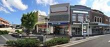
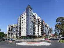
Bankstown's central business district is clustered around Bankstown railway station. The commercial area beside the railway station is known as Bankstown Plaza, while the ethnic diversity of the area has created a host of restaurants, eateries and cafes.
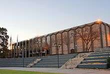
Bankstown Central Shopping Centre, formerly known as Centro Bankstown and previously known as Bankstown Square, is a large shopping centre, immediately to the northeast of the railway Station. It was first opened in 1966 and has been expanded a number of times. The latest redevelopment was completed on 22 June 2006 and includes a new Big W and Woolworths supermarket, a "Fresh Life food district", as well as various speciality shops and 1000+ new parking spaces.[19]
The Bankstown Central Library[20] has been serving Bankstown on its present site in The Mall since 1954. Eight years earlier in 1946, Bankstown became the first municipality to adopt the Library Act of 1939 by opening a Children's Library, located at Restwell Street. The Bankstown Central Library was demolished in 1981 to make way for a current facility which opened in 1983.
Transport
Bankstown railway station is on the Bankstown line of the Sydney Trains network. The rail line was built to Belmore in 1895 and then extended to Bankstown in 1909. The line was electrified in 1926. In 1928, the line was extended westwards from Bankstown to join the Main Suburban railway at Lidcombe and the Main South line to Liverpool. Bankstown is a major bus interchange for a number of bus services.
The Sydney Metropolitan Airport, more commonly known as Bankstown Airport, was established in 1940 and is constructed on 313 hectares. It has three runways, an extensive taxiway and includes a large business park containing over 170 businesses.
Parks and recreation
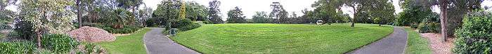
Major parks within Bankstown include McLeod Reserve, Bankstown Oval, Paul Keating Park and Bankstown City Gardens.
'Bankstown City Gardens' were opened to the public in 1973. These gardens consist of many unusual types of flora found in Bankstown and the surrounding area. The park consist of different areas, native, tropical, rose garden and Perennial.[21]
'Paul Keating Park' was built on the site of Bankstown Council's former administration building, after it was destroyed by fire on 1 July 1997.
Geology
Bankstown is situated in the Cumberland Plains region and is dominated by Bringelly Shale in the north and Ashfield shale in the south. The area south of Bankstown by Georges River is dominated by Hawkesbury sandstone where the soil tends to be shallow, sandy and infertile.
Population
Demographics
Bankstown has one of the most ethnically diverse communities in Australia. Bankstown is considered as one of the most multicultural areas in the country with over 60 different languages spoken by the people of this suburb.
In the 2011 Census the population of Bankstown is 30,572: of 50.5% female and 49.5% male.
The median/average age of the Bankstown population is 31 years of age, 6 years below the Australian average.
38.2% of people living in Bankstown were born in Australia. The other top responses for country of birth were Vietnam 12.7%, Lebanon 7.3%, China 5.5%, Macedonia 1.7%, Pakistan 1.5%.
16.9% of people speak English as their first language 23.5% Arabic, 17.3% Vietnamese, 4.7% Mandarin, 3.6% Cantonese, 3.3% Greek.
The religious make up of Bankstown is 26.2% Islam, 21.5% Catholic, 12.2% Buddhism, 8.7% No Religion, 8.6% Eastern Orthodox.
Notable residents
The following people are residents or former residents of Bankstown:
- Blake Ferguson, current Sydney Roosters player
- Paul Keating, former Prime Minister of Australia
- Brett Holman, former Socceroo and player of Aston Villa F.C., also played for Dutch Eredivisie club NEC Nijmegen and AZ Alkmaar
- Casey Donovan, winner of the second Australian Idol
- Paulini Curuenavuli, finalist from the first Australian Idol
- Melanie Roche, Olympic Medalist
- Brett Emerton, former Socceroo
- John and Ilsa Konrads, siblings and world record-breaking swimmers
Climate
Bankstown has a humid subtropical climate (Köppen climate classification: Cfa). Similarly to most of Western Sydney, it features warm to hot summers and mild winters. The average summer temperature range is from 17.6 °C (63.7 °F) to 27.8 °C (82.0 °F), although hot north-westerly winds can cause temperatures to rise up to +40 °C (104 °F). On average, Bankstown sees 8.8 days per year where the temperature rises above 35 °C (95 °F),[22] as opposed to only 3.0 days for Sydney Observatory Hill.,[23] The average winter temperature range is from 5.9 °C (42.6 °F) to 18.0 °C (64.4 °F). On average, 1 night per year sees a minimum temperature drop below freezing (0 °C).
The highest temperature recorded at Bankstown was 46.1 °C (115.0 °F) on 18 January 2013, and the lowest temperature recorded was -4.0 °C (24.8 °F) on 26 July 1968. Bankstown's annual mean rainfall is 869.0mm, slightly less than the Sydney CBD, which is affected more by coastal showers which do not penetrate very far inland.
| Climate data for Bankstown Airport | |||||||||||||
|---|---|---|---|---|---|---|---|---|---|---|---|---|---|
| Month | Jan | Feb | Mar | Apr | May | Jun | Jul | Aug | Sep | Oct | Nov | Dec | Year |
| Record high °C (°F) | 46.1 (115) |
43.3 (109.9) |
41.6 (106.9) |
36.9 (98.4) |
28.5 (83.3) |
25.4 (77.7) |
26.7 (80.1) |
30.2 (86.4) |
35.6 (96.1) |
39.7 (103.5) |
43.1 (109.6) |
43.6 (110.5) |
46.1 (115) |
| Average high °C (°F) | 28.2 (82.8) |
27.8 (82) |
26.2 (79.2) |
23.7 (74.7) |
20.5 (68.9) |
17.7 (63.9) |
17.2 (63) |
19.0 (66.2) |
21.7 (71.1) |
23.8 (74.8) |
25.3 (77.5) |
27.3 (81.1) |
23.2 (73.8) |
| Average low °C (°F) | 18.1 (64.6) |
18.1 (64.6) |
16.2 (61.2) |
12.7 (54.9) |
9.5 (49.1) |
6.7 (44.1) |
5.1 (41.2) |
6.0 (42.8) |
8.7 (47.7) |
11.8 (53.2) |
14.4 (57.9) |
16.6 (61.9) |
12.0 (53.6) |
| Record low °C (°F) | 10.4 (50.7) |
10.0 (50) |
7.8 (46) |
2.4 (36.3) |
1.3 (34.3) |
−1.9 (28.6) |
−4.0 (24.8) |
−0.7 (30.7) |
0.0 (32) |
4.4 (39.9) |
6.8 (44.2) |
6.3 (43.3) |
−4.0 (24.8) |
| Average precipitation mm (inches) | 90.8 (3.575) |
107.0 (4.213) |
100.3 (3.949) |
83.8 (3.299) |
67.9 (2.673) |
75.3 (2.965) |
44.1 (1.736) |
49.9 (1.965) |
43.8 (1.724) |
60.2 (2.37) |
78.6 (3.094) |
68.8 (2.709) |
869.0 (34.213) |
| Average precipitation days (≥ 0.2 mm) | 11.0 | 11.0 | 11.3 | 9.0 | 9.6 | 9.5 | 8.0 | 7.2 | 7.5 | 9.1 | 11.0 | 9.9 | 114.1 |
| Average relative humidity (%) | 54 | 57 | 55 | 54 | 55 | 55 | 50 | 44 | 45 | 48 | 52 | 51 | 52 |
| Source: [24] | |||||||||||||
References
- Sue Rosen 1996, Bankstown, a Sense of Identity
- ↑ Australian Bureau of Statistics (31 October 2012). "Bankstown (State Suburb)". 2011 Census QuickStats. Retrieved 7 July 2012.
- 1 2 About Bankstown Council Archived 5 December 2007 at the Wayback Machine.
- ↑ A Voyage to Terra Australis by Matthew Flinders at Project Gutenberg
- ↑ The Life of Captain Matthew Flinders, by Ernest Scott at Project Gutenberg
- ↑ Maltby, Kathy; Rosen, Sue – Bankstown: Sense of Identity. From Settlement to City. Civic Tower 66–72 Rickard Road Bankstown: Bankstown City Council. p. 13.
- ↑ Archived 27 March 2012 at the Wayback Machine.
- ↑ File:Mcleodreservewell.JPG – Wikipedia, the free encyclopedia. En.wikipedia.org. Retrieved on 16 July 2013.
- ↑ File:First public school in bankstown sign.jpg – Wikipedia, the free encyclopedia. En.wikipedia.org. Retrieved on 16 July 2013.
- ↑ Maltby, Kathy; Rosen, Sue – Bankstown: Sense of Identity. From Settlement to City. Civic Tower 66–72 Rickard Road Bankstown: Bankstown City Council. pp. 14/16.
- ↑ Index of Fleet Air Arm Air Stations in the Commonwealth 1939–1945. Fleetairarmarchive.net. Retrieved on 16 July 2013.
- ↑ You will have to do you own record search for this info (Type in Stacey Street for the key words. For the date type in 1940–1950 and press enter)
- ↑ A Pictorial History of Canterbury Bankstown. by Joan Lawrence, Brian Madden and Les Muir, Page 89,(Alexandria: Kingsclear Books 1999. Printed by Australian Print Group.) Retrieved on 13 August 2007.
- ↑ No. 1 Fighter Sector Headquarters RAAF, later known as No. 101 Fighter Control Unit RAAF
- ↑ Maltby, Kathy; Rosen, Sue – Bankstown: Sense of Identity. From Settlement to City. Civic Tower 66–72 Rickard Road Bankstown: Bankstown City Council. p. Pages 13.
- ↑ (information supplied by R. Eyers VAOC worker)
- ↑ Teenagers raid bunker. BunkerBoyz.org.
- ↑ Veitch, Alen (24 June 1971). "The Bankstown Bunker". Australian Post.
- ↑ Images of the Bankstown Bunker located in Condell Park. Archived 16 September 2006 at the Wayback Machine.
- ↑ Woodhead International
- ↑ Archived 22 March 2008 at the Wayback Machine.
- ↑ File:2007 0808klklk0001.JPG – Wikimedia Commons. Commons.wikimedia.org. Retrieved on 16 July 2013.
- ↑ "Climate statistics for Bankstown Airport". Bureau of Meteorology. Retrieved 21 Feb 2015.
- ↑ "Climate statistics for Sydney Observatory Hill". Bureau of Meteorology. Retrieved 21 Feb 2015.
- ↑ "Climate statistics for Bankstown Airport". Bureau of Meteorology. Retrieved 13 April 2013.
External links
| Wikimedia Commons has media related to Bankstown, New South Wales. |
- Bankstown City Council Website
- Community Profile
- 2001 Census Information
- State Electoral Districts of NSW
]