Bangor, New South Wales
| Bangor Sydney, New South Wales | |||||||||||||
|---|---|---|---|---|---|---|---|---|---|---|---|---|---|
 Bangor Shopping Centre | |||||||||||||
| Population | 5,620 (2011 census)[1] | ||||||||||||
| • Density | 1,371/km2 (3,550/sq mi) | ||||||||||||
| Established | 1836 | ||||||||||||
| Postcode(s) | 2234 | ||||||||||||
| Area | 4.1 km2 (1.6 sq mi) | ||||||||||||
| Location | 28 km (17 mi) south of Sydney CBD | ||||||||||||
| LGA(s) | Sutherland Shire | ||||||||||||
| State electorate(s) | |||||||||||||
| Federal Division(s) | Hughes | ||||||||||||
| |||||||||||||

Bangor is a suburb in southern Sydney, in the state of New South Wales, Australia. Bangor is located 28 kilometres south of the Sydney central business district, in the local government area of the Sutherland Shire in the area commonly called Menai. Bangor sits south of the Georges River and to the west of the Woronora River.
History
The name 'Bangor' was selected in 1895 by the land's owner, a farmer named Owen Jones, after his birthplace Bangor in Wales. To avoid confusion with Bangor in Tasmania, the Postmaster General's Office changed the suburb name to Menai in 1910. Another Australian Bangor is located in South Australia. Menai Bridge is a town opposite the original Bangor, on the Menai Strait in Wales. When Menai expanded, the eastern section was renamed Bangor in 1976.[2]
As part of the modern development of Bangor, the streets were all named with an Aboriginal theme.
Commercial area
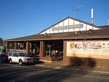
Bangor is a mostly residential suburb with a small shopping centre which consists of Bangor Community Pharmacy, Bangor Post Office, Bangor Bakery, The Chicken Spot, IGA, Peter's Bangor Chinese, Thai Max, ABC School Wear, Bangor Dry Cleaners, Bangor Butchers and Doug Frost Swim School.
Schools
- Bangor Public School [K-6].
- Holy Family Catholic College [K-6]
- Aquinas Catholic College [7-12]
Churches
- Holy Catholic Family Parish Church
- Salvation Army
Transport
The main road running through Bangor and Menai is Menai Road. The Bangor Bypass was completed in February 2005 to alleviate traffic in the area.
Transdev NSW buses (routes 961 and 962) connect Bangor to Menai, Illawong, Alfords Point, Barden Ridge, Padstow, Bankstown, Sutherland, Kirrawee, Gymea and Miranda. Metrobus M92 runs between Sutherland and Parramatta via Bankstown. It also runs a weekend bus service to Cronulla.
The closest train station is Sutherland, on the Illawarra line; although Padstow on the East Hills/Airport line is also frequently used. Veolia buses service Bangor from both these train stations.
A family friendly cycle way runs from Sutherland to Padstow through Bangor, which links up with the broader Sydney cycle way.
Sport and recreation
Bangor has tennis courts and two sporting ovals (Akuna Oval and Billa Oval) named after the roads they are situated on. Bangor is home to the Bangor Brumbies soccer club and its home field is Billa Oval. The Bangor Scout Group [3] was established in 1986 with a Scout Hall in Ross Reserve in Pyree Street and caters for youth aged from 6 to 26 years old.
The nearby rivers and extensive bush areas are popular with the locals and offer a variety of outdoor activities including bush walking, mountain bike riding, canoeing, kayaking, rowing, fishing.
References
- ↑ Australian Bureau of Statistics (31 October 2012). "Bangor (State Suburb)". 2011 Census QuickStats. Retrieved 2012-07-07.
- ↑ The Book of Sydney Suburbs, Compiled by Frances Pollon, Angus & Robertson Publishers, 1990, Published in Australia ISBN 0-207-14495-8
- ↑ http://www.bangorscouts.org.au/
Coordinates: 34°01′09″S 151°01′38″E / 34.01908°S 151.02735°E