Bale, Croatia
| Bale/Valle | ||
|---|---|---|
| Municipality | ||
| Bale/Valle Municipality Općina Bale - Comune di Valle[1] | ||
|
View of Bale | ||
| ||
 Bale/Valle Location of Bale/Valle in Croatia | ||
| Coordinates: 45°02′N 13°46′E / 45.033°N 13.767°ECoordinates: 45°02′N 13°46′E / 45.033°N 13.767°E | ||
| Country |
| |
| County | Istria | |
| Government | ||
| • Municipal mayor | Edi Pastrovicchio | |
| Area | ||
| • Total | 81.65 km2 (31.53 sq mi) | |
| Elevation | 142 m (466 ft) | |
| Population (2011)[2] | ||
| • Total | 1,127 | |
| • Density | 14/km2 (36/sq mi) | |
| Time zone | CET (UTC+1) | |
| • Summer (DST) | CEST (UTC+2) | |
| Postal code | 52111 | |
| Area code(s) | 52 | |
| Website |
www | |
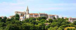

Bale/Valle (Italian: Valle d'Istria, Istro-Romanian: Vale) is a small town and municipality in Istria County, Croatia.
The origins of the settlement lie in the Roman stronghold of Castrum Vallis, built by Caius Palcrus to protect the salt-pan road from Pula/Pola to Poreč/Parenzo.[3]
The municipality covers a total area of 81.65 km2 (31.53 sq mi)[4] and has a total population of 1,127. The town is officially bilingual, Italian and Croatian, hence both town names are official and equal. Bale/Valle is connected to the Croatian highway network by an exit on the A9 motorway (E751), part of the Istrian Y.
Dinosaur fossils, most notably those of Histriasaurus, were found near the town and are kept at the town museum.
Monuments
- Holy Spirit Church built in the 15th century.
See also
References
- ↑ The Statute of Bale. See art. 3
- ↑ "Population by Age and Sex, by Settlements, 2011 Census: Bale". Census of Population, Households and Dwellings 2011. Zagreb: Croatian Bureau of Statistics. December 2012.
- ↑ "Bale Istra". histrica.com (in Croatian). Retrieved 16 November 2016.
- ↑ "Welcome to Bale". bale-valle.hr. Retrieved 17 August 2015.
| Wikimedia Commons has media related to Bale-Valle. |
Subdivisions of Istria County | ||
|---|---|---|
| Cities and towns |  | |
| Municipalities | ||