Baldwyn, Mississippi
| Baldwyn, Mississippi | |
|---|---|
| City | |
| City of Baldwyn | |
|
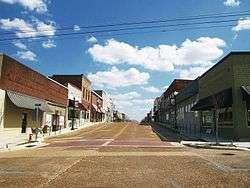
Downtown Baldwyn | |
| Motto: "Where Tradition Touches Tomorrow" | |
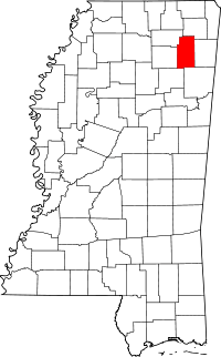
 Location in Lee County and Prentiss County and the state of Mississippi | |
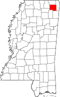
 Baldwyn Location within the contiguous United States of America | |
| Coordinates: 34°30′32″N 88°38′22″W / 34.50889°N 88.63944°WCoordinates: 34°30′32″N 88°38′22″W / 34.50889°N 88.63944°W | |
| Country |
|
| State |
|
| Counties | Lee, Prentiss |
| Incorporated | April 1, 1861 |
| Government | |
| • Type | Mayor–Council |
| • Mayor | Michael James (I) |
| • Council | |
| Area | |
| • Total | 11.6 sq mi (30.0 km2) |
| • Land | 11.5 sq mi (29.9 km2) |
| • Water | 0.1 sq mi (0.1 km2) |
| Elevation | 404 ft (123 m) |
| Population (2010)[1] | |
| • Total | 3,297 |
| • Density | 280/sq mi (110/km2) |
| Time zone | CST (UTC−06:00) |
| • Summer (DST) | CDT (UTC−05:00) |
| ZIP code(s) | 38824, 38849 |
| Area code(s) | 662 |
| FIPS code | 28-02700 |
| GNIS feature ID | 666483[2] |
| Major airport | MEM |
| Website |
www |
Baldwyn is a city located in Lee County and Prentiss County, Mississippi.[2] The population was 3,297 at the 2010 census.[1]
History
Located five miles north of Guntown, the main street of Baldwyn runs along the county line of Lee and Prentiss counties. The city has the unusual distinction of having been incorporated in four counties. It was incorporated by an Act of the Legislature in Tishomingo and Itawamba counties on April 1, 1861. Tishomingo County was divided into Alcorn, Prentiss and Tishomingo in 1870, while Lee was formed from parts of Itawamba and Pontotoc counties in 1866.[3]
Baldwyn is an outgrowth of the village of Carrollville: when the Mobile and Ohio Railroad was being built during the years of 1848 to 1861, it missed Carrollville by one and one-half miles and the citizens moved to the new town of Baldwyn, which was named for the civil engineer who surveyed the road through the town. Tishomingo, chief of the Chickasaw, lived at old Carrollville but died at Little Rock, Arkansas in 1839 of smallpox while being moved west with his tribe.[3]
Geography
In the 2000 census, 1,892 of the city's 3,321 residents (57.0%) lived in Prentiss County and 1,429 (43.0%) in Lee County. According to the United States Census Bureau, the city has a total area of 11.6 square miles (30.0 km²), of which 11.5 square miles (29.9 km²) is land and 0.1 square mile (0.1 km²) (0.43%) is water.[4]
Demographics
| Historical population | |||
|---|---|---|---|
| Census | Pop. | %± | |
| 1870 | 133 | — | |
| 1880 | 477 | 258.6% | |
| 1900 | 560 | — | |
| 1910 | 787 | 40.5% | |
| 1920 | 922 | 17.2% | |
| 1930 | 1,106 | 20.0% | |
| 1940 | 1,279 | 15.6% | |
| 1950 | 1,567 | 22.5% | |
| 1960 | 2,023 | 29.1% | |
| 1970 | 2,366 | 17.0% | |
| 1980 | 3,427 | 44.8% | |
| 1990 | 3,204 | −6.5% | |
| 2000 | 3,321 | 3.7% | |
| 2010 | 3,297 | −0.7% | |
| Est. 2015 | 3,339 | [5] | 1.3% |
As of the census[7] of 2000, there were 3,321 people, 1,331 households, and 886 families residing in the city. The population density was 287.9 sq mi). There were 1,472 housing units at an average density of 127.6 per square mile. The racial makeup of the city was 54.53% White, 43.87% African American, 0.24% Native American, 0.30% from other races, and 1.05% from two or more races. Hispanic or Latino of any race were 0.99% of the population.
There were 1,331 households out of which 33.1% had children under the age of 18 living with them, 42.2% were married couples living together, 20.2% had a female householder with no husband present, and 33.4% were non-families. 31.5% of all households were made up of individuals and 15.7% had someone living alone who was 65 years of age or older. The average household size was 2.42 and the average family size was 3.02.
In the city the population was spread out with 26.8% under the age of 18, 9.7% from 18 to 24, 24.1% from 25 to 44, 21.4% from 45 to 64, and 18.0% who were 65 years of age or older. The median age was 36 years. For every 100 females there were 79.9 males. For every 100 females age 18 and over, there were 73.5 males.
The median income for a household in the city was $26,016, and the median income for a family was $37,598. Males had a median income of $27,162 versus $21,174 for females. The per capita income for the city was $15,430. About 19.9% of families and 24.0% of the population were below the poverty line, including 32.9% of those under age 18 and 23.3% of those age 65 or over.
Education
Baldwyn is served by the Baldwyn School District.
Infrastructure
Transportation
The Booneville/Baldwyn Airport is owned by the cities of Booneville and Baldwyn. It is located in Prentiss County, six nautical miles (7 mi, 11 km) southwest of Booneville's central business district.[8]
Notable people
- James Davis (born 1948), former chief financial officer of Stanford Financial Group who plead guilty for his role in a US$7 billion Ponzi scheme
- Tim Ford (1951–2015), American politician
- Laura Pendergest-Holt (born 1973), former chief investment officer of Stanford Financial Group who pleaded guilty for her role in a US$7 billion Ponzi scheme
See also
- Brice's Cross-Roads National Battlefield
- List of cities in Mississippi
- National Register of Historic Places listings in Lee County, Mississippi
References
- 1 2 "2010 City Population and Housing Occupancy Status". U.S. Census Bureau. Archived from the original on July 21, 2011. Retrieved May 14, 2012.
- 1 2 U.S. Geological Survey Geographic Names Information System: Baldwyn
- 1 2 Brieger, James F., ed. (1980). Hometown Mississippi. Historical and Genealogical Association of Mississippi. p. 291.
- ↑ "Subcounty population estimates: Mississippi 2000-2006" (CSV). United States Census Bureau, Population Division. 2007-06-28. Retrieved 2007-07-21.
- ↑ "Annual Estimates of the Resident Population for Incorporated Places: April 1, 2010 to July 1, 2015". Retrieved July 2, 2016.
- ↑ "Census of Population and Housing". Census.gov. Archived from the original on May 11, 2015. Retrieved June 4, 2015.
- ↑ "American FactFinder". United States Census Bureau. Archived from the original on September 11, 2013. Retrieved 2008-01-31.
- ↑ FAA Airport Master Record for 8M1 (Form 5010 PDF). Federal Aviation Administration. Effective 30 June 2011.
External links
| |||||||||||||||||||||||||||||||||||||||||||||||||||||||