Balakliia
| Balakliia Балаклія | ||
|---|---|---|
|
Main Street of Balaklija | ||
| ||
 Map of Ukraine with Balakliia highlighted | ||
 Balakliia Location of Balakliia | ||
| Coordinates: 49°27′57″N 36°52′04″E / 49.46583°N 36.86778°ECoordinates: 49°27′57″N 36°52′04″E / 49.46583°N 36.86778°E | ||
| Country |
| |
| Oblast | Kharkiv Oblast | |
| Raion | Kharkivskyi Raion | |
| Founded | 1663 | |
| Area | ||
| • Total | 35 km2 (14 sq mi) | |
| Elevation | 79 m (259 ft) | |
| Population (2001) | ||
| • Total | 32,408 | |
| Time zone | EET (UTC+2) | |
| • Summer (DST) | EEST (UTC+3) | |
| Postal code | 64200 | |


Balakliia (Ukrainian: Балаклія, Russian: Бaлaклeя, translit. Balakleya) is a city in the Kharkiv Oblast (province) of eastern Ukraine. It is the administrative center of the Balakliyskyi Raion (district), and is an important railroad junction in the oblast.
-

Balakliia City Sign
-

Balakliia Ambulance in front of Local Hospital
-

City hall
-
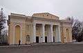
Palace of Culture
-

Balaklija Lyceum
-

Children's park
| Raions | |||||||
|---|---|---|---|---|---|---|---|
| Cities |
| ||||||
| |||||||
This article is issued from Wikipedia - version of the 7/27/2015. The text is available under the Creative Commons Attribution/Share Alike but additional terms may apply for the media files.